
Farmington, New Hampshire facts for kids
Quick facts for kids
Farmington, New Hampshire
|
||
|---|---|---|
|
Town
|
||

Farmington town hall
|
||
|
||

Location within Strafford County, New Hampshire
|
||
| Country | United States | |
| State | New Hampshire | |
| County | Strafford | |
| Settled | 1770s | |
| Incorporated | 1798 | |
| Villages |
|
|
| Area | ||
| • Total | 36.9 sq mi (95.7 km2) | |
| • Land | 36.6 sq mi (94.8 km2) | |
| • Water | 0.3 sq mi (0.9 km2) | |
| Elevation | 285 ft (87 m) | |
| Population
(2020)
|
||
| • Total | 6,722 | |
| • Density | 184/sq mi (70.9/km2) | |
| Time zone | UTC−5 (EST) | |
| • Summer (DST) | UTC−4 (EDT) | |
| ZIP code |
03835
|
|
| Area code(s) | 603 | |
| FIPS code | 33-26020 | |
| GNIS feature ID | 0873596 | |

Farmington is a town in Strafford County, New Hampshire, United States. In 2020, 6,722 people lived here. Farmington is known for its natural beauty. It is home to Blue Job State Forest, the Tebbetts Hill Reservation, and Baxter Lake.
The main part of town, called the Farmington census-designated place, had 3,824 residents in 2020. It is located where New Hampshire routes 75 and 153 meet.
Contents
History of Farmington
The Abenaki people, who are Native Americans, once lived in this area. They called it Chemung, which means "canoe place." They used the three local rivers—the Cocheco, the Ela, and the Mad—for travel. They had a camp on Meetinghouse Hill where they built birch bark canoes. The river valley was mostly wild, and native people from the north traveled through it to Lake Winnipesaukee for hunting.
Early European Settlement
As more Europeans settled in New Hampshire, the area that became Farmington was first part of Rochester. Rochester was officially started in 1722. Native people were losing their lands and sometimes raided settlements near Dover. To stop these raids, the government in Portsmouth decided to build a fort in 1721. A road was built from Dover to supply the fort. This road, called Bay Road, was finished in 1722. The town of Farmington would later grow along this road.
The last native attack in the area happened in 1748. By 1749, most Native Americans had left due to fighting or sickness. Farmers began to work the land. Gristmills used the power of streams to grind grain, and sawmills cut down the many trees. The first wooden house in the village was built in 1782. In 1790, Jonas March opened a store. This area became known as "March's Dock," then "Farmington Dock," and finally just "The Dock."
Becoming a Town
People living in the Northwest Parish of Rochester had to pay to support the church and minister in Rochester, which was about 12 miles away. This distance made it hard for them to attend services. In the 1770s, people started asking to become their own town. Their first request in 1783 was turned down. However, another request in 1798 was approved. With about 1,000 people, Farmington officially became a town. In 1800, a large two-story church was built on Meetinghouse Hill. That same year, John Wingate opened a blacksmith shop and later a tavern.
Growth and Industry
In the 1800s, Farmington became famous for making shoes. It was one of the first places to use machines instead of handwork to make shoes. Shoe manufacturing began in 1836. Martin Luther Hayes took over a shoe business and made it successful. In 1849, a railroad connected Farmington to Dover. The line was extended to Alton Bay in 1851. Shoes were sent to Boston to be sold.
After the Civil War, the shoe business grew even more. Many factories were built. Farmington was even called "The Shoe Capital of New Hampshire." Other factories made knives, underwear, wooden boxes, wooden handles, and carriages. A big fire in 1875 destroyed much of the town center, but the community rebuilt. The F. W. Browne Company made brushes. In 1915, Booker T. Washington ordered brooms from them for the Tuskegee Institute. At one time, Farmington had five blacksmith shops, a movie theater, and two hotels. However, a financial crisis in 1893, called the Panic of 1893, caused many shoe factories to close. Over time, most local industries faded. Many factories were torn down or used for other things.
-
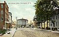
Central Street in 1908
-
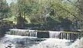
Cochecho River in 1912
-
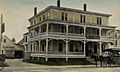
Central House in 1913
-
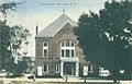
Opera House in 1914
-
Shoe factory in 1915


Geography
Farmington covers about 95.7 square kilometers (37.0 square miles). Most of this area, 94.8 square kilometers (36.6 square miles), is land. The rest, 0.9 square kilometers (0.3 square miles), is water. Water makes up about 0.95% of the town's total area.
The town has several rivers, including the Cocheco River, Ela River, Mad River, and Rattlesnake River. These rivers drain the town's land. Baxter Lake is the largest body of water in Farmington. It is located on the southeastern border.
Mountains and Watersheds
Part of the Blue Hills Range is in the southwest of Farmington. These hills are part of the White Mountains. The highest point in Farmington is Blue Job Mountain. It is 1,350 feet (411 meters) above sea level. This mountain is near the town's southwestern border.
Most of Farmington is in the Piscataqua River watershed. A watershed is an area of land where all the water drains into a single river or lake. A small part of the western corner of town is in the Merrimack River watershed.
Roads and Nearby Towns
New Hampshire Routes 11, 75, and 153 all pass through Farmington.
Farmington is next to several other towns:
- Middleton (north)
- Milton (northeast)
- Rochester (southeast)
- Strafford (southwest)
- Barnstead (west at one point)
- Alton (northwest at one point)
- New Durham (northwest)
Demographics
| Historical population | |||
|---|---|---|---|
| Census | Pop. | %± | |
| 1790 | 786 | — | |
| 1800 | 1,029 | 30.9% | |
| 1810 | 1,272 | 23.6% | |
| 1820 | 1,716 | 34.9% | |
| 1830 | 1,464 | −14.7% | |
| 1840 | 1,380 | −5.7% | |
| 1850 | 1,699 | 23.1% | |
| 1860 | 2,275 | 33.9% | |
| 1870 | 2,063 | −9.3% | |
| 1880 | 3,044 | 47.6% | |
| 1890 | 3,064 | 0.7% | |
| 1900 | 2,265 | −26.1% | |
| 1910 | 2,621 | 15.7% | |
| 1920 | 2,461 | −6.1% | |
| 1930 | 2,698 | 9.6% | |
| 1940 | 3,095 | 14.7% | |
| 1950 | 3,454 | 11.6% | |
| 1960 | 3,287 | −4.8% | |
| 1970 | 3,588 | 9.2% | |
| 1980 | 4,630 | 29.0% | |
| 1990 | 5,739 | 24.0% | |
| 2000 | 5,774 | 0.6% | |
| 2010 | 6,786 | 17.5% | |
| 2020 | 6,722 | −0.9% | |
| U.S. Decennial Census | |||

In 2010, Farmington had 6,786 people living in 2,592 households. Of these, 1,813 were families. The population density was about 180.8 people per square mile (70.9/km2). There were 2,832 housing units in the town.
Most of the people in Farmington were white (96.8%). A small percentage were African American (0.5%), American Indian or Alaska Native (0.3%), or Asian (0.5%). About 1.7% of the population identified as two or more races. About 0.8% of the people were Hispanic or Latino.
In 2010, about 29.7% of households had children under 18. About 51.0% were married couples living together. About 12.6% were led by a female householder without a husband. About 30.1% were not families. The average household had 2.62 people, and the average family had 3.01 people.
The population's age breakdown in 2010 was:
- 23.9% were under 18 years old.
- 8.5% were 18 to 24 years old.
- 26.4% were 25 to 44 years old.
- 30.2% were 45 to 64 years old.
- 11.1% were 65 years or older.
The average age in Farmington was 39.2 years. For every 100 females, there were about 98.7 males.
Between 2012 and 2016, the average yearly income for a household in Farmington was about $52,305. This was a bit lower than the average for the county and the state. The average income for a family was $68,693. About 7.2% of families and 11.5% of all people in Farmington lived below the poverty line. This included 17.5% of people under 18 and 3.2% of people 65 or older.

Notable people

Many interesting people have connections to Farmington:
- Shirley Barker (1911–1965), an author, poet, and librarian.
- Harry Bemis (1874–1947), a baseball catcher for the Cleveland Naps.
- Nehemiah Eastman (1782–1856), a lawyer, banker, and politician.
- Winfield Scott Edgerly (1846–1927), a U.S. Army brigadier general.
- Joseph W. Furber (1814–1884), a politician from Minnesota.
- Joseph Hammons (1787–1836), a U.S. congressman.
- Wingate Hayes (1823–1877), a U.S. Attorney and Speaker of the Rhode Island House of Representatives.
- Alonzo Nute (1826–1892), a U.S. congressman.
- Raymond Pearl (1879–1940), a biologist known for studying aging.
- Lawrence Lee Pelletier (1914–1995), the 16th president of Allegheny College.
- Mary Lemist Titcomb (1852–1932), a librarian.
- Clara Augusta Jones Trask (1839–1905), a writer of popular short novels.
- Henry Wilson (1812–1875), the 18th Vice-President of the United States (1873–1875).
See also
 In Spanish: Farmington (Nuevo Hampshire) para niños
