Barnstead, New Hampshire facts for kids
Quick facts for kids
Barnstead, New Hampshire
|
|
|---|---|
|
Town
|
|

Barnstead Parade
|
|

Location in Belknap County, New Hampshire
|
|
| Country | United States |
| State | New Hampshire |
| County | Belknap |
| Incorporated | 1767 |
| Villages |
|
| Area | |
| • Total | 44.9 sq mi (116.4 km2) |
| • Land | 43.1 sq mi (111.5 km2) |
| • Water | 1.9 sq mi (4.9 km2) 4.18% |
| Elevation | 505 ft (154 m) |
| Population
(2020)
|
|
| • Total | 4,915 |
| • Density | 114/sq mi (44.1/km2) |
| Time zone | UTC-5 (Eastern) |
| • Summer (DST) | UTC-4 (Eastern) |
| ZIP codes |
03218 (Barnstead)
03225 (Center Barnstead) |
| Area code(s) | 603 |
| FIPS code | 33-03220 |
| GNIS feature ID | 0873537 |
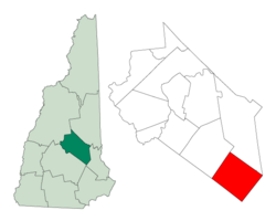
Barnstead is a town in Belknap County, New Hampshire, United States. It's a lovely place with a population of 4,915 people, according to the 2020 census. This was a small increase from 4,593 people in 2010.
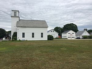
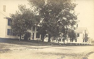
Barnstead is known for its beautiful Suncook Lakes. The town also includes a few smaller areas called villages. These are Center Barnstead, Barnstead Parade, and South Barnstead.
Contents
History of Barnstead
How Barnstead Got Its Start
The town of Barnstead was officially created on May 20, 1727. This happened when Lieutenant Governor John Wentworth gave permission for people to settle there. The first settlers arrived in 1765.
Just two years later, in 1767, Governor John Wentworth made Barnstead an official town. Many of the first families came from two places: Barnstable, Massachusetts, and Hempstead, New York. That's how Barnstead got its name – it's a mix of those two places!
Life in Early Barnstead
Barnstead isn't very mountainous, but it has rolling hills. These hills were perfect for raising animals like sheep. By 1830, there were about 2,500 sheep in the town! Farmers found the soil easy to work with and very productive.
The Suncook River and its smaller streams were very important. They provided water power for many different mills. By 1859, Barnstead had a factory that made woolen cloth. There were also seven sawmills, which cut wood. Other mills made shingles and clapboards for houses. There were even places called tanneries that made leather. Barnstead produced a lot of lumber and supplied it to nearby towns.
In 1874, a railroad came to Barnstead, making it easier to travel and transport goods.
Geography of Barnstead

Barnstead covers about 116.4 square kilometers (about 45 square miles). Most of this area is land, with about 4.9 square kilometers (1.9 square miles) being water. This means about 4.2% of the town is water.
The highest point in Barnstead is about 363 meters (1,190 feet) above sea level. This spot is near the town's northern border. The Suncook River flows through Barnstead. All the water in Barnstead eventually flows into the Merrimack River.
How to Get Around Barnstead
Several main roads help people travel through Barnstead:
- New Hampshire Route 28 goes from north to south. It connects Barnstead to towns like Alton and Wolfeboro in the north. To the south, it leads to Pittsfield and Suncook.
- New Hampshire Route 126 starts in Center Barnstead. It heads southeast towards Strafford and Barrington.
- New Hampshire Route 107 passes through the western part of Barnstead. It connects Pittsfield in the south to Laconia in the north.
Neighboring Towns
Barnstead shares its borders with these towns:
- Alton (to the north)
- Strafford (to the east)
- Pittsfield (to the south)
- Gilmanton (to the west)
Population Changes in Barnstead
Barnstead's population has changed a lot over the years. In 1790, there were 807 people. The population grew steadily for many years, reaching over 2,000 by 1830. Then, it slowly decreased for a long time. By 1920, it was down to 873 people.
However, since the 1960s, Barnstead has seen a lot of growth! The population has increased quite a bit, reaching 4,915 people in 2020.
| Historical population | |||
|---|---|---|---|
| Census | Pop. | %± | |
| 1790 | 807 | — | |
| 1800 | 1,161 | 43.9% | |
| 1810 | 1,477 | 27.2% | |
| 1820 | 1,805 | 22.2% | |
| 1830 | 2,047 | 13.4% | |
| 1840 | 1,945 | −5.0% | |
| 1850 | 1,848 | −5.0% | |
| 1860 | 1,885 | 2.0% | |
| 1870 | 1,543 | −18.1% | |
| 1880 | 1,296 | −16.0% | |
| 1890 | 1,264 | −2.5% | |
| 1900 | 1,072 | −15.2% | |
| 1910 | 1,081 | 0.8% | |
| 1920 | 873 | −19.2% | |
| 1930 | 791 | −9.4% | |
| 1940 | 804 | 1.6% | |
| 1950 | 846 | 5.2% | |
| 1960 | 850 | 0.5% | |
| 1970 | 1,119 | 31.6% | |
| 1980 | 2,292 | 104.8% | |
| 1990 | 3,100 | 35.3% | |
| 2000 | 3,886 | 25.4% | |
| 2010 | 4,593 | 18.2% | |
| 2020 | 4,915 | 7.0% | |
| U.S. Decennial Census | |||
Education in Barnstead
Barnstead has one elementary school called Barnstead Elementary School. This school teaches students from pre-kindergarten all the way up to 8th grade.
After 8th grade, students go to high school at Prospect Mountain High School. This is a regional high school located in the nearby town of Alton.
Famous People from Barnstead
Some interesting people have connections to Barnstead:
- Russell Banks (1940–2023) was a famous writer and poet. He lived in Barnstead when he was a child.
- Harriet Patience Dame (1815–1900) was born in Barnstead. She was a brave nurse during the Civil War.
- Fanny E. Minot (1847–1919) was also born in Barnstead. She became the national president of the Woman's Relief Corps.
- S. Millett Thompson (?–1911) was a second lieutenant in the Union Army during the Civil War.
- Harrison Thyng (1918–1983) was a brigadier general in the U.S. Air Force.
- Hiram A. Tuttle (1837–1911) was a merchant who became the 43rd Governor of New Hampshire.
See also
 In Spanish: Barnstead (Nuevo Hampshire) para niños
 | Stephanie Wilson |
 | Charles Bolden |
 | Ronald McNair |
 | Frederick D. Gregory |


