Mad River (Cocheco River tributary) facts for kids
Quick facts for kids Mad River |
|
|---|---|

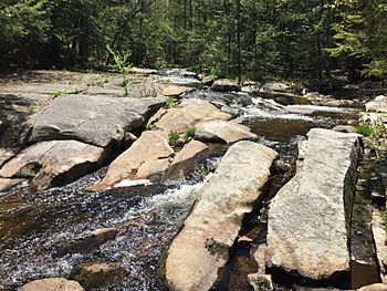
Ledges near River Road in Farmington, NH
|
|
| Country | United States |
| State | New Hampshire |
| County | Strafford |
| Town | Farmington |
| Physical characteristics | |
| Main source | Nubble Pond Farmington 715 ft (218 m) 43°21′4″N 71°6′1″W / 43.35111°N 71.10028°W |
| River mouth | Cocheco River Farmington village 270 ft (82 m) 43°23′11″N 71°4′2″W / 43.38639°N 71.06722°W |
| Length | 5.2 mi (8.4 km) |
The Mad River is a river in eastern New Hampshire, United States. It is about 5.2 miles (8.4 kilometers) long. This river is a tributary, which means it flows into a larger river. The Mad River joins the Cocheco River.
The Cocheco River is part of a bigger system called the Piscataqua River watershed. A watershed is an area of land where all the water drains into a common river, lake, or ocean. For the Mad River, all its water eventually flows into the Atlantic Ocean.
River's Journey
The Mad River is found entirely within the town of Farmington, New Hampshire. It begins in a place called Nubble Pond. This pond is located between two mountains, Nubble Mountain and Hussey Mountain.
From Nubble Pond, the river first flows towards the northwest. Then, it changes direction and flows towards the northeast. Its journey ends when it meets the Cocheco River. This meeting point is close to the center of Farmington town.
River's Drop
The Mad River flows downhill quite a bit during its short journey. Over its 5-mile (8-kilometer) path, the river drops more than 500 feet (150 meters). This means it goes from a higher elevation to a much lower one.
In some parts of the river, the water flows over beautiful rock formations called ledges. These ledges create scenic spots along the river's route.
 | James B. Knighten |
 | Azellia White |
 | Willa Brown |


