Ela River facts for kids
Quick facts for kids Ela River |
|
|---|---|

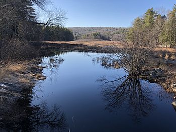
Wetland on the Ela River in New Durham, NH
|
|
| Country | United States |
| State | New Hampshire |
| County | Strafford |
| Towns | New Durham, Farmington |
| Physical characteristics | |
| Main source | Coldrain Pond New Durham 668 ft (204 m) 43°27′3″N 71°8′34″W / 43.45083°N 71.14278°W |
| River mouth | Cocheco River Farmington 278 ft (85 m) 43°23′20″N 71°4′12″W / 43.38889°N 71.07000°W |
| Length | 10.6 mi (17.1 km) |
The Ela River is a small river in eastern New Hampshire, United States. It is about 10.6 miles (17.1 kilometers) long. This river is a tributary of the Cocheco River. A tributary is a smaller stream or river that flows into a larger one. The Cocheco River is part of a bigger system called the Piscataqua River watershed. This watershed eventually carries water to the Atlantic Ocean.
Contents
Where the Ela River Starts
The Ela River begins in a place called Coldrain Pond. This pond is located in the town of New Durham, New Hampshire. Coldrain Pond is about 4 miles (6 km) east of a much larger lake, Lake Winnipesaukee. The starting point of a river is called its source. The Ela River's source is quite high up, at about 668 feet (204 meters) above sea level.
The River's Journey
From Coldrain Pond, the Ela River first flows south. On its way, it passes through another small body of water called Club Pond. After Club Pond, the river changes direction. It turns towards the southeast. As it flows, the river gradually goes downhill. This downhill path helps the water keep moving.
Path to the Cocheco
The Ela River continues its journey southeast until it reaches the town of Farmington, New Hampshire. In Farmington, the Ela River meets and joins the Cocheco River. This meeting point is called the mouth of the Ela River. At this spot, the Ela River is about 278 feet (85 meters) above sea level. For much of its path, a road called New Hampshire Route 11 runs alongside the river.
Why Rivers Are Important
Rivers like the Ela River are very important parts of our planet. They provide fresh water for many living things. This includes plants, animals, and even people.
River Ecosystems
Rivers create special homes for many different kinds of plants and animals. Fish, insects, and birds all depend on rivers for their survival. The areas around rivers, like wetlands, are also rich in wildlife. These areas help filter water and prevent floods.
Human Uses of Rivers
Throughout history, people have lived near rivers. Rivers provide water for drinking and farming. They can also be used for transportation and recreation, like fishing or kayaking. Taking care of rivers helps keep our environment healthy.
 | Georgia Louise Harris Brown |
 | Julian Abele |
 | Norma Merrick Sklarek |
 | William Sidney Pittman |


