Farmington (CDP), New Hampshire facts for kids
Quick facts for kids
Farmington, New Hampshire
|
|
|---|---|

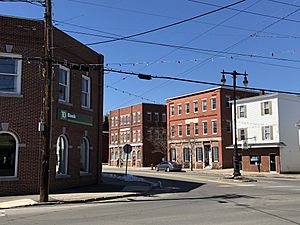
Intersection of Central and Main streets in Farmington
|
|
| Country | United States |
| State | New Hampshire |
| County | Strafford |
| Town | Farmington |
| Area | |
| • Total | 6.26 sq mi (16.21 km2) |
| • Land | 6.26 sq mi (16.21 km2) |
| • Water | 0.00 sq mi (0.00 km2) |
| Elevation | 285 ft (87 m) |
| Population
(2020)
|
|
| • Total | 3,824 |
| • Density | 611.16/sq mi (235.97/km2) |
| Time zone | UTC-5 (Eastern (EST)) |
| • Summer (DST) | UTC-4 (EDT) |
| ZIP code |
03835
|
| Area code(s) | 603 |
| FIPS code | 33-25940 |
| GNIS feature ID | 2378064 |
Farmington is a special area in New Hampshire, United States. It's called a census-designated place (CDP). This means it's a specific area that the government counts for population, even though it's part of a larger town. Farmington is the main village within the larger town of Farmington. It's located in Strafford County.
In 2020, about 3,824 people lived in the Farmington CDP. The entire town of Farmington had a population of 6,722 people.
Contents
Where is Farmington?
Farmington CDP is in the northern part of the town of Farmington. It sits in the valley of the Cocheco River. The land around it is mostly rural.
It shares borders with other towns:
- To the northeast, it's next to Milton.
- To the north, it borders Middleton.
- To the northwest, you'll find New Durham.
Several roads help define its edges. New Hampshire Route 11 forms part of its southwestern border. Pokamoonshine Brook is on the southern side. The Cocheco River, Chestnut Hill Road, and New Hampshire Route 75 make up part of its eastern border.
Main Roads in Farmington
- Route 11 goes southeast about 7 miles (11 km) to Rochester. It also goes northwest about 9 miles (14 km) to Alton.
- Route 75 runs through the center of Farmington. It's known as Central Street and Elm Street. This route leads northeast about 5 miles (8 km) to Milton.
- Route 153 is Farmington's Main Street. It heads north about 8 miles (13 km) to Union.
The Farmington CDP covers a total area of about 6.26 square miles (16.2 square kilometers). All of this area is land. The Cocheco River flows through the western and southern parts of the CDP. It continues southeast towards Rochester and Dover.
People of Farmington
| Historical population | |||
|---|---|---|---|
| Census | Pop. | %± | |
| 1950 | 2,285 | — | |
| 1960 | 2,241 | −1.9% | |
| 1970 | 2,884 | 28.7% | |
| 1980 | 3,284 | 13.9% | |
| 1990 | 3,567 | 8.6% | |
| 2000 | 3,468 | −2.8% | |
| 2010 | 3,885 | 12.0% | |
| 2020 | 3,824 | −1.6% | |
| U.S. Decennial Census | |||
In 2010, there were 3,885 people living in the Farmington CDP. They lived in 1,510 households. About 1,000 of these were families.
Most people in Farmington are white (about 96.4%). Smaller groups include African American, Native American, Asian, and Pacific Islander residents. About 0.9% of the population identified as Hispanic or Latino.
Households and Families
- About 34.8% of households had children under 18 living there.
- Many households (44.6%) were headed by married couples.
- About 15.0% had a female head of household without a husband present.
- Roughly 25.3% of households were made up of single individuals.
- About 9.1% of households had someone living alone who was 65 years old or older.
The average household had about 2.57 people. The average family had about 3.01 people.
Age and Income
- About 24.5% of residents were under 18 years old.
- About 11.5% were 65 years old or older.
- The average age of people in Farmington was 37.6 years.
Between 2011 and 2015, the estimated average yearly income for a household was about $36,136. For families, the average income was around $48,028. Some people and families in Farmington had lower incomes.
See also
 In Spanish: Farmington (condado de Strafford) para niños
 | Leon Lynch |
 | Milton P. Webster |
 | Ferdinand Smith |


