Lakeport, New Hampshire facts for kids
Quick facts for kids
Lakeport, New Hampshire
|
|
|---|---|

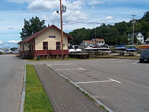
Lakeport railroad station, 2008
|
|
| Country | United States |
| State | New Hampshire |
| County | Belknap |
| City | Laconia |
| Elevation | 512 ft (156 m) |
| Time zone | UTC-5 (Eastern (EST)) |
| • Summer (DST) | UTC-4 (EDT) |
| Area code(s) | 603 |
| GNIS feature ID | 867926 |
Lakeport is a neighborhood located in the city of Laconia. It's in Belknap County, New Hampshire, in the United States. Long ago, it was known as "Lake Village."
Lakeport is special because it sits on a short river channel. This channel connects two parts of a larger lake system. To the north is Paugus Bay, which is an arm of Lake Winnipesaukee. To the south is Opechee Bay. A power dam is built on this channel. Lakeport is about 1.5 miles north of downtown Laconia.
Fun Things to Do in Lakeport
During the summer, you can catch a train ride in Lakeport! The Lakeport train station is the southern end of the Winnipesaukee Scenic Railroad. You can board these fun trains at Weirs Beach or Meredith to the north.
Lakeport used to be a very busy place for entertainment. Today, its main business area has a few convenience stores and several restaurants. There's also a large hotel right on Opechee Bay. You'll find a small post office and other local businesses too.
Over the past few years, Lakeport has been getting some cool upgrades. The main intersection was redesigned, and the Lakeport Bridge was replaced. New plants and foot bridges for walking have been added. These changes have helped new businesses open up. You can now find more places to stay, eat, and get different services.
There are two free public parks in Lakeport. They have both been rebuilt recently and feature brand new playground equipment. If you love boats, you're in luck! There are several boat launches and marinas on the Paugus Bay side of Lakeport.
Lakeport's Climate and Weather
Lakeport experiences a type of weather called a warm-summer humid continental climate. This means it has warm summers and cold, snowy winters. You can see more details about the weather in the chart below.
| Climate data for Lakeport, New Hampshire, 1991–2020 normals, extremes 1938–present | |||||||||||||
|---|---|---|---|---|---|---|---|---|---|---|---|---|---|
| Month | Jan | Feb | Mar | Apr | May | Jun | Jul | Aug | Sep | Oct | Nov | Dec | Year |
| Record high °F (°C) | 64 (18) |
69 (21) |
82 (28) |
92 (33) |
95 (35) |
96 (36) |
98 (37) |
100 (38) |
95 (35) |
85 (29) |
76 (24) |
69 (21) |
100 (38) |
| Mean maximum °F (°C) | 50.4 (10.2) |
52.8 (11.6) |
62.5 (16.9) |
77.7 (25.4) |
86.8 (30.4) |
90.9 (32.7) |
92.9 (33.8) |
91.0 (32.8) |
87.4 (30.8) |
76.3 (24.6) |
65.6 (18.7) |
54.1 (12.3) |
94.4 (34.7) |
| Mean daily maximum °F (°C) | 30.3 (−0.9) |
33.7 (0.9) |
42.5 (5.8) |
55.6 (13.1) |
68.0 (20.0) |
76.6 (24.8) |
82.1 (27.8) |
80.8 (27.1) |
73.3 (22.9) |
60.1 (15.6) |
47.3 (8.5) |
36.2 (2.3) |
57.2 (14.0) |
| Daily mean °F (°C) | 21.0 (−6.1) |
23.1 (−4.9) |
31.8 (−0.1) |
44.1 (6.7) |
56.3 (13.5) |
65.7 (18.7) |
71.3 (21.8) |
69.8 (21.0) |
62.4 (16.9) |
50.0 (10.0) |
38.7 (3.7) |
28.2 (−2.1) |
46.9 (8.3) |
| Mean daily minimum °F (°C) | 11.7 (−11.3) |
12.5 (−10.8) |
21.2 (−6.0) |
32.7 (0.4) |
44.5 (6.9) |
54.8 (12.7) |
60.4 (15.8) |
58.7 (14.8) |
51.5 (10.8) |
39.9 (4.4) |
30.0 (−1.1) |
20.2 (−6.6) |
36.5 (2.5) |
| Mean minimum °F (°C) | −5.8 (−21.0) |
−3.3 (−19.6) |
2.9 (−16.2) |
22.9 (−5.1) |
33.9 (1.1) |
44.6 (7.0) |
52.4 (11.3) |
49.7 (9.8) |
39.0 (3.9) |
29.2 (−1.6) |
17.6 (−8.0) |
4.2 (−15.4) |
−8.4 (−22.4) |
| Record low °F (°C) | −24 (−31) |
−17 (−27) |
−11 (−24) |
12 (−11) |
24 (−4) |
38 (3) |
45 (7) |
40 (4) |
30 (−1) |
23 (−5) |
4 (−16) |
−13 (−25) |
−24 (−31) |
| Average precipitation inches (mm) | 3.08 (78) |
2.88 (73) |
3.39 (86) |
3.65 (93) |
3.47 (88) |
4.44 (113) |
4.61 (117) |
3.89 (99) |
3.77 (96) |
4.83 (123) |
3.68 (93) |
3.92 (100) |
45.61 (1,159) |
| Average snowfall inches (cm) | 18.8 (48) |
16.9 (43) |
9.4 (24) |
1.6 (4.1) |
0.0 (0.0) |
0.0 (0.0) |
0.0 (0.0) |
0.0 (0.0) |
0.0 (0.0) |
0.3 (0.76) |
2.1 (5.3) |
12.8 (33) |
61.9 (158.16) |
| Average extreme snow depth inches (cm) | 11.3 (29) |
14.4 (37) |
11.8 (30) |
2.6 (6.6) |
0.0 (0.0) |
0.0 (0.0) |
0.0 (0.0) |
0.0 (0.0) |
0.0 (0.0) |
0.2 (0.51) |
1.4 (3.6) |
7.6 (19) |
14.4 (37) |
| Average precipitation days (≥ 0.01 in) | 11.7 | 9.2 | 10.8 | 11.2 | 12.1 | 12.6 | 11.4 | 10.0 | 9.8 | 11.2 | 10.7 | 11.6 | 132.3 |
| Average snowy days (≥ 0.1 in) | 7.4 | 6.0 | 4.0 | 0.8 | 0.0 | 0.0 | 0.0 | 0.0 | 0.0 | 0.1 | 1.0 | 4.9 | 24.2 |
| Source 1: NOAA | |||||||||||||
| Source 2: National Weather Service | |||||||||||||
 | Aaron Henry |
 | T. R. M. Howard |
 | Jesse Jackson |


