
Ayers Island Reservoir facts for kids
Quick facts for kids Ayers Island Reservoir |
|
|---|---|

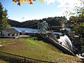
Ayers Island Dam
|
|

Ayers Island Reservoir
Location in New Hampshire

Ayers Island Reservoir
Location in the United States
|
|
| Location | Grafton County and Belknap County, New Hampshire |
| Coordinates | 43°35′52″N 71°43′04″W / 43.59778°N 71.71778°W |
| Type | Reservoir |
| Primary inflows | Pemigewasset River |
| Primary outflows | Pemigewasset River |
| Basin countries | United States |
| Max. length | 5.5 mi (8.9 km) |
| Max. width | 0.2 mi (0.32 km) |
| Surface elevation | 450 ft (140 m) |
| Settlements | Bristol New Hampton |
The Ayers Island Reservoir is a man-made lake located in the middle of New Hampshire, United States. It's found in two towns: Bristol and New Hampton. This reservoir was created by building a dam on the Pemigewasset River.
Contents
What is Ayers Island Reservoir?
Ayers Island Reservoir is an "impoundment." This means it's a body of water that has been held back by a dam. It's not a natural lake. Instead, it was formed to serve a purpose, often related to water supply or power generation.
Where is it located?
This reservoir is in central New Hampshire. It stretches across parts of two different counties: Grafton County and Belknap County, New Hampshire. The towns of Bristol and New Hampton are right next to its shores.
How big is it?
The Ayers Island Reservoir is about 5.5 miles long. That's like walking for over an hour! It's not very wide, only about 0.2 miles across. The water level is around 450 feet above sea level.
The Pemigewasset River
The Pemigewasset River is very important to the reservoir. It flows into the reservoir, bringing water from upstream. Then, the same river flows out of the reservoir, continuing its journey downstream. This means the reservoir is a part of the river's path.
Images for kids
-
Ayers Island Dam
