
New Hampton, New Hampshire facts for kids
Quick facts for kids
New Hampton, New Hampshire
|
|
|---|---|
|
Town
|
|

New Hampton Community Church
|
|

Location in Belknap County, New Hampshire
|
|
| Country | United States |
| State | New Hampshire |
| County | Belknap |
| Incorporated | 1777 |
| Area | |
| • Total | 38.4 sq mi (99.4 km2) |
| • Land | 36.8 sq mi (95.2 km2) |
| • Water | 1.6 sq mi (4.2 km2) 4.19% |
| Elevation | 525 ft (160 m) |
| Population
(2020)
|
|
| • Total | 2,377 |
| • Density | 65/sq mi (25.0/km2) |
| Time zone | UTC-5 (Eastern) |
| • Summer (DST) | UTC-4 (Eastern) |
| ZIP code |
03256
|
| Area code(s) | 603 |
| FIPS code | 33-51540 |
| GNIS feature ID | 0873679 |
New Hampton is a town in Belknap County, New Hampshire, USA. About 2,377 people lived there in 2020. It's known for winter sports and has the George Duncan State Forest. New Hampton is also home to the New Hampton School, a private school that helps students get ready for college. It was started in 1821.
The main village in town is called the New Hampton census-designated place. In 2020, 373 people lived in this village. You can find it along New Hampshire Route 132, just south of where it meets Route 104.
Contents
History of New Hampton
New Hampton was first given its land in 1765 by Governor Benning Wentworth. Back then, it was called "Moultonborough Addition." This name came from Colonel Jonathan Moulton, who was an important leader in the town.
In 1777, Colonel Moulton changed the name to New Hampton. He was born in a town called Hampton, which is why he chose the new name.
Important Institutions and Buildings
In 1821, the New Hampton School was founded in the town. It was started by a group called the Free Will Baptists. For a while, from 1854 to 1870, the school was connected with Cobb Divinity School. This divinity school later became part of Bates College.
Later, in 1920, the New Hampton Fish Hatchery was built. This is the oldest fish hatchery in the state of New Hampshire. It helps to raise fish for the state's waters.
Geography and Nature
New Hampton covers about 99.4 square kilometers (38.4 square miles) of land and water. Most of this area, about 95.2 square kilometers (36.8 square miles), is land. The rest, about 4.2 square kilometers (1.6 square miles), is water, making up about 4.19% of the town.
The Pemigewasset River forms the western and southwestern border of New Hampton. There are also several lakes in the town. Pemigewasset Lake is in the middle of New Hampton. Winona Lake and Lake Waukewan are located in the northeastern part of the town.
The highest point in New Hampton is on the west side of Hersey Mountain. This spot is about 1840 feet (561 meters) above sea level. The very top of Hersey Mountain, which is 2001 feet (610 meters) high, is just outside the town's border in Sanbornton.
Center of New Hampshire
Did you know that the exact middle of New Hampshire is located in New Hampton? It's in the eastern part of the town, between Winona Lake and Jackson Pond. The coordinates for this spot are 43.67925 N, 71.580375 W.
How to Get Around
New Hampton is easy to reach because Interstate 93 runs through it. This highway has an exit (Exit 23) in the town. Interstate 93 goes north towards Plymouth and south towards Concord.
Two state routes also pass through New Hampton: Route 104 and Route 132. Route 104 goes east and west, connecting Bristol to the west with Meredith to the east. Route 132 runs alongside Interstate 93 and connects New Hampton to towns like Sanbornton and Tilton to the south, and Ashland to the north.
Neighboring Towns
New Hampton shares its borders with several other towns:
- Ashland (to the north)
- Center Harbor (to the northeast)
- Meredith (to the east)
- Sanbornton (to the south)
- Hill (to the southwest)
- Bristol (to the west)
- Bridgewater (to the northwest)
People of New Hampton
| Historical population | |||
|---|---|---|---|
| Census | Pop. | %± | |
| 1790 | 652 | — | |
| 1800 | 1,095 | 67.9% | |
| 1810 | 1,293 | 18.1% | |
| 1820 | 1,500 | 16.0% | |
| 1830 | 1,904 | 26.9% | |
| 1840 | 1,812 | −4.8% | |
| 1850 | 1,612 | −11.0% | |
| 1860 | 1,596 | −1.0% | |
| 1870 | 1,257 | −21.2% | |
| 1880 | 1,059 | −15.8% | |
| 1890 | 935 | −11.7% | |
| 1900 | 852 | −8.9% | |
| 1910 | 821 | −3.6% | |
| 1920 | 708 | −13.8% | |
| 1930 | 692 | −2.3% | |
| 1940 | 791 | 14.3% | |
| 1950 | 723 | −8.6% | |
| 1960 | 862 | 19.2% | |
| 1970 | 946 | 9.7% | |
| 1980 | 1,249 | 32.0% | |
| 1990 | 1,606 | 28.6% | |
| 2000 | 1,950 | 21.4% | |
| 2010 | 2,165 | 11.0% | |
| 2020 | 2,377 | 9.8% | |
| U.S. Decennial Census | |||
In 2010, there were 2,165 people living in New Hampton. These people lived in 848 households, and 617 of these were families. Most of the people living in New Hampton (96.9%) were White. About 1.1% of the population was Hispanic or Latino.
About 22.5% of the people in town were under 18 years old. About 15.5% were 65 years old or older. The average age in New Hampton was 42.4 years.
The average yearly income for a household in New Hampton was about $74,009 between 2011 and 2015. For families, the average income was about $73,913. About 6.6% of the people and 3.3% of the families in New Hampton lived below the poverty line.
Education in New Hampton
New Hampton is part of the Newfound Area School District. The town has its own school, the New Hampton Community School. For older students, the district's middle school and high school are in Bristol. These are Newfound Memorial Middle School and Newfound Regional High School.
Places to Visit
New Hampton has several interesting historical sites and buildings:
- Dana Meeting House (built around 1800)
- Gordon-Nash Library (built around 1895)
- New Hampton Town House (built around 1798)
- New Hampton Community Church
Famous People from New Hampton
Many interesting people have connections to New Hampton:
- Mary W. Bacheler (1860–1939), a doctor and missionary who worked in India.
- Oliver Blake (1802–1873), a businessman and politician in Canada.
- Adoniram Judson Gordon (1836–1895), a minister who founded Gordon College.
- Orren C. Moore (1839–1893), who served as a US congressman.
- Simon W. Robinson (1792–1868), a soldier in the War of 1812 and a businessman.
- Darius Songaila (born 1978), a professional basketball player who attended New Hampton School.
- Ernest Thompson (born 1949), an author famous for the play On Golden Pond (he spends his summers here).
Images for kids
-
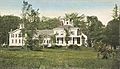
Lewis Mansion in 1909
-
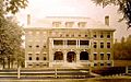
Berry Hall c. 1912
-
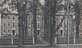
Randall Hall c. 1910
-
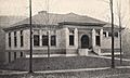
Gordon-Nash Library c. 1915


See also
 In Spanish: New Hampton (Nuevo Hampshire) para niños
