
Hill, New Hampshire facts for kids
Quick facts for kids
Hill, New Hampshire
|
|
|---|---|

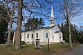
Hill Village Bible Church
|
|

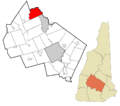
Location in Merrimack County and the state of New Hampshire
|
|
| Country | United States |
| State | New Hampshire |
| County | Merrimack |
| Incorporated | 1778 |
| Villages |
|
| Area | |
| • Total | 26.73 sq mi (69.23 km2) |
| • Land | 26.55 sq mi (68.77 km2) |
| • Water | 0.18 sq mi (0.46 km2) 0.66% |
| Elevation | 453 ft (138 m) |
| Population
(2020)
|
|
| • Total | 1,017 |
| • Density | 38/sq mi (14.8/km2) |
| Time zone | UTC-5 (Eastern) |
| • Summer (DST) | UTC-4 (Eastern) |
| ZIP codes |
03243 (Hill)
03230 (Danbury) |
| Area code(s) | 603 |
| FIPS code | 33-35860 |
| GNIS feature ID | 0873624 |
Hill is a small town located in Merrimack County, New Hampshire, in the United States. It's a type of community known as a New England town. In 2020, about 1,017 people lived here. Hill is also home to the beautiful William Thomas State Forest.
Contents
The Story of Hill: A Town's Past
How Hill Got Its Name
The town of Hill has an interesting history. It was first given land in 1753 and called "New Chester." Later, in 1837, the town changed its name to "Hill." This was done to honor Isaac Hill, who was the governor of New Hampshire from 1836 to 1839.
Moving the Town
Something very unusual happened in Hill in 1941. The original village of Hill had to be moved. This was because a large project, the Franklin Falls Dam, was being built. The dam needed a lot of space, so the entire village was relocated to a new spot.
Geography: Where Hill Is Located
Land and Water in Hill
Hill is a town with a mix of land and water. It covers about 69.2 square kilometers (about 26.7 square miles) in total. Most of this area, about 68.8 square kilometers (26.6 square miles), is land. The rest, about 0.5 square kilometers (0.2 square miles), is water. This means water makes up about 0.66% of the town's total area.
Rivers and Waterways
The Pemigewasset River forms the eastern border of Hill. A smaller river, the Smith River, flows into the Pemigewasset and makes up parts of Hill's northern border. Water from the southwestern part of town flows into the Blackwater River. All these rivers eventually lead to the Merrimack River. This means Hill is part of the large Merrimack River watershed.
Highest Point
The highest place in Hill is called Dickinson Hill. It stands about 1,910 feet (582 meters) above sea level.
Neighboring Towns
Hill is surrounded by several other towns. These include:
- Bristol (to the north)
- New Hampton (to the northeast)
- Sanbornton (to the east)
- Franklin (to the southeast)
- Andover (to the south)
- Danbury (to the west)
- Alexandria (to the northwest)
People of Hill: Population and Community
| Historical population | |||
|---|---|---|---|
| Census | Pop. | %± | |
| 1870 | 620 | — | |
| 1880 | 667 | 7.6% | |
| 1890 | 548 | −17.8% | |
| 1900 | 603 | 10.0% | |
| 1910 | 556 | −7.8% | |
| 1920 | 500 | −10.1% | |
| 1930 | 468 | −6.4% | |
| 1940 | 498 | 6.4% | |
| 1950 | 310 | −37.8% | |
| 1960 | 396 | 27.7% | |
| 1970 | 450 | 13.6% | |
| 1980 | 736 | 63.6% | |
| 1990 | 814 | 10.6% | |
| 2000 | 992 | 21.9% | |
| 2010 | 1,089 | 9.8% | |
| 2020 | 1,017 | −6.6% | |
| U.S. Decennial Census | |||
Population Changes Over Time
The number of people living in Hill has changed quite a bit over the years. In 1870, there were 620 residents. The population went up and down, reaching 1,089 people in 2010. By the 2020 census, the population was 1,017.
A Look at the Community in 2000
In the year 2000, there were 992 people living in Hill. They lived in 382 different homes. About 271 of these homes were families. The town had about 37 people per square mile.
Many homes (33%) had children under 18 living there. Most homes (57.9%) were married couples. About 21.2% of homes had just one person living in them. The average home had 2.60 people, and the average family had 3.01 people.
Age Groups in Hill
The people in Hill were of different ages. About 26.7% were under 18 years old. About 6.1% were between 18 and 24. The largest group, 31.3%, was between 25 and 44. People aged 45 to 64 made up 25.7%. Finally, 10.2% of the population was 65 or older. The average age in Hill was 39 years old.
Education: Learning in Hill
Hill has one school for younger students. It is called Jennie D. Blake Elementary School. This school teaches children from kindergarten up to sixth grade. The school was named after Jennie Lind Dickerson Blake, who was born in Hill in 1878. In 2017, about 68 students were enrolled at the school.
Notable People from Hill
- Augustus C. French (1808–1864) was born in Hill. He later became the ninth governor of Illinois.
Images for kids
-
Hill Village Bible Church
-
Location of Hill in Merrimack County
See also
 In Spanish: Hill (Nuevo Hampshire) para niños
