
Smith River (Pemigewasset River tributary) facts for kids
Quick facts for kids Smith River |
|
|---|---|

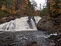
Profile Falls on the Smith River near Bristol, NH
|
|


|
|
| Country | United States |
| State | New Hampshire |
| Counties | Grafton, Merrimack |
| Towns | Grafton, Danbury, Alexandria, Hill, Bristol |
| Physical characteristics | |
| Main source | Tewksbury Pond Grafton 924 ft (282 m) 43°36′24″N 71°57′57″W / 43.60667°N 71.96583°W |
| River mouth | Pemigewasset River Bristol, Hill 310 ft (94 m) 43°33′49″N 71°43′40″W / 43.56361°N 71.72778°W |
| Length | 25.0 mi (40.2 km) |
The Smith River is a river in central New Hampshire, United States. It is about 25 miles (40 kilometers) long. This river flows into the Pemigewasset River. The Pemigewasset River is part of the larger Merrimack River watershed. A watershed is an area of land where all the water drains into a common river or lake.
Contents
Journey of the Smith River
The Smith River starts its journey at Tewksbury Pond in Grafton, New Hampshire. From there, it flows first southwest, then southeast. It passes through the town of Grafton and also goes through Kilton Pond.
River's Path Through Towns
As the river continues, it flows through Danbury. In this area, the river is mostly calm and flat. This changes when it gets closer to the border between Alexandria and Hill. Here, the river enters a narrow valley.
Exciting Whitewater and Falls
In the narrow valley, the Smith River creates several miles of exciting whitewater. Whitewater is a part of a river where the water moves very fast over rocks. This creates foamy, white rapids. The river then flows under the New Hampshire Route 3A bridge. This bridge is located near the border of Bristol and Hill.
Right after passing under the bridge, the Smith River drops over a beautiful waterfall called Profile Falls. After the falls, the Smith River quickly joins the larger Pemigewasset River.
Images for kids
-
Profile Falls on the Smith River near Bristol, NH
