Alexandria, New Hampshire facts for kids
Quick facts for kids
Alexandria, New Hampshire
|
|
|---|---|
|
Town
|
|

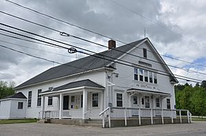
Town hall
|
|

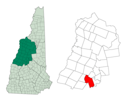
Location in Grafton County, New Hampshire
|
|
| Country | United States |
| State | New Hampshire |
| County | Grafton |
| Incorporated | 1782 |
| Area | |
| • Total | 43.4 sq mi (112.3 km2) |
| • Land | 43.2 sq mi (111.8 km2) |
| • Water | 0.2 sq mi (0.5 km2) 0.47% |
| Elevation | 623 ft (190 m) |
| Population
(2020)
|
|
| • Total | 1,776 |
| • Density | 41/sq mi (15.9/km2) |
| Time zone | UTC-5 (Eastern) |
| • Summer (DST) | UTC-4 (Eastern) |
| ZIP codes | |
| Area code(s) | 603 |
| FIPS code | 33-00580 |
| GNIS feature ID | 0873527 |
Alexandria is a small town in Grafton County, New Hampshire, United States. In 2020, about 1,776 people lived there. This was an increase from 1,613 people in 2010.
The town is known for its beautiful natural spots. Newfound Lake is in the northeast part of town. You can find Wellington State Park on its western shore. Alexandria is also home to Welton Falls State Forest. In the west, you'll find Cardigan Mountain State Park, which includes Mount Cardigan. Another interesting place is Mowglis Mountain. It was named after Mowgli, a character from Rudyard Kipling's famous book, Jungle Book.
Contents
History of Alexandria
How Alexandria Got Started
Alexandria was first given as a land grant in 1753 by a group called the Masonian Proprietors. The town was named after Alexandria, Virginia. This city was important because a meeting of governors happened there in 1755, early in the French and Indian War.
The land for Alexandria was officially given to Joseph Butterfield and others on March 13, 1757. The first settlers, John Moore Corliss and his brother Jonathan, arrived in 1769. The town officially became a town (was incorporated) by the New Hampshire General Court on November 23, 1782. Later, in 1795, the nearby town of Danbury was created from part of Alexandria.
Life in Early Alexandria
Even though some parts of Alexandria were mountainous, other areas had flat, fertile land perfect for farming. By 1859, Alexandria had a population of 1,273 people. Agriculture (farming) was the main job for many people. The town also had businesses like a carriage maker, nine sawmills for cutting wood, and three gristmills for grinding grain.
Famous People from Alexandria
Alexandria is the birthplace of Luther C. Ladd (1843–1861). He was the first enlisted soldier to die in the Civil War. He was shot during the Baltimore Riot.
Another famous person born here was Louise Lamprey (1869-1951). She was a writer who wrote many books especially for children.
Today, Alexandria is home to Cardigan Lodge. This is a facility run by the Appalachian Mountain Club and is located at the base of Mount Cardigan.
Geography of Alexandria
Alexandria is located in the central part of New Hampshire. It sits along the southern edge of Grafton County. The town covers about 112.3 square kilometers (about 43.4 square miles) in total. Most of this area, about 111.8 square kilometers (43.2 square miles), is land. The rest, about 0.5 square kilometers (0.2 square miles), is water.
Rivers and Mountains
The Fowler River flows through Alexandria, moving east towards Newfound Lake. The Smith River forms part of the town's southern border. All the water in Alexandria eventually flows into the Pemigewasset River. This river is part of the larger Merrimack River watershed, which means all the water in this area eventually drains into the Merrimack River.
Mount Cardigan is a tall mountain on the western edge of Alexandria. It is about 3,121 feet (951 meters) high. The very top of Mount Cardigan is actually in the nearby town of Orange. However, the highest point within Alexandria itself is on the Firescrew ridge to the north, reaching about 3,040 feet (927 meters).
Population and People
| Historical population | |||
|---|---|---|---|
| Census | Pop. | %± | |
| 1790 | 298 | — | |
| 1800 | 303 | 1.7% | |
| 1810 | 409 | 35.0% | |
| 1820 | 707 | 72.9% | |
| 1830 | 1,083 | 53.2% | |
| 1840 | 1,284 | 18.6% | |
| 1850 | 1,273 | −0.9% | |
| 1860 | 1,253 | −1.6% | |
| 1870 | 876 | −30.1% | |
| 1880 | 828 | −5.5% | |
| 1890 | 679 | −18.0% | |
| 1900 | 630 | −7.2% | |
| 1910 | 571 | −9.4% | |
| 1920 | 502 | −12.1% | |
| 1930 | 412 | −17.9% | |
| 1940 | 396 | −3.9% | |
| 1950 | 402 | 1.5% | |
| 1960 | 370 | −8.0% | |
| 1970 | 466 | 25.9% | |
| 1980 | 706 | 51.5% | |
| 1990 | 1,190 | 68.6% | |
| 2000 | 1,329 | 11.7% | |
| 2010 | 1,613 | 21.4% | |
| 2020 | 1,776 | 10.1% | |
| U.S. Decennial Census | |||
According to the census from 2000, there were 1,329 people living in Alexandria. These people lived in 504 households, and 386 of these were families.
The population was spread out by age. About 25% of the people were under 18 years old. About 11.3% were 65 years old or older. The average age in the town was 40 years. For every 100 females, there were about 99 males.
Education
Alexandria is part of the Newfound Area School District. Students in this district attend Newfound Memorial Middle School for middle school. For high school, they go to Newfound Regional High School in the nearby town of Bristol.
See also
 In Spanish: Alexandria (Nuevo Hampshire) para niños
 | Janet Taylor Pickett |
 | Synthia Saint James |
 | Howardena Pindell |
 | Faith Ringgold |


