Danbury, New Hampshire facts for kids
Quick facts for kids
Danbury, New Hampshire
|
|
|---|---|
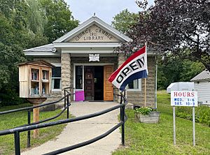
George Gamble Library
|
|
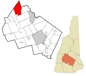
Location in Merrimack County and the state of New Hampshire.
|
|
| Country | United States |
| State | New Hampshire |
| County | Merrimack |
| Incorporated | 1795 |
| Villages |
|
| Area | |
| • Total | 38.0 sq mi (98.5 km2) |
| • Land | 37.7 sq mi (97.7 km2) |
| • Water | 0.3 sq mi (0.8 km2) 0.81% |
| Elevation | 825 ft (251 m) |
| Population
(2020)
|
|
| • Total | 1,250 |
| • Density | 33/sq mi (12.8/km2) |
| Time zone | UTC-5 (Eastern) |
| • Summer (DST) | UTC-4 (Eastern) |
| ZIP code |
03230
|
| Area code(s) | 603 |
| FIPS code | 33-16980 |
| GNIS feature ID | 0873574 |
Danbury is a small town located in Merrimack County, New Hampshire, United States. In 2020, about 1,250 people lived there. It's a quiet place with a rich history and beautiful natural areas.
Contents
History of Danbury
Danbury was first settled around 1771. At that time, it was part of a town called Alexandria. However, mountains made it hard to travel between Danbury and the rest of Alexandria.
Because of this, Danbury became its own town in 1795. A settler from Danbury, Connecticut suggested the name. Later, Danbury grew by adding land from nearby towns like Wilmot and Hill.
The land in Danbury is mostly hilly. But there are some good flat areas called "intervales" perfect for agriculture (farming). Raising cattle and sheep became the main jobs for people living there. By 1859, the town had 934 people. They also had seven sawmills, which cut wood. There were also mills for making shingles, lath, and clapboard. One tannery processed animal hides into leather.
Geography and Nature
Danbury covers about 98.5 square kilometers (38 square miles). Most of this is land, with a small part being water.
Rivers and Lakes
The Smith River flows through the middle of Danbury. It eventually joins the Pemigewasset River. Other streams like Walker Brook and Frazier Brook flow into the Blackwater River. All the water in Danbury eventually flows into the Merrimack River.
There are several beautiful bodies of water in town. These include Waukeena Lake, School Pond, and Bog Pond.
Mountains and Trails
The highest point in Danbury is Tinkham Hill, which is 2,320 feet (707 meters) above sea level. Ragged Mountain is another important mountain in the southern part of town. It has a popular ski area where people can ski in winter.
A hiking trail called the Sunapee-Ragged-Kearsarge Greenway crosses part of Danbury. You can find access to this trail from New Canada Road in Wilmot or from Proctor Academy in Andover.
Location and Roads
Danbury is about 35 miles (56 km) northwest of Concord, the state capital. It's also about 50 miles (80 km) northwest of Manchester, New Hampshire's biggest city. Danbury is the northernmost town in Merrimack County. It's also part of the Dartmouth-Lake Sunapee Region.
You can reach Danbury using U.S. Route 4 and New Hampshire Route 104.
Neighboring Towns
Danbury shares its borders with these towns:
- Alexandria (to the north)
- Hill (to the east)
- Andover (to the south)
- Wilmot (to the southwest)
- Grafton (to the west)
Population of Danbury
| Historical population | |||
|---|---|---|---|
| Census | Pop. | %± | |
| 1790 | 111 | — | |
| 1800 | 165 | 48.6% | |
| 1810 | 345 | 109.1% | |
| 1820 | 467 | 35.4% | |
| 1830 | 786 | 68.3% | |
| 1840 | 800 | 1.8% | |
| 1850 | 934 | 16.8% | |
| 1860 | 947 | 1.4% | |
| 1870 | 796 | −15.9% | |
| 1880 | 760 | −4.5% | |
| 1890 | 683 | −10.1% | |
| 1900 | 654 | −4.2% | |
| 1910 | 592 | −9.5% | |
| 1920 | 516 | −12.8% | |
| 1930 | 498 | −3.5% | |
| 1940 | 578 | 16.1% | |
| 1950 | 496 | −14.2% | |
| 1960 | 435 | −12.3% | |
| 1970 | 489 | 12.4% | |
| 1980 | 680 | 39.1% | |
| 1990 | 884 | 30.0% | |
| 2000 | 1,071 | 21.2% | |
| 2010 | 1,164 | 8.7% | |
| 2020 | 1,250 | 7.4% | |
| U.S. Decennial Census | |||
The first official count of people in Danbury was in 1800, when 165 people lived there. Over the years, the population has changed quite a bit. In 2020, the population was 1,250 people.
Who Lives in Danbury?
Based on the 2000 census, there were 1,071 people living in Danbury. Most residents were White.
There were 435 households in the town. About 31% of these households had children under 18 living with them. Many households were married couples living together.
The average age of people in Danbury in 2000 was 41 years old. About 23% of the population was under 18 years old.
Schools in Danbury
Danbury is part of the Newfound Area School District. Students in elementary school attend Danbury Elementary School. For middle and high school, students go to Newfound Memorial Middle School and Newfound Regional High School in Bristol.
Fun Places to Visit
- Ragged Mountain Resort: A great place for skiing in winter and golfing in summer.
- Danbury North Road Schoolhouse Museum: Learn about local history at this museum run by the Danbury Historical Society.
- Bog Pond Dam or Danbury Bog: A 100-acre (40 ha) area for recreation.
- Waukeena Lake: A 56-acre (23 ha) cold water lake. Motorboats have some rules here.
- School Pond: A 37-acre (15 ha) warm water pond, also with motorboat rules.
- Emily & Theodore Hope Forest: A large 375-acre (152 ha) forest protected by the Society for the Protection of New Hampshire Forests.
- Rosemary's Woods: Another 215-acre (87 ha) property also protected by the SPNHF.
- Independence Park: A town park with fields for different activities.
Famous People from Danbury
- Francis Reed (1852–1917): An inventor who created many machines for lathes and drills.
- Amos Leavitt Taylor: He was an important leader in the Massachusetts Republican Party for many years.
See also
 In Spanish: Danbury (Nuevo Hampshire) para niños
 | Isaac Myers |
 | D. Hamilton Jackson |
 | A. Philip Randolph |


