
Ragged Mountain (New Hampshire) facts for kids
Quick facts for kids Ragged Mountain |
|
|---|---|

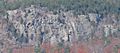
Ragged Mountain as seen from Mount Kearsarge
|
|
| Highest point | |
| Elevation | 2,286 ft (697 m) |
| Geography | |
| Location | Andover, New Hampshire, U.S. |
| Topo map | USGS Andover |
Ragged Mountain is a cool place in central New Hampshire. It's a mountain with many bumpy tops, located in the towns of Danbury and Andover. It stands about 2,286 feet (697 m) above sea level. This mountain is also home to the popular Ragged Mountain ski resort.
Contents
Exploring Ragged Mountain's Geography
Ragged Mountain is known for its rugged look. One writer, John R. Eastman, described it as a "truly ragged pile of ledge and boulder." It runs from east to west and has two main peaks. These peaks are separated by a small dip in the middle.
The Pinnacle and Ski Resort Peak
The highest point is called The Pinnacle. It is in Andover and reaches 2,286 feet (697 m) high. The second peak is at the top of the Ragged Mountain Ski Resort. This peak is in Danbury and is 2,225 feet (678 m) tall.
The Bulkhead Cliff
On the eastern side of Ragged Mountain, there's a huge granite cliff called The Bulkhead. It's about 300-foot (91 m) tall! This spot is sometimes used for rock climbing. It's also a special place because peregrine falcons used to nest here. These amazing birds are very fast flyers. You can reach The Bulkhead by hiking a trail from Proctor Academy's campus. The hike takes about an hour and twenty minutes from the Andover town green.
Hiking the SRK Greenway
A long hiking trail called the Sunapee–Ragged–Kearsarge (SRK) Greenway crosses Ragged Mountain. This trail is about 75-mile (120 km) long. You can start hiking from Proctor Academy on NH Route 11 in Andover. On the northern side, you can start from New Canada Road in Danbury.
Water Around Ragged Mountain
The water from Ragged Mountain flows in different directions.
Rivers and Watersheds
- Water from the northern side of the mountain flows into the Smith River.
- Water from the western, southern, and eastern sides goes into the Blackwater River.
All the water from Ragged Mountain eventually ends up in the Merrimack River. This river then flows into the Gulf of Maine (part of the Atlantic Ocean) near Newburyport, Massachusetts. This whole area is called the Merrimack River watershed.
Nearby Ponds
There are several ponds located around the base of Ragged Mountain. These include:
- Eagle Pond
- Cold Pond
- Hopkins Pond
- Elbow Pond
- Bog Pond
Images for kids
-
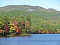
View of Ragged Mountain from Elbow Pond
-
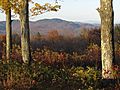
South side of Ragged Mountain from Winslow State Park
-
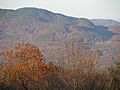
The Pinnacle (2,286 ft) and The Bulkhead (1600 ft)
-
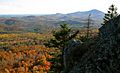
View of Mount Kearsarge from The Bulkhead on Ragged Mountain
-
The Bulkhead cliffs on Ragged Mountain
_east_side_from_Elbow_Pond.jpg)
.jpg)


