Mount Kearsarge (Merrimack County, New Hampshire) facts for kids
Quick facts for kids Mount Kearsarge |
|
|---|---|
| Carasarga | |

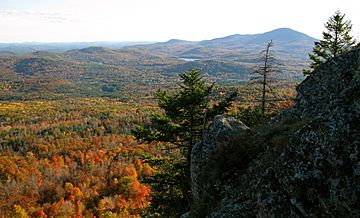
View of Mount Kearsarge from The Bulkhead on Ragged Mountain
|
|
| Highest point | |
| Elevation | 2,937 ft (895 m) |
| Prominence | 2,080 ft (630 m) |
| Geography | |
| Location | Merrimack County, New Hampshire, U.S. |
| Topo map | USGS Andover (NH) |
Mount Kearsarge is a mountain in New Hampshire, United States. It stands in the towns of Wilmot and Warner. This mountain is special because it has two state parks at its base: Winslow State Park to the north and Rollins State Park to the south. The whole mountain is part of the Kearsarge Mountain State Forest.
From the top of Mount Kearsarge, you can see really far on a clear day. You might even spot tall buildings in Boston, which is about 80 miles (129 km) away! The very top of the mountain has been bare, without many trees, since a big forest fire happened in 1796.
The name "Kearsarge" comes from an old word. In 1652, the native Pennacook tribe called it Carasarga. People think this name means "notch-pointed-mountain of pines."
Contents
What Makes Mount Kearsarge Special?
Mount Kearsarge is a type of mountain called a monadnock. This means it's a single mountain that stands alone, rising up from flat land around it. Even though it's not super tall compared to some other mountains, its isolation makes it stand out.
How Tall is Mount Kearsarge?
Mount Kearsarge is about 2,937 feet (895 meters) high. It rises about 2,100 feet (640 meters) above the lower land nearby. This makes it one of only twelve mountains in New Hampshire that rise more than 2,000 feet (610 meters) from their surroundings.
Where Does the Water Go?
Water flowing off Mount Kearsarge eventually reaches the Merrimack River. This river then flows into the Gulf of Maine in the Atlantic Ocean.
- Water from the western side of the mountain flows into Cascade Brook. This brook goes north to the Blackwater River.
- The Blackwater River flows around the north and east sides of Mount Kearsarge. It then joins the Contoocook River, which is a branch of the Merrimack River.
- Water from the southern side of the mountain goes into Meadow Brook. This brook flows into the Warner River, which also joins the Contoocook River.
Exploring Mount Kearsarge: Hiking Trails
Mount Kearsarge is a very popular place for hiking. It's part of a long hiking path called the Sunapee-Ragged-Kearsarge Greenway. This trail is about 75 miles (121 km) long. It connects 10 towns and goes around the Kearsarge-Lake Sunapee area of western New Hampshire.
Quickest Way to the Top
The fastest way to reach the summit is from Rollins State Park. This park has a picnic area on the mountain's south side. You can get there by driving on Kearsarge Mountain Road from the town of Warner.
Trails from Winslow State Park
You can also hike from the western side of the mountain, starting at the picnic area of Winslow State Park.
- The Winslow Trail is 1.1 miles (1.8 km) long.
- The Barlow Trail is 1.6 miles (2.6 km) long. This trail was built in 1997 by a volunteer group called Trailwrights.
The Full Greenway Hike
If you want a longer hike, the full Greenway section on Mount Kearsarge is about 5.8 miles (9.3 km). It starts from the Winslow picnic area, goes up the Barlow Trail to the summit, and then follows the Rollins and Lincoln trails southwest to Kearsarge Valley Road in North Sutton.
Who Was Winslow?
Both the Winslow Trail and Winslow State Park are named after Admiral John Ancrum Winslow. He was a naval commander during the American Civil War. In 1864, his ship, the USS Kearsarge, famously sank another ship called the CSS Alabama in the English Channel. The park is more directly named after a hotel that used to be there, called the Winslow House. The picnic grounds are now on the site where the hotel once stood.
 | DeHart Hubbard |
 | Wilma Rudolph |
 | Jesse Owens |
 | Jackie Joyner-Kersee |
 | Major Taylor |

