
Warner, New Hampshire facts for kids
Quick facts for kids
Warner, New Hampshire
|
||
|---|---|---|

Statue of Walter Harriman in the town center
|
||
|
||

Location in Merrimack County and the state of New Hampshire.
|
||
| Country | United States | |
| State | New Hampshire | |
| County | Merrimack | |
| Incorporated | 1774 | |
| Villages | ||
| Area | ||
| • Total | 55.48 sq mi (143.69 km2) | |
| • Land | 55.23 sq mi (143.04 km2) | |
| • Water | 0.25 sq mi (0.64 km2) 0.45% | |
| Elevation | 446 ft (136 m) | |
| Population
(2020)
|
||
| • Total | 2,937 | |
| • Density | 53/sq mi (20.5/km2) | |
| Time zone | UTC-5 (Eastern) | |
| • Summer (DST) | UTC-4 (Eastern) | |
| ZIP codes |
03278 (Warner)
03221 (Bradford) |
|
| Area code(s) | 603 | |
| FIPS code | 33-78580 | |
| GNIS feature ID | 0873745 | |

Warner is a small town in Merrimack County, New Hampshire, United States. In 2020, about 2,937 people lived there. This town is special because it's home to Magdalen College of the Liberal Arts, Rollins State Park, and part of Mount Kearsarge State Forest.
The main part of Warner, where most people live, is called the Warner census-designated place (CDP). It's located along New Hampshire Route 103 and the Warner River. Other small communities in the town include Davisville, Lower Village, Melvin Mills, and Waterloo.
Contents
Exploring Warner's Past
How Warner Got Its Name
The area was first given to settlers in 1735 by the governor of Massachusetts. It was called "Number One" and later "New Amesbury." This settlement was meant to help protect Massachusetts from attacks.
Later, in 1749, it was settled again and called "Jennesstown." But during the French and Indian War, the town was destroyed and abandoned. In 1767, it was granted once more and named "Amesbury." Finally, on September 3, 1774, it officially became "Warner." It was named after Jonathan Warner, an important person from Portsmouth. This was one of the last towns created before the American Revolution.
Growing as a Community
Warner became a successful farming town. People grew vegetables, hay, and apples, and raised animals for meat and dairy. The Warner River and its smaller streams provided power for many mills.
By 1832, Warner had twelve sawmills, six gristmills (for grinding grain), a paper mill, and two clothing factories. Later, there were also factories making cabinets, bottles, beds, chains, and woolen cloth. There was even an iron foundry, a tannery (for making leather), and a glove factory.
The Great Tornado of 1821
On September 9, 1821, a powerful tornado hit Warner. It tore through houses and forests for about 16 to 18 miles. The storm sadly killed four people in Warner and caused a lot of damage to buildings and property.
Celebrating Fall Foliage
Every October, during the Columbus Day weekend, Warner hosts its yearly Fall Foliage Festival. Thousands of people from all over New England and beyond come to enjoy the beautiful autumn leaves and the town's celebrations.
Discovering Warner's Landscape
Rivers, Bridges, and Mountains
Warner covers about 143.7 square kilometers (55.5 square miles). Most of the town's water flows into the Warner River, which runs right through the town center. Two historic covered bridges, the Dalton Bridge and the Waterloo Bridge, cross the river.
The highest point in Warner, and in all of Merrimack County, is Mount Kearsarge. It stands tall at 2,937 feet (895 meters) above sea level.
Parks and Hiking Trails
Mount Kearsarge is a popular spot for hiking. You can hike to its bare, rocky top, and there's even a paved road that goes almost to the summit from Rollins State Park.
Two state parks are located on the mountain: Rollins State Park in Warner and Winslow State Park in Wilmot. Mount Kearsarge is also part of the 75-mile Sunapee-Ragged-Kearsarge Greenway, a hiking trail that connects ten towns around Lake Sunapee.
Getting Around Warner
Major roads like Interstate 89 and New Hampshire Route 103 help people travel through Warner. Other state routes, 114 and 127, pass through the edges of the town.
Neighboring Towns
Warner is surrounded by several other towns:
- Andover (north)
- Salisbury (northeast)
- Webster (east)
- Hopkinton (southeast)
- Henniker (south)
- Bradford (west)
- Sutton (northwest)
- Wilmot (north-northwest)
People of Warner
Population Changes Over Time
| Historical population | |||
|---|---|---|---|
| Census | Pop. | %± | |
| 1790 | 863 | — | |
| 1800 | 1,569 | 81.8% | |
| 1810 | 1,838 | 17.1% | |
| 1820 | 2,246 | 22.2% | |
| 1830 | 2,222 | −1.1% | |
| 1840 | 2,159 | −2.8% | |
| 1850 | 2,038 | −5.6% | |
| 1860 | 1,970 | −3.3% | |
| 1870 | 1,667 | −15.4% | |
| 1880 | 1,537 | −7.8% | |
| 1890 | 1,383 | −10.0% | |
| 1900 | 1,358 | −1.8% | |
| 1910 | 1,226 | −9.7% | |
| 1920 | 1,051 | −14.3% | |
| 1930 | 1,062 | 1.0% | |
| 1940 | 1,113 | 4.8% | |
| 1950 | 1,080 | −3.0% | |
| 1960 | 1,004 | −7.0% | |
| 1970 | 1,441 | 43.5% | |
| 1980 | 1,963 | 36.2% | |
| 1990 | 2,250 | 14.6% | |
| 2000 | 2,760 | 22.7% | |
| 2010 | 2,833 | 2.6% | |
| 2020 | 2,937 | 3.7% | |
| U.S. Decennial Census | |||
In 2010, there were 2,833 people living in Warner. The town had 1,116 households, with many families living together. Most people in Warner are White (97.9%).
About 29% of households had children under 18. The average household had about 2.44 people. The median age in town was 44.5 years old. This means half the people were younger than 44.5, and half were older.
The Warner Area Farmers' Market is a popular place for the community to gather on Saturday mornings.
Fun Places to Visit in Warner

- New Hampshire Telephone Museum: Learn about old telephones!
- Dalton Covered Bridge: A historic bridge to see.
- Mount Kearsarge Indian Museum: Discover Native American history and culture.
- The Little Nature Museum: Explore local nature.
- Rollins State Park: Great for hiking and enjoying the outdoors.
- Warner Historical Society & Museum: Learn more about Warner's past.
- Kearsarge Mountain Community-Supported Agriculture: A place to get fresh, local food.
- Waterloo Covered Bridge: Another beautiful covered bridge.
Famous People from Warner
Many interesting people have connections to Warner:
- Caroline Gardner Bartlett (1868–1938): A music teacher and helper during World War I.
- Adelaide George Bennett (1848–1911): A poet and botanist (someone who studies plants).
- David Carroll (born 1942): A naturalist and author, known for studying nature.
- Rebecca Carroll (born 1969): An author, editor, and radio producer.
- H. Maria George Colby (1844–1910): An author and fashion editor.
- William C. Dowling (born 1944): A scholar and author.
- David Elliott (born 1947): A writer of books for children.
- Gordon Enoch Gates (1897–1987): A zoologist (someone who studies animals).
- Henry Gilmore (1832–1891): A businessman and state senator for Massachusetts.
- Walter Harriman (1817–1884): He was the 31st governor of New Hampshire.
- Amanda Bartlett Harris (1824–1917): An author and literary critic.
- Maxine Kumin (1925–2014): A famous poet.
- Nehemiah G. Ordway (1828–1907): He was the seventh governor of Dakota Territory.
- Jacob Osgood (1777–1844): A leader of a religious group.
- Charles Alfred Pillsbury (1842–1899): A businessman who helped start the Pillsbury Company, known for flour.
- John Sargent Pillsbury (1827–1901): He was the eighth governor of Minnesota.
- Charles Stuart Pratt (1854–1921): An editor and writer.
- Eliza Anna Farman Pratt (1837–1907): An editor and writer.
- Nellie George Stearns (1855–1936): An artist and art teacher.
Images for kids
-

Pillsbury Free Library around 1908
-
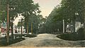
Main Street around 1908
-
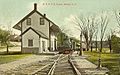
Boston & Maine Railroad depot in 1909
-
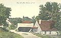
Old Mill in 1907


See also
 In Spanish: Warner (Nuevo Hampshire) para niños
