Salisbury, New Hampshire facts for kids
Quick facts for kids
Salisbury, New Hampshire
|
||
|---|---|---|

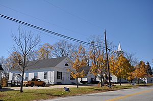
Old town hall and church (now historic society)
|
||
|
||

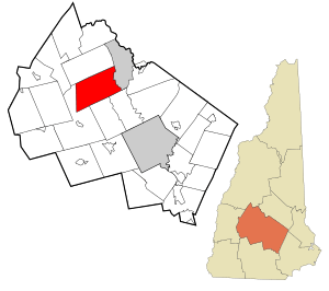
Location in Merrimack County and the state of New Hampshire
|
||
| Country | United States | |
| State | New Hampshire | |
| County | Merrimack | |
| Incorporated | 1768 | |
| Villages | Salisbury Salisbury Heights West Salisbury |
|
| Area | ||
| • Total | 39.8 sq mi (103.1 km2) | |
| • Land | 39.6 sq mi (102.5 km2) | |
| • Water | 0.2 sq mi (0.6 km2) 0.56% | |
| Elevation | 819 ft (250 m) | |
| Population
(2020)
|
||
| • Total | 1,422 | |
| • Density | 36/sq mi (13.9/km2) | |
| Time zone | UTC−5 (Eastern) | |
| • Summer (DST) | UTC−4 (Eastern) | |
| ZIP codes | ||
| Area code(s) | 603 | |
| FIPS code | 33-66980 | |
| GNIS feature ID | 0873714 | |
Salisbury is a small town located in Merrimack County, New Hampshire, in the United States. In 2020, about 1,422 people lived there.
Contents
History of Salisbury
Salisbury has a long history, starting even before New Hampshire was its own state.
Early Names and Settlement
Back in 1736, when this area was still part of Massachusetts, the town was first called "Baker's Town." This name honored Captain Thomas Baker.
Later, the border between Massachusetts and New Hampshire was officially set. Baker's Town ended up on the New Hampshire side. In 1749, new owners, called the Masonian proprietors, re-granted the land. They named it "Stevenstown" after Colonel Ebenezer Stevens. People started settling here around 1750.
Becoming Salisbury
The town was also known by other names like "Gerrishtown" and "New Salisbury." Finally, in 1768, the town officially became "Salisbury" when it was incorporated. This means it became an official town with its own local government.
Geography of Salisbury
Salisbury is a beautiful area with rivers and hills.
Land and Water
The town covers a total area of about 103.1 square kilometers (about 39.8 square miles). Most of this is land, with only a small part (about 0.6 square kilometers or 0.2 square miles) being water. Water makes up about 0.56% of the town's total area.
Mountains and Rivers
The highest point in Salisbury is on its western edge. Here, the eastern slopes of Mount Kearsarge rise to about 582 meters (1,910 feet) above sea level. Sea level is the average height of the ocean's surface.
The Blackwater River flows through the western part of Salisbury. This river flows south and eventually joins the Contoocook River, which then flows into the larger Merrimack River. The Merrimack River watershed is the area of land where all the water drains into the Merrimack River.
A popular spot for fishing and other fun activities is "The Bay." This is a natural, lake-like part of the Blackwater River. On the eastern side of Salisbury, smaller streams flow directly into the Merrimack River.
Neighboring Towns
Salisbury shares its borders with several other towns:
- Andover to the north
- Franklin to the northeast
- Boscawen to the southeast
- Webster to the south
- Warner to the southwest
Population Changes in Salisbury
The number of people living in Salisbury has changed a lot over the years.
| Historical population | |||
|---|---|---|---|
| Census | Pop. | %± | |
| 1790 | 1,372 | — | |
| 1800 | 1,767 | 28.8% | |
| 1810 | 1,913 | 8.3% | |
| 1820 | 2,016 | 5.4% | |
| 1830 | 1,379 | −31.6% | |
| 1840 | 1,332 | −3.4% | |
| 1850 | 1,228 | −7.8% | |
| 1860 | 1,191 | −3.0% | |
| 1870 | 897 | −24.7% | |
| 1880 | 795 | −11.4% | |
| 1890 | 655 | −17.6% | |
| 1900 | 604 | −7.8% | |
| 1910 | 478 | −20.9% | |
| 1920 | 390 | −18.4% | |
| 1930 | 350 | −10.3% | |
| 1940 | 368 | 5.1% | |
| 1950 | 423 | 14.9% | |
| 1960 | 415 | −1.9% | |
| 1970 | 589 | 41.9% | |
| 1980 | 781 | 32.6% | |
| 1990 | 1,061 | 35.9% | |
| 2000 | 1,137 | 7.2% | |
| 2010 | 1,382 | 21.5% | |
| 2020 | 1,422 | 2.9% | |
| U.S. Decennial Census | |||
In 2000, there were 1,137 people living in Salisbury. These people lived in 435 households, and 324 of these were families. The average household had about 2.6 people.
About 24.5% of the population was under 18 years old. The median age, which is the middle age of all the people, was 40 years old.
Notable People from Salisbury
Several important people have connections to Salisbury:
- Ichabod Bartlett (1786–1853): He was a US congressman.
- Samuel E. Pingree (1832–1922): He was an officer in the Union Army during the American Civil War and received the Medal of Honor. He also served as the 40th governor of Vermont.
- Ezekiel A. Straw (1819–1882): He was an engineer and businessman who became the 34th governor of New Hampshire.
- Daniel Webster (1782–1852): A very famous American statesman, he was a US congressman and senator from Massachusetts. He also served as the 14th and 19th US Secretary of State. He was born in 1782 in what was then part of Salisbury, but that area is now within the city of Franklin.
See also
 In Spanish: Salisbury (Nuevo Hampshire) para niños
 | Precious Adams |
 | Lauren Anderson |
 | Janet Collins |


