
Franklin, New Hampshire facts for kids
Quick facts for kids
Franklin, New Hampshire
|
||
|---|---|---|
|
City
|
||

Central Street
|
||
|
||
| Motto(s):
"The Three Rivers City"
|
||

Location within Merrimack County, and the state of New Hampshire.
|
||
| Country | United States | |
| State | New Hampshire | |
| County | Merrimack | |
| Settled | 1764 | |
| Incorporated (Town) | 1828 | |
| Area | ||
| • Total | 29.17 sq mi (75.55 km2) | |
| • Land | 27.43 sq mi (71.05 km2) | |
| • Water | 1.74 sq mi (4.50 km2) 5.95% | |
| Elevation | 310 ft (90 m) | |
| Population
(2020)
|
||
| • Total | 8,741 | |
| • Density | 318.63/sq mi (123.03/km2) | |
| Time zone | UTC−5 (EST) | |
| • Summer (DST) | UTC−4 (EDT) | |
| ZIP code |
03235
|
|
| Area code(s) | 603 | |
| FIPS code | 33-27380 | |
| GNIS feature ID | 0873290 | |

Franklin is a city in Merrimack County, New Hampshire, United States. It's known as "The Three Rivers City" because three important rivers meet there. In 2020, about 8,741 people lived in Franklin. This makes it the smallest of New Hampshire's 13 cities. The city also includes a small area called West Franklin.
Contents
History of Franklin: From Village to City
Franklin is located where the Pemigewasset and Winnipesaukee rivers join to form the Merrimack River. This area was first settled by European colonists in 1764. It was originally called "Pemigewasset Village."
The land for the village came from parts of nearby towns like Salisbury, Andover, Sanbornton, and Northfield. In 1820, the village was renamed "Franklin." This was done to honor Benjamin Franklin, a very important statesman and one of America's founding fathers.
The strong flow of water from the Winnipesaukee River's falls helped Franklin grow. It became a busy mill town, where factories used water power to run their machines. Franklin officially became a town in 1828 and then a city in 1895.
Famous People and Flood Control
Daniel Webster, a famous speaker and politician, was born in a part of Franklin that used to be part of Salisbury. You can visit his childhood home at the Daniel Webster Birthplace State Historic Site off Route 127. As an adult, Webster owned a farm called "The Elms" near the Merrimack River.
In 1943, the Army Corps of Engineers built the Franklin Falls Dam on the Pemigewasset River. This dam created the Franklin Falls Reservoir. Its main purpose is to control floods and protect the area from too much water.
Geography: Rivers, Lakes, and Roads
Franklin is located in the northern part of Merrimack County. It covers a total area of about 29.17 square miles (75.5 square kilometers). Most of this area, about 27.43 square miles (71.1 square kilometers), is land. The rest, about 1.74 square miles (4.5 square kilometers), is water.
The city is shaped by its rivers: the Winnipesaukee, Pemigewasset, and Merrimack. Webster Lake is also located in the northern part of Franklin. The highest point in the city is a hill in the northwest, which is about 1,370 feet (418 meters) above sea level. All the water in Franklin eventually flows into the Merrimack River watershed.
Main Roads in Franklin
The main street in Franklin is Central Street, which is formed by U.S. Route 3 and New Hampshire Route 11.
- If you head east on these routes, you'll reach Tilton and Laconia.
- US 3 goes south to Boscawen and Concord.
- NH 11 goes west to Andover and New London.
- New Hampshire Route 127 also goes through downtown Franklin, leading southwest to Salisbury and Contoocook, and north into Sanbornton.
- New Hampshire Route 3A heads north from West Franklin to Bristol.
Neighboring Towns and Cities
Franklin shares its borders with several other towns:
- Sanbornton (to the northeast)
- Tilton (to the east)
- Northfield (to the southeast)
- Boscawen (to the south)
- Salisbury (to the southwest)
- Andover (to the west)
- Hill (to the northwest)
Climate: Weather in Franklin
Franklin experiences a varied climate throughout the year. The weather box below shows the average temperatures and rainfall for the area.
| Climate data for Franklin Falls Dam (1991-2020 normals, extremes 1971-2023, coordinates:43°28′13″N 71°39′13″W / 43.4703°N 71.6536°W) | |||||||||||||
|---|---|---|---|---|---|---|---|---|---|---|---|---|---|
| Month | Jan | Feb | Mar | Apr | May | Jun | Jul | Aug | Sep | Oct | Nov | Dec | Year |
| Record high °F (°C) | 63 (17) |
70 (21) |
81 (27) |
92 (33) |
94 (34) |
98 (37) |
100 (38) |
101 (38) |
93 (34) |
85 (29) |
76 (24) |
68 (20) |
101 (38) |
| Mean maximum °F (°C) | 49 (9) |
52 (11) |
60 (16) |
81 (27) |
87 (31) |
89 (32) |
91 (33) |
90 (32) |
86 (30) |
74 (23) |
64 (18) |
52 (11) |
91 (33) |
| Mean daily maximum °F (°C) | 29.7 (−1.3) |
33.1 (0.6) |
41.9 (5.5) |
55.7 (13.2) |
67.7 (19.8) |
76.1 (24.5) |
81.8 (27.7) |
79.6 (26.4) |
71.7 (22.1) |
59.1 (15.1) |
45.8 (7.7) |
34.7 (1.5) |
56.4 (13.6) |
| Daily mean °F (°C) | 19.3 (−7.1) |
21.7 (−5.7) |
30.9 (−0.6) |
43.2 (6.2) |
55.2 (12.9) |
64.2 (17.9) |
69.9 (21.1) |
67.8 (19.9) |
59.9 (15.5) |
48.2 (9.0) |
36.1 (2.3) |
25.8 (−3.4) |
45.2 (7.3) |
| Mean daily minimum °F (°C) | 8.8 (−12.9) |
10.2 (−12.1) |
19.8 (−6.8) |
30.7 (−0.7) |
42.7 (5.9) |
52.2 (11.2) |
57.9 (14.4) |
55.9 (13.3) |
48.1 (8.9) |
37.2 (2.9) |
26.4 (−3.1) |
16.9 (−8.4) |
33.9 (1.0) |
| Mean minimum °F (°C) | −10 (−23) |
−7 (−22) |
2 (−17) |
19 (−7) |
28 (−2) |
38 (3) |
48 (9) |
45 (7) |
32 (0) |
22 (−6) |
12 (−11) |
0 (−18) |
−10 (−23) |
| Record low °F (°C) | −30 (−34) |
−24 (−31) |
−18 (−28) |
8 (−13) |
16 (−9) |
31 (−1) |
37 (3) |
31 (−1) |
12 (−11) |
11 (−12) |
−6 (−21) |
−21 (−29) |
−30 (−34) |
| Average precipitation inches (mm) | 3.13 (80) |
2.80 (71) |
3.31 (84) |
3.49 (89) |
3.62 (92) |
4.28 (109) |
4.20 (107) |
4.07 (103) |
3.72 (94) |
4.93 (125) |
3.93 (100) |
3.99 (101) |
45.47 (1,155) |
| Average snowfall inches (cm) | 19.0 (48) |
17.0 (43) |
11.9 (30) |
2.6 (6.6) |
0.1 (0.25) |
0.0 (0.0) |
0.0 (0.0) |
0.0 (0.0) |
0.0 (0.0) |
0.1 (0.25) |
4.4 (11) |
18.7 (47) |
73.8 (186.1) |
| Average extreme snow depth inches (cm) | 20 (51) |
23 (58) |
21 (53) |
7 (18) |
0 (0) |
0 (0) |
0 (0) |
0 (0) |
0 (0) |
0 (0) |
3 (7.6) |
12 (30) |
23 (58) |
| Average snowy days (≥ 0.1 in) | 7 | 6 | 4 | 1 | 0 | 0 | 0 | 0 | 0 | 0 | 2 | 6 | 26 |
| Source: NOAA, (snow data for 1960-1991, extremes) | |||||||||||||
Demographics: Who Lives in Franklin?
| Historical population | |||
|---|---|---|---|
| Census | Pop. | %± | |
| 1830 | 1,370 | — | |
| 1840 | 1,281 | −6.5% | |
| 1850 | 1,251 | −2.3% | |
| 1860 | 1,600 | 27.9% | |
| 1870 | 2,301 | 43.8% | |
| 1880 | 3,265 | 41.9% | |
| 1890 | 4,085 | 25.1% | |
| 1900 | 5,846 | 43.1% | |
| 1910 | 6,132 | 4.9% | |
| 1920 | 6,318 | 3.0% | |
| 1930 | 6,576 | 4.1% | |
| 1940 | 6,749 | 2.6% | |
| 1950 | 6,552 | −2.9% | |
| 1960 | 6,742 | 2.9% | |
| 1970 | 7,292 | 8.2% | |
| 1980 | 7,901 | 8.4% | |
| 1990 | 8,304 | 5.1% | |
| 2000 | 8,405 | 1.2% | |
| 2010 | 8,477 | 0.9% | |
| 2020 | 8,741 | 3.1% | |
| U.S. Decennial Census 1767-1786: NH Provincial & State Papers |
|||
In 2010, there were 8,477 people living in Franklin. These people made up 3,407 households, with 2,179 of them being families. A household is a group of people living together, and a family is a group related by blood, marriage, or adoption.
Most of the people in Franklin (96.2%) were white. Other groups included African American (0.5%), Native American (0.5%), and Asian (0.8%). About 1.6% of the population identified as Hispanic or Latino.
About 30.8% of households had children under 18 living with them. The average household had 2.43 people, and the average family had 2.93 people. The median age in the city was 40.2 years old. This means half the people were younger than 40.2, and half were older.
From 2011 to 2015, the estimated average yearly income for a household was about $43,237. For families, it was about $52,390. The per capita income (income per person) for the city was $22,318. About 21.1% of all people and 16.6% of families lived below the poverty line. This means their income was below a certain level set by the government.
Education: Schools in Franklin
Franklin has several schools for students:
- Franklin High School
- Franklin Middle School
- Paul Smith Elementary School
Sites of Interest: Places to Visit
If you visit Franklin, here are some interesting places:
- Sulphite Railroad Bridge (also known as the "upside-down" railroad bridge)
- Daniel Webster Birthplace State Historic Site
Notable People from Franklin
Many interesting people have connections to Franklin:
- Jedh Barker (1945–1967), a U.S. Marine who received the Medal of Honor after he died.
- Vaughn Blanchard (1889–1969), an Olympic track and field athlete.
- Cornelia James Cannon (1876–1969), a reformer who supported women's rights.
- Walter Bradford Cannon (1871–1945), a physiologist (someone who studies how living things work).
- Warren F. Daniell (1826–1913), a manufacturer, banker, and U.S. congressman.
- Ram Dass (1931–2019), a spiritual leader who sometimes lived in Franklin.
- John King Fairbank (1907–1991), a historian who spent summers in Franklin.
- Robert Moller Gilbreth (1920–2007), a New Hampshire state legislator, educator, and businessman.
- Robert M. Leach (1879–1952), a U.S. congressman.
- G. W. Pierce (1872–1956), a physics professor at Harvard University and inventor in telecommunications.
- Katherine Call Simonds (1865–1946), a musician, singer, author, and composer.
- Daniel Webster (1782–1852), a very important politician who served as Secretary of State, U.S. senator, and congressman.
Images for kids
-
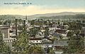
A view of Franklin from above around 1912.
-
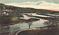
The Merrimack River in Franklin in 1905.
-
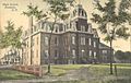
Franklin's Old High School in 1908.
-
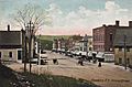
Central Street, the main road, in 1909.
-
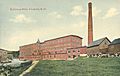
The Sulloway Mills, a factory, around 1910.
-
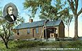
The birthplace of Daniel Webster around 1910.
-
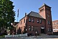
Franklin City Hall.
-
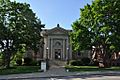
The Franklin Public Library, a Carnegie library, around 1915.


See also
 In Spanish: Franklin (Nuevo Hampshire) para niños
