
Contoocook, New Hampshire facts for kids
Quick facts for kids
Contoocook, New Hampshire
|
|
|---|---|

Contoocook Railroad Depot
|
|
| Nickname(s):
Tooky
|
|

Location in Merrimack County and the state of New Hampshire.
|
|
| Country | United States |
| State | New Hampshire |
| County | Merrimack |
| Town | Hopkinton |
| Area | |
| • Total | 2.40 sq mi (6.22 km2) |
| • Land | 2.30 sq mi (5.96 km2) |
| • Water | 0.10 sq mi (0.27 km2) |
| Elevation | 364 ft (111 m) |
| Population
(2020)
|
|
| • Total | 1,427 |
| • Density | 620.17/sq mi (239.48/km2) |
| Time zone | UTC-5 (Eastern (EST)) |
| • Summer (DST) | UTC-4 (EDT) |
| ZIP Code |
03229
|
| Area code(s) | 603 |
| FIPS code | 33-14340 |
| GNIS feature ID | 0866311 |
Contoocook (![]() i/kənˈtʊkək/) is a small village in New Hampshire, United States. It is part of the town of Hopkinton in Merrimack County. In 2020, about 1,427 people lived there.
i/kənˈtʊkək/) is a small village in New Hampshire, United States. It is part of the town of Hopkinton in Merrimack County. In 2020, about 1,427 people lived there.
Contoocook is known for its many small businesses. It also works hard to protect its old buildings and history. The village has a strong community spirit and offers many fun activities.
Contents
History of Contoocook

The village gets its name from the Contoocook River that flows through it. The name "Contoocook" comes from Native American tribes. It might mean "place of the river near pines" or "nut trees river." Long ago, people sometimes called the area "Contoocookville."
A famous person from Contoocook was George H. Perkins. He was a naval officer during the American Civil War. His daughter, Isabel Weld Perkins, and her husband, Larz Anderson, owned a large house called Perkins Manor here. It was one of their summer homes.
Where is Contoocook Located?
Contoocook is in the northern part of Hopkinton town. Main Street and Park Avenue are the main roads, which are part of New Hampshire Route 103. Another road, New Hampshire Route 127, also goes through the village.
Interstate 89 runs along the west side of Contoocook. This highway can take you to Concord, the state capital, or further north to Lebanon.
The village covers about 2.4 square miles (6.22 square kilometers). Most of this area is land, but a small part is water. The Contoocook River flows right through the middle of the village. The Warner River also flows into the Contoocook River at the northern edge of the community.
Who Lives in Contoocook?
| Historical population | |||
|---|---|---|---|
| Census | Pop. | %± | |
| 1980 | 1,499 | — | |
| 1990 | 1,334 | −11.0% | |
| 2000 | 1,444 | 8.2% | |
| 2010 | 1,444 | 0.0% | |
| 2020 | 1,427 | −1.2% | |
| U.S. Decennial Census | |||
In 2010, there were 1,444 people living in Contoocook. There were 610 households, which are groups of people living together.
Most people living in Contoocook are white (about 97.9%). A small number of people are from other racial backgrounds. About 1.2% of the population identified as Hispanic or Latino.
About 30% of households had children under 18 living with them. Many households (52.1%) were married couples. The average household had about 2.37 people.
The median age in Contoocook in 2010 was 45 years old. This means half the people were younger than 45, and half were older.
Places to See

You can find interesting places to visit in Contoocook. For more details, you can look at the main article for Hopkinton, New Hampshire.
Famous People from Contoocook
To learn about famous people connected to Contoocook, check out the article for Hopkinton, New Hampshire.
Images for kids
-
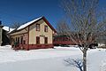
Contoocook Railroad Depot
-
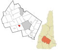
Location in Merrimack County and the state of New Hampshire.
See also
 In Spanish: Contoocook (Nuevo Hampshire) para niños
