
Lebanon, New Hampshire facts for kids
Quick facts for kids
Lebanon, New Hampshire
|
||
|---|---|---|

Buildings along Park Street in downtown Lebanon
|
||
|
||

Location in Grafton County, New Hampshire
|
||

Lebanon, New Hampshire
Location in the United States
|
||
| Country | United States | |
| State | New Hampshire | |
| County | Grafton | |
| Incorporated | 1761 | |
| City | 1958 | |
| Population centers | Lebanon East Wilder Mascoma West Lebanon |
|
| Area | ||
| • Total | 41.27 sq mi (106.90 km2) | |
| • Land | 40.30 sq mi (104.39 km2) | |
| • Water | 0.97 sq mi (2.51 km2) 2.35% | |
| Elevation | 581 ft (177 m) | |
| Population
(2020)
|
||
| • Total | 14,282 | |
| • Density | 354.35/sq mi (136.81/km2) | |
| • μSA | 223,471 | |
| Time zone | UTC-5 (Eastern) | |
| • Summer (DST) | UTC-4 (Eastern) | |
| ZIP codes |
03756, 03766 (Lebanon)
03784 (West Lebanon) |
|
| Area code(s) | 603 | |
| FIPS code | 33-41300 | |
| GNIS feature ID | 0867976 | |

Lebanon (/ˈlɛbənən/ leb-ƏN-ən) is a city in Grafton County, New Hampshire, United States. It's the only city in that county. In 2020, about 14,282 people lived there. Lebanon is in western New Hampshire, close to the Connecticut River. It's home to a big medical center, Dartmouth–Hitchcock Medical Center, and Dartmouth College's Geisel School of Medicine. These are the largest medical facilities between Boston, Massachusetts, and Burlington, Vermont.
Lebanon is a main city in the Lebanon–Claremont micropolitan area. This area includes four counties in the upper Connecticut River valley, two in New Hampshire and two in Vermont.
Contents
Discovering Lebanon's Past
Lebanon became a town on July 4, 1761. This was decided by colonial governor Benning Wentworth. It was one of 16 towns created along the Connecticut River. The town was named after Lebanon, Connecticut. Many early settlers, like Rev. Eleazar Wheelock, came from there. Wheelock arrived in 1770 and started Dartmouth College. The college actually began as Moor's Charity School in Lebanon, Connecticut.
Early settlers first lived near the Connecticut River in what is now West Lebanon. They also settled near Mascoma Lake by Enfield. In the mid-1800s, a mill area grew around the Mascoma River. Factories there made furniture, leather, and textiles. There were also machine shops and clothing factories. Many French workers from Canada's Quebec province moved here to work in these mills. This area became the center of town. West Lebanon also grew into a busy railroad hub.
The mills and railroad became less important in the 1950s and 1960s. The town had two big fires. The second fire, in 1964, destroyed much of the old mill area. After this, a new shopping area called The Mall was built. To help the town grow and to stop West Lebanon from becoming its own town, Lebanon officially became a city in 1958.
The building of Interstates 89 and 91 helped Lebanon's economy. The growth of Dartmouth College also brought new life to the area. Today, Lebanon's economy is based on education, medical services, and technology. A large shopping area is located in West Lebanon. The city has also improved its parks and trails. It has a municipal ski area, a swimming pool, and sports fields.
In 1991, the Dartmouth–Hitchcock Medical Center moved to a new campus near Lebanon. Many medical and high-tech companies have opened offices nearby. TomTom, a company that makes maps, has its North American office in Lebanon. Novo Nordisk and Microsoft also have facilities here.
Exploring Lebanon's Geography
Lebanon covers about 41.27 square miles (106.9 square kilometers). About 40.30 square miles (104.4 square kilometers) are land. The rest is water, mostly the Connecticut River. The Connecticut River forms Lebanon's western border with Vermont. West Lebanon is in the western part of the city, along this river. Downtown Lebanon is about 3 miles (5 km) east, along the Mascoma River. This river flows into the Connecticut River.
The city is part of the Connecticut River watershed. The southern part of Moose Mountain is in the northeast. The highest point in Lebanon is Shaker Mountain. It is 1,657 feet (505 meters) above sea level.
Lebanon's Climate
Lebanon has a warm-summer humid continental climate. This means it has warm summers and cold, snowy winters. The hottest temperature ever recorded in Lebanon was 99°F (37°C). This happened on June 18, 1957, and July 20, 1977. The coldest temperature was -34°F (-37°C) on January 14, 1957.
| Climate data for Lebanon, New Hampshire, 1991–2020 normals, extremes 1948–present | |||||||||||||
|---|---|---|---|---|---|---|---|---|---|---|---|---|---|
| Month | Jan | Feb | Mar | Apr | May | Jun | Jul | Aug | Sep | Oct | Nov | Dec | Year |
| Record high °F (°C) | 67 (19) |
68 (20) |
85 (29) |
91 (33) |
96 (36) |
99 (37) |
99 (37) |
98 (37) |
95 (35) |
87 (31) |
80 (27) |
69 (21) |
99 (37) |
| Mean maximum °F (°C) | 50.9 (10.5) |
52.0 (11.1) |
62.7 (17.1) |
80.5 (26.9) |
88.3 (31.3) |
91.8 (33.2) |
92.9 (33.8) |
90.8 (32.7) |
88.0 (31.1) |
77.4 (25.2) |
65.8 (18.8) |
55.2 (12.9) |
94.7 (34.8) |
| Mean daily maximum °F (°C) | 30.3 (−0.9) |
33.9 (1.1) |
43.0 (6.1) |
56.6 (13.7) |
69.7 (20.9) |
77.9 (25.5) |
82.7 (28.2) |
81.1 (27.3) |
72.9 (22.7) |
59.8 (15.4) |
46.8 (8.2) |
35.5 (1.9) |
57.5 (14.2) |
| Daily mean °F (°C) | 19.8 (−6.8) |
22.4 (−5.3) |
31.9 (−0.1) |
44.3 (6.8) |
56.7 (13.7) |
65.1 (18.4) |
70.3 (21.3) |
68.6 (20.3) |
60.7 (15.9) |
48.6 (9.2) |
37.2 (2.9) |
26.8 (−2.9) |
46.0 (7.8) |
| Mean daily minimum °F (°C) | 9.3 (−12.6) |
11.0 (−11.7) |
20.7 (−6.3) |
31.9 (−0.1) |
43.7 (6.5) |
52.4 (11.3) |
57.8 (14.3) |
56.2 (13.4) |
48.6 (9.2) |
37.4 (3.0) |
27.7 (−2.4) |
18.1 (−7.7) |
34.6 (1.4) |
| Mean minimum °F (°C) | −15.5 (−26.4) |
−12.4 (−24.7) |
−2.7 (−19.3) |
18.4 (−7.6) |
28.5 (−1.9) |
38.4 (3.6) |
46.9 (8.3) |
44.4 (6.9) |
34.4 (1.3) |
22.5 (−5.3) |
13.0 (−10.6) |
−5.6 (−20.9) |
−19.4 (−28.6) |
| Record low °F (°C) | −34 (−37) |
−30 (−34) |
−26 (−32) |
2 (−17) |
20 (−7) |
30 (−1) |
38 (3) |
30 (−1) |
20 (−7) |
13 (−11) |
−10 (−23) |
−27 (−33) |
−34 (−37) |
| Average precipitation inches (mm) | 2.29 (58) |
2.10 (53) |
2.70 (69) |
2.99 (76) |
3.32 (84) |
3.80 (97) |
3.99 (101) |
3.62 (92) |
3.44 (87) |
4.00 (102) |
2.98 (76) |
2.84 (72) |
38.07 (967) |
| Average snowfall inches (cm) | 19.0 (48) |
17.1 (43) |
11.5 (29) |
3.4 (8.6) |
0.1 (0.25) |
0.0 (0.0) |
0.0 (0.0) |
0.0 (0.0) |
0.0 (0.0) |
0.2 (0.51) |
4.4 (11) |
16.4 (42) |
72.1 (182.36) |
| Average extreme snow depth inches (cm) | 14.8 (38) |
17.7 (45) |
13.2 (34) |
3.5 (8.9) |
0.1 (0.25) |
0.0 (0.0) |
0.0 (0.0) |
0.0 (0.0) |
0.0 (0.0) |
0.2 (0.51) |
3.2 (8.1) |
9.7 (25) |
19.0 (48) |
| Average precipitation days (≥ 0.01 in) | 10.5 | 10.3 | 10.9 | 12.1 | 13.9 | 14.7 | 14.5 | 13.6 | 12.5 | 13.5 | 11.4 | 12.4 | 150.3 |
| Average snowy days (≥ 0.1 in) | 7.5 | 5.9 | 4.8 | 1.4 | 0.0 | 0.0 | 0.0 | 0.0 | 0.0 | 0.1 | 2.4 | 6.8 | 28.9 |
| Source 1: NOAA | |||||||||||||
| Source 2: National Weather Service | |||||||||||||
People Living in Lebanon
| Historical population | |||
|---|---|---|---|
| Census | Pop. | %± | |
| 1790 | 1,180 | — | |
| 1800 | 1,574 | 33.4% | |
| 1810 | 1,808 | 14.9% | |
| 1820 | 1,710 | −5.4% | |
| 1830 | 1,868 | 9.2% | |
| 1840 | 1,754 | −6.1% | |
| 1850 | 2,127 | 21.3% | |
| 1860 | 2,322 | 9.2% | |
| 1870 | 3,094 | 33.2% | |
| 1880 | 3,354 | 8.4% | |
| 1890 | 3,703 | 10.4% | |
| 1900 | 4,965 | 34.1% | |
| 1910 | 5,718 | 15.2% | |
| 1920 | 6,162 | 7.8% | |
| 1930 | 7,073 | 14.8% | |
| 1940 | 7,590 | 7.3% | |
| 1950 | 8,495 | 11.9% | |
| 1960 | 9,299 | 9.5% | |
| 1970 | 9,725 | 4.6% | |
| 1980 | 11,134 | 14.5% | |
| 1990 | 12,183 | 9.4% | |
| 2000 | 12,568 | 3.2% | |
| 2010 | 13,151 | 4.6% | |
| 2020 | 14,282 | 8.6% | |
| 2021 (est.) | 15,005 | 14.1% | |
| U.S. Decennial Census | |||

In 2010, Lebanon had 13,151 people living there. There were 6,186 households. About 24.2% of households had children under 18. Many people lived alone or with roommates. The average age in the city was 39.4 years.
Learning in Lebanon
Lebanon has its own elementary schools, middle school, and high school. Students from nearby towns like Grantham and Plainfield also attend high school in Lebanon. A new middle school for grades 5–8 was finished in 2012.
The Lebanon campus of Claremont-based River Valley Community College is downtown. The Alliance for the Visual Arts (AVA) offers art classes in a former factory building. It also has a gallery. Many parts of Dartmouth College's Geisel School of Medicine are near the Dartmouth–Hitchcock Medical Center.
Getting Around Lebanon

Lebanon is served by Interstate 89. This highway connects to Interstate 91 in nearby White River Junction, Vermont. It takes about an hour to drive to Concord, the state capital, or Montpelier, Vermont's capital. U.S. Route 4 goes through Lebanon and West Lebanon. Other important roads include New Hampshire Route 10, New Hampshire Route 120, and New Hampshire Route 12A.
Public Transportation
Lebanon Airport is next to West Lebanon. You can fly from here to Boston and New York City with Cape Air. Free public bus service is offered by Advance Transit. It runs on weekdays to places like Dartmouth–Hitchcock Medical Center and shopping areas. Southeast Vermont Transit also has a bus route to DHMC.
The closest Greyhound bus station and Amtrak train station are in White River Junction, Vermont. Dartmouth Coach offers daily bus service to Boston's Logan Airport and to New York City.
Lebanon's Culture and Fun
Downtown Lebanon is a lively place. You can visit the Lebanon Opera House, which is in City Hall. There's also the AVA Gallery and a seasonal Farmers' Market. Summer concerts are held on the town green. Opera North is based here. It's the oldest professional opera company in the region.
The Lebanon Public Library is downtown. The Kilton Public Library branch serves West Lebanon. Kilton was the first library in the U.S. to host a node of the Tor anonymity network.

The Carter Community Building Association (CCBA) has an after-school center for kids. It also has a fitness center for teens and adults. Salt Hill Pub often has live music.
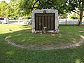
Colburn Park: A Historic Spot
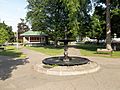
The Colburn Park Historic District is in the center of Lebanon. It includes Colburn Park and the buildings around it. Many 19th-century buildings are also part of this district. The park land was given in 1792 by Robert Colburn. It was meant for the community's meeting house, which was used as a church and town hall. Roads were built to this area, and it became a busy center in the early 1800s. A weekly farmers' market is held here from June to September. Many other community events happen throughout the year.
Famous People from Lebanon
- Nick Alexander (born 1988), 2010 and 2014 US Olympic Team ski jumper
- Aaron Baddeley (born 1981), golfer with the PGA Tour; born in Lebanon
- Minnie Willis Baines Miller (1845–1923), author
- William Wallace Smith Bliss (1815–1853), army officer and mathematician
- Duane R. Bushey (born 1944), naval officer
- Thomas C. Chalmers (1917–1995), physician, researcher
- Benjamin Champney (1817–1907), landscape painter
- Harry Morrison Cheney (1860–1937), Speaker of New Hampshire House of Representatives
- Buff Cobb (1927–2010), actress and talk-show host
- Norris Cotton (1900–1989), US senator
- Aaron H. Cragin (1821–1898), politician
- Lane Dwinell (1906–1997), manufacturer
- Experience Estabrook (1813–1894), lawyer, politician
- Jeff Friedman (born 1950), poet
- Phineas Gage (1823–1860), railroad foreman, famous for surviving a severe brain injury
- Arlie Latham (1860–1952), professional baseball player
- Jedediah Hyde Lathrop (1806–1889), merchant
- Charley Parkhurst (1812–1879), stagecoach driver
- Elisha Payne (1731–1807), businessman and politician
- George Halsey Perley (1857–1938), politician, diplomat
- Phineas Quimby (1802–1866), philosopher
- Colleen Randall (born 1952), artist
- Hezekiah Bradley Smith (1816–1887), inventor
- Joseph Smith (1805–1844), religious leader, founder of Mormonism and the Latter Day Saint movement
- George Storrs (1796–1879), writer who influenced many Christian denominations, including Seventh-day Adventists and Bible Students (later Jehovah's Witnesses)
- Sarah Strohmeyer (born 1962), author
- William Ticknor (1810–1864), publisher
- Mia Tyler (born 1978), model, actress
- Rob Woodward (born 1962), pitcher with the Boston Red Sox, radio host
- Ammi B. Young (1798–1874), architect
Images for kids
-
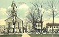
Old Town Hall in 1918
-
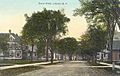
School Street c. 1910
-
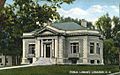
Public Library c. 1910
-
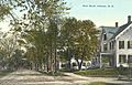
Bank Street c. 1910
-
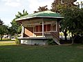
Stage in Colburn Park
-
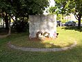
War memorial in Colburn Park
-
Another view of the War memorial
-
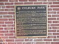
Historical plaque in Colburn Park
-
Fountain in Colburn Park


See also
 In Spanish: Lebanon (Nuevo Hampshire) para niños
