Grantham, New Hampshire facts for kids
Quick facts for kids
Grantham, New Hampshire
|
||
|---|---|---|

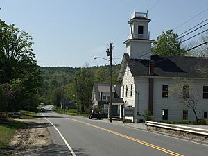
United Methodist Church in center of Grantham along Route 10, May 2010
|
||
|
||

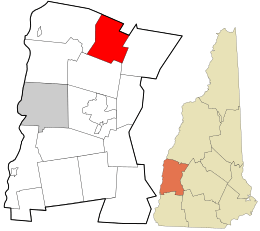
Location in Sullivan County and the state of New Hampshire
|
||
| Country | United States | |
| State | New Hampshire | |
| County | Sullivan | |
| Incorporated | 1761 | |
| Villages |
|
|
| Area | ||
| • Total | 28.05 sq mi (72.65 km2) | |
| • Land | 27.22 sq mi (70.49 km2) | |
| • Water | 0.83 sq mi (2.16 km2) 2.97% | |
| Elevation | 948 ft (289 m) | |
| Population
(2020)
|
||
| • Total | 3,404 | |
| • Density | 152/sq mi (58.6/km2) | |
| Time zone | UTC-5 (Eastern) | |
| • Summer (DST) | UTC-4 (Eastern) | |
| ZIP code |
03753
|
|
| Area code(s) | 603 | |
| FIPS code | 33-31220 | |
| GNIS feature ID | 0873610 | |
Grantham is a small town located in Sullivan County, New Hampshire, in the United States. In 2020, about 3,404 people lived there. This was more than the 2,985 people counted in 2010. A special neighborhood called Eastman is found in the eastern part of Grantham.
Contents
History of Grantham
Grantham became an official town in 1761. It was named after Thomas Robinson, 1st Baron Grantham. He was an important government official from 1754 to 1755. Before 1827, Grantham was part of a different county called Cheshire County.
Early Settlers and Families
Some of the first families to settle in Grantham were the Howes, Dunbars, and Leavitts. These families received land when the town was first created in 1761. Many hills in Grantham are still named after them today.
The Leavitt family was very large. It is said that at one point, fifty Leavitt children attended the town's school. Over the years, seventeen teachers came from the Leavitt family.
| Historical population | |||
|---|---|---|---|
| Census | Pop. | %± | |
| 1790 | 333 | — | |
| 1800 | 713 | 114.1% | |
| 1810 | 864 | 21.2% | |
| 1820 | 1,032 | 19.4% | |
| 1830 | 1,079 | 4.6% | |
| 1840 | 1,034 | −4.2% | |
| 1850 | 784 | −24.2% | |
| 1860 | 648 | −17.3% | |
| 1870 | 608 | −6.2% | |
| 1880 | 540 | −11.2% | |
| 1890 | 424 | −21.5% | |
| 1900 | 374 | −11.8% | |
| 1910 | 286 | −23.5% | |
| 1920 | 495 | 73.1% | |
| 1930 | 302 | −39.0% | |
| 1940 | 367 | 21.5% | |
| 1950 | 359 | −2.2% | |
| 1960 | 332 | −7.5% | |
| 1970 | 366 | 10.2% | |
| 1980 | 704 | 92.3% | |
| 1990 | 1,247 | 77.1% | |
| 2000 | 2,167 | 73.8% | |
| 2010 | 2,985 | 37.7% | |
| 2020 | 3,404 | 14.0% | |
| U.S. Decennial Census | |||
People of Grantham
In 2000, there were 2,167 people living in Grantham. These people lived in 924 homes, and 707 of these were families. The town had about 81 people per square mile. Most of the people living in Grantham (98.29%) were White.
Households and Families
About 24.1% of homes had children under 18 years old. Most homes (70.2%) were married couples living together. About 19.2% of homes had only one person living there. Some of these were people aged 65 or older. On average, there were 2.35 people in each home.
Age and Income
The population of Grantham had people of all ages. About 19.9% were under 18. About 21.7% were 65 or older. The average age in town was 46 years old. The average income for a home in Grantham was about $63,239. For families, the average income was around $69,271.
Geography of Grantham
Grantham covers a total area of about 72.6 square kilometers (28.0 square miles). Most of this area, about 70.5 square kilometers (27.2 square miles), is land. The rest, about 2.2 square kilometers (0.8 square miles), is water. This means water makes up almost 3% of the town.
Rivers and Ponds
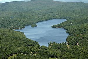
The North Branch Sugar River flows through Grantham. Smaller streams like Sawyer Brook, Stocker Brook, and Eastman Brook feed into it. Eastman Pond is a key feature of the Eastman community. Other ponds in town include Anderson Pond and Butternut Pond. All the water in Grantham eventually flows into the Connecticut River.
Mountains and Roads
The highest point in Grantham is Grantham Mountain. It stands about 811 meters (2,660 feet) above sea level. This mountain is part of the Croydon Mountain ridge, which runs along the western side of the town.
Interstate 89 goes through Grantham. It connects the town to Lebanon in the northwest and Concord in the southeast. You can get onto Interstate 89 from Exit 13 (near New Hampshire Route 10) or Exit 14. Route 10 also goes south to Newport and north to Lebanon.
Grantham is also home to the Grantham Village School, which opened in 1981. The Dunbar Free Library has been serving the community since 1903.
Neighboring Towns
- Enfield (to the north)
- Springfield (to the east)
- Croydon (to the south)
- Plainfield (to the west)
See also
 In Spanish: Grantham (Nuevo Hampshire) para niños
 | Kyle Baker |
 | Joseph Yoakum |
 | Laura Wheeler Waring |
 | Henry Ossawa Tanner |


