
Springfield, New Hampshire facts for kids
Quick facts for kids
Springfield, New Hampshire
|
|
|---|---|

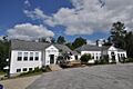
Town offices and library (2013)
|
|

Location in Sullivan County and the state of New Hampshire.
|
|
| Country | United States |
| State | New Hampshire |
| County | Sullivan |
| Incorporated | 1794 |
| Villages |
|
| Area | |
| • Total | 44.5 sq mi (115.3 km2) |
| • Land | 43.6 sq mi (113.0 km2) |
| • Water | 0.9 sq mi (2.3 km2) 1.99% |
| Elevation | 1,440 ft (438 m) |
| Population
(2020)
|
|
| • Total | 1,259 |
| • Density | 29/sq mi (11.1/km2) |
| Time zone | UTC-5 (Eastern) |
| • Summer (DST) | UTC-4 (Eastern) |
| ZIP codes | |
| Area code(s) | 603 |
| FIPS code | 33-72740 |
| GNIS feature ID | 0873723 |
Springfield is a small town located in Sullivan County, New Hampshire, in the United States. In 2020, about 1,259 people lived there. A large natural area called Gile State Forest is also found within the town's borders.
Contents
History of Springfield
Springfield was first settled by Europeans in 1769. Back then, it had a different name: "Protectworth." The town officially became "Springfield" when it was incorporated in 1794. To be incorporated means a town gets its own official government and rules. Before 1827, Springfield was part of Cheshire County.
Geography of Springfield
Springfield is in the northeast part of Sullivan County. The town covers about 115.3 square kilometers (about 44.5 square miles). Most of this area is land, with a small part (about 2.3 square kilometers) being water.
Rivers and Lakes in Springfield
Many small streams and brooks flow through Springfield. These waterways are part of larger river systems. For example, some water flows into the Sugar River, which eventually reaches the Connecticut River. Other parts of the town drain into Lake Sunapee. Water from the northeast part of town flows into the Blackwater River and then the Merrimack River. The highest point in Springfield is Melvin Hill, which is about 702 meters (2,303 feet) above sea level.
Neighboring Towns
Springfield shares its borders with several other towns:
- Grafton (to the north)
- Wilmot (to the east)
- New London (to the southeast)
- Sunapee (to the south)
- Croydon (to the southwest)
- Grantham (to the west)
- Enfield (to the northwest)
Population and People
| Historical population | |||
|---|---|---|---|
| Census | Pop. | %± | |
| 1790 | 210 | — | |
| 1800 | 570 | 171.4% | |
| 1810 | 614 | 7.7% | |
| 1820 | 967 | 57.5% | |
| 1830 | 1,202 | 24.3% | |
| 1840 | 1,252 | 4.2% | |
| 1850 | 1,270 | 1.4% | |
| 1860 | 1,021 | −19.6% | |
| 1870 | 781 | −23.5% | |
| 1880 | 732 | −6.3% | |
| 1890 | 540 | −26.2% | |
| 1900 | 439 | −18.7% | |
| 1910 | 422 | −3.9% | |
| 1920 | 349 | −17.3% | |
| 1930 | 270 | −22.6% | |
| 1940 | 364 | 34.8% | |
| 1950 | 324 | −11.0% | |
| 1960 | 283 | −12.7% | |
| 1970 | 310 | 9.5% | |
| 1980 | 532 | 71.6% | |
| 1990 | 788 | 48.1% | |
| 2000 | 945 | 19.9% | |
| 2010 | 1,311 | 38.7% | |
| 2020 | 1,259 | −4.0% | |
| U.S. Decennial Census | |||
The population of Springfield has changed a lot over the years. In 1790, only 210 people lived there. The population grew to over 1,200 by the 1830s, then slowly decreased for many years. Since the 1970s, the number of people living in Springfield has been growing again.
How People Live in Springfield
According to the 2000 census, there were 945 people living in Springfield. Most residents were White. About 30% of homes had children under 18 living there. The average age of people in Springfield was 40 years old. The average income for families was about $58,068 per year.
Internet Access
Springfield has internet services available for its residents. The main provider is Consolidated Communications. They offer modern fiber-optic connections, which are very fast. They also used to offer DSL, which is slower, but they are replacing it with fiber. In a part of Springfield called Eastman, another company called Comcast also provides internet.
Famous People from Springfield
Some notable people have connections to Springfield:
- Fairfax Downey (1893–1990), a well-known author.
- William Allen Knowlton (1920–2008), a high-ranking general in the U.S. Army.
- David Petraeus (born 1952), also a U.S. Army general and a former leader of the CIA.
- Jeriah Swetland (1817–1906), who served as a state representative in Ohio.
Images for kids
-
Springfield Town offices and library (2013)
See also
 In Spanish: Springfield (Nuevo Hampshire) para niños
