Sanbornton, New Hampshire facts for kids
Quick facts for kids
Sanbornton, New Hampshire
|
||
|---|---|---|
|
Town
|
||

|
||
|
||

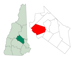
Location in Belknap County, New Hampshire
|
||
| Country | United States | |
| State | New Hampshire | |
| County | Belknap | |
| Incorporated | 1770 | |
| Villages |
|
|
| Area | ||
| • Total | 49.7 sq mi (128.6 km2) | |
| • Land | 47.4 sq mi (122.7 km2) | |
| • Water | 2.3 sq mi (5.9 km2) 4.58% | |
| Elevation | 824 ft (251 m) | |
| Population
(2020)
|
||
| • Total | 3,026 | |
| • Density | 64/sq mi (24.7/km2) | |
| Time zone | UTC-5 (Eastern) | |
| • Summer (DST) | UTC-4 (Eastern) | |
| ZIP code |
03269
|
|
| Area code(s) | 603 | |
| FIPS code | 33-67300 | |
| GNIS feature ID | 0873715 | |
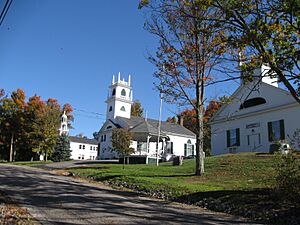
Sanbornton is a town in Belknap County, New Hampshire, United States. In 2020, about 3,026 people lived there. The town includes smaller areas called North Sanbornton and Gaza.
Contents
History of Sanbornton
Sanbornton is located where the Pemigewasset River and Winnipesaukee River meet. Because of this, it was first called "Crotchtown". In 1748, a colonial leader named Governor Benning Wentworth gave the land to his friend John Sanborn and 59 other people.
Many of these people were from nearby towns like Hampton and Exeter. Twelve of the people who received land were named Sanborn. This is why the community was later named "Sanborntown".
However, there were conflicts during the French and Indian War. This meant that people couldn't settle there permanently until 1764. The town officially became a town, or was "incorporated," by Governor John Wentworth in 1770.
A part of Sanbornton, known as Sanbornton Bridge or Bridge Village, became its own town in 1869. This area is now called Tilton.
Geography and Location
Sanbornton covers a total area of about 128.6 square kilometers (49.7 square miles). Most of this area, about 122.7 square kilometers (47.4 square miles), is land. The rest, 5.9 square kilometers (2.3 square miles), is water. Water makes up about 4.58% of the town's total area.
The Pemigewasset River forms the western border of Sanbornton. Lake Winnisquam is on its eastern side. Most of the town's water flows into Salmon Brook, which then flows into the Pemigewasset River.
The highest point in Sanbornton is the top of Hersey Mountain. It is about 610 meters (2,001 feet) above sea level. This mountain is located along the town's northwestern border.
Roads and Transportation
Several important roads pass through Sanbornton. Interstate 93 is a major highway that goes through the town. You can get to Sanbornton from I-93 at Exit 22. This highway leads north to Plymouth and south to Concord.
New Hampshire Route 132 runs alongside I-93. It connects Sanbornton to Tilton in the south and New Hampton and Ashland in the north. New Hampshire Route 127 meets NH 132 in the village of Gaza and goes southwest to Franklin.
U.S. Route 3 crosses a very small part of Sanbornton in the village of Winnisquam. Here, the road crosses over Lake Winnisquam.
Neighboring Towns
Sanbornton shares its borders with several other towns:
- Meredith (to the north)
- Laconia (to the northeast)
- Belmont (to the east)
- Tilton (to the south)
- Franklin (to the southwest)
- Hill (to the west)
- New Hampton (to the northwest)
Sanbornton Population Data
| Historical population | |||
|---|---|---|---|
| Census | Pop. | %± | |
| 1790 | 1,587 | — | |
| 1800 | 2,695 | 69.8% | |
| 1810 | 2,884 | 7.0% | |
| 1820 | 3,329 | 15.4% | |
| 1830 | 2,866 | −13.9% | |
| 1840 | 2,745 | −4.2% | |
| 1850 | 2,695 | −1.8% | |
| 1860 | 2,743 | 1.8% | |
| 1870 | 1,236 | −54.9% | |
| 1880 | 1,192 | −3.6% | |
| 1890 | 1,027 | −13.8% | |
| 1900 | 944 | −8.1% | |
| 1910 | 850 | −10.0% | |
| 1920 | 617 | −27.4% | |
| 1930 | 654 | 6.0% | |
| 1940 | 677 | 3.5% | |
| 1950 | 755 | 11.5% | |
| 1960 | 857 | 13.5% | |
| 1970 | 1,022 | 19.3% | |
| 1980 | 1,679 | 64.3% | |
| 1990 | 2,136 | 27.2% | |
| 2000 | 2,581 | 20.8% | |
| 2010 | 2,966 | 14.9% | |
| 2020 | 3,026 | 2.0% | |
| U.S. Decennial Census | |||
According to the 2000 census, there were 2,581 people living in Sanbornton. These people lived in 969 households, and 749 of these were families. The town had about 21 people per square kilometer (54.3 people per square mile).
About 33.0% of the households had children under 18 living with them. Most households (64.7%) were married couples. About 22.7% of households were not families.
The population was spread out by age. About 25.3% of the people were under 18 years old. About 10.9% were 65 years or older. The average age in the town was 40 years.
Notable People from Sanbornton
Many interesting people have connections to Sanbornton:
- Albert E. Bodwell (1851–1926), a famous architect from New Hampshire.
- Sarah A. Colby (1824–1904), a doctor.
- Joseph M. Harper (1787–1865), who was a U.S. Representative and also acted as Governor of New Hampshire.
- Don Kent (1917–2010), a meteorologist (someone who studies weather).
- Lois Lowry (born 1937), a well-known children's author, who spends her summers here.
- Daniel S. Miles (1772–1845), a religious leader.
- George W. Swain (1824–1904), a state senator in Wisconsin.
- Esther W. Taylor (1826–1904), another doctor.
See also
 In Spanish: Sanbornton (Nuevo Hampshire) para niños
 | May Edward Chinn |
 | Rebecca Cole |
 | Alexa Canady |
 | Dorothy Lavinia Brown |


