
Ashland, New Hampshire facts for kids
Quick facts for kids
Ashland, New Hampshire
|
|
|---|---|
|
Town
|
|

Main Street
|
|

Location in Grafton County, New Hampshire
|
|
| Country | United States |
| State | New Hampshire |
| County | Grafton |
| Incorporated | 1868 |
| Area | |
| • Total | 11.8 sq mi (30.5 km2) |
| • Land | 11.2 sq mi (29.1 km2) |
| • Water | 0.5 sq mi (1.4 km2) 4.63% |
| Elevation | 558 ft (170 m) |
| Population
(2020)
|
|
| • Total | 1,938 |
| • Density | 172/sq mi (66.6/km2) |
| Time zone | UTC−5 (Eastern) |
| • Summer (DST) | UTC−4 (Eastern) |
| ZIP Code |
03217
|
| Area code(s) | 603 |
| FIPS code | 33-02020 |
| GNIS feature ID | 0873534 |
Ashland is a town located in Grafton County, New Hampshire, in the United States. In 2020, about 1,938 people lived there. It is located close to the center of New Hampshire. Ashland is also home to the Scribner-Fellows State Forest.
The main part of the town, where most people live, is called the Ashland census-designated place (CDP). This area is found where U.S. Route 3 and New Hampshire Route 25 meet NH Route 132.
Contents
History of Ashland
Ashland was once part of a larger area called Holderness. This land was officially granted in 1751 by Governor Benning Wentworth. However, a war called the French and Indian War made it unsafe to settle there for a while.
In 1761, the land was granted again as "New Holderness." The word "New" was dropped in 1816. People started settling in the area in 1763. Most of the town was used for farming. But Holderness Village, located on the Squam River, was different. The river had waterfalls that provided strong water power. This power was perfect for running mills.
Around 1770-1771, a sawmill (for cutting wood) and a gristmill (for grinding grain) were built. Later, in 1840, the Squam Lake Woolen Mill opened. Factories in Ashland made many things, including hosiery (socks and stockings), gloves, sports gear, wood items, and paper.
In 1849, the Boston, Concord & Montreal Railroad came to town. This railroad brought goods and also tourists. Tourists would travel by steamer up the Squam River to visit hotels on the Squam Lakes.
Over time, the busy factory area of Holderness Village became very different from the farming parts of Holderness. So, in 1868, Holderness Village became its own town called Ashland. It was named after "Ashland," the famous estate of Henry Clay in Kentucky. The last big textile mill in Ashland closed in 2002. Today, Ashland is a place where people live and enjoy vacations.
-
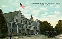
Downtown c. 1912
-
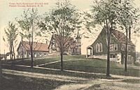
View of Town Hall c. 1910
-
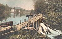
Mill dam c. 1910
-
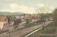
View of the mills c. 1908


Geography of Ashland
Ashland covers a total area of about 30.5 square kilometers (about 11.8 square miles). Most of this is land (29.1 sq km), and a smaller part is water (1.4 sq km). Water makes up about 4.63% of the town's total area.
The Pemigewasset River forms the western border of Ashland. The town also has the Squam River and Owl Brook flowing through it. Little Squam Lake is located on the eastern side of Ashland.
The highest point in Ashland is Hicks Hill, which stands about 422 meters (1,386 feet) above sea level. Ashland is part of the Merrimack River watershed. This means that all the rain and melted snow in Ashland eventually flows into the Merrimack River.
Major roads that serve the town include Interstate 93, U.S. Route 3, and state routes 25, 132, and 175.
Population Changes in Ashland
| Historical population | |||
|---|---|---|---|
| Census | Pop. | %± | |
| 1870 | 885 | — | |
| 1880 | 960 | 8.5% | |
| 1890 | 1,193 | 24.3% | |
| 1900 | 1,289 | 8.0% | |
| 1910 | 1,412 | 9.5% | |
| 1920 | 1,325 | −6.2% | |
| 1930 | 1,375 | 3.8% | |
| 1940 | 1,460 | 6.2% | |
| 1950 | 1,599 | 9.5% | |
| 1960 | 1,473 | −7.9% | |
| 1970 | 1,599 | 8.6% | |
| 1980 | 1,807 | 13.0% | |
| 1990 | 1,915 | 6.0% | |
| 2000 | 1,955 | 2.1% | |
| 2010 | 2,076 | 6.2% | |
| 2020 | 1,938 | −6.6% | |
| U.S. Decennial Census | |||
According to the census taken in 2010, there were 2,076 people living in Ashland. There were 980 households, which are groups of people living together. About 22.4% of these households had children under 18 years old. Many homes were occupied by married couples.
The average age of people in Ashland in 2010 was about 43.1 years old.
Places to Visit in Ashland
- Ashland Railroad Station (built around 1869, rebuilt 1891)
- Pauline E. Glidden Toy Museum (from about 1810)
- Whipple House Museum (built 1837)
- St. Mark's Episcopal Church (built 1899)
Famous People from Ashland
- James Frankland Briggs (1827–1905), a US congressman.
- Moses Cheney (1793–1875), who worked to end slavery and was part of the Underground Railroad.
- Oren B. Cheney (1816–1903), who founded Bates College.
- Person C. Cheney (1828–1901), a US senator and the 43rd governor of New Hampshire.
- George Hoyt Whipple (1878–1976), a scientist who won a Nobel Prize.
See also
 In Spanish: Ashland (Nuevo Hampshire) para niños
