Ashland (CDP), New Hampshire facts for kids
Quick facts for kids
Ashland, New Hampshire
|
|
|---|---|

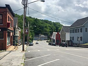
Main Street in Ashland. Civil War monument in distance.
|
|
| Country | United States |
| State | New Hampshire |
| County | Grafton |
| Town | Ashland |
| Area | |
| • Total | 1.37 sq mi (3.54 km2) |
| • Land | 1.33 sq mi (3.45 km2) |
| • Water | 0.03 sq mi (0.09 km2) |
| Elevation | 560 ft (170 m) |
| Population
(2020)
|
|
| • Total | 1,082 |
| • Density | 812.31/sq mi (313.64/km2) |
| Time zone | UTC-5 (Eastern (EST)) |
| • Summer (DST) | UTC-4 (EDT) |
| ZIP code |
03217
|
| Area code(s) | 603 |
| FIPS code | 33-01940 |
| GNIS feature ID | 2629711 |
Ashland is a small village in New Hampshire, United States. It's known as a census-designated place (CDP). This means it's a special area that the government counts for population, even though it's part of a larger town. Ashland is located in Grafton County. In 2020, about 1,082 people lived in the Ashland CDP. The whole town of Ashland had a population of 1,938 people.
Where is Ashland?
Ashland CDP is in the southwest part of the town of Ashland. It sits on both sides of the Squam River. This river drops about 50 feet as it flows through the middle of the village.
To the south, Ashland CDP borders the town of New Hampton. To the west, you'll find Interstate 93, a major highway. The northern edge of the CDP is near where River Street meets U.S. Route 3. This spot is just south of a dam on the Squam River. This dam helps control the water levels of Little Squam Lake and Squam Lake. The eastern side of the CDP is east of Thompson Street and Ledgewood Lane.
Roads and Travel
Several important roads run through Ashland. U.S. Route 3 and New Hampshire Route 25 go right through the center of the village.
- If you head northeast on US 3 (southbound) and NH 25 (eastbound), you'll reach Holderness in about 4 miles.
- If you go northwest on US 3 (northbound) and NH 25 (westbound), you'll get to Plymouth in about 6 miles.
Interstate 93 crosses Routes 3 and 25 on the west side of Ashland at Exit 24.
Another road, New Hampshire Route 132, starts from Routes 3 and 25 in central Ashland. It goes south about 7 miles to New Hampton.
Land and Water
The Ashland CDP covers a total area of about 3.5 square kilometers (1.37 square miles). Most of this area, about 3.4 square kilometers (1.33 square miles), is land. The rest, about 0.1 square kilometers (0.03 square miles), is water. This means about 2.59% of the CDP's area is water.
Who Lives Here?
| Historical population | |||
|---|---|---|---|
| Census | Pop. | %± | |
| 1950 | 1,215 | — | |
| 1960 | 1,237 | 1.8% | |
| 1970 | 1,391 | 12.4% | |
| 1980 | 1,479 | 6.3% | |
| 2010 | 1,244 | — | |
| 2020 | 1,082 | −13.0% | |
| U.S. Decennial Census | |||
In 2010, there were 1,244 people living in the Ashland CDP. These people lived in 599 homes. About half of these homes were families. The average age of people in Ashland was around 42.8 years old.
The estimated yearly income for a household in Ashland was about $40,000 between 2011 and 2015. For families, the median income was around $52,452. A small number of people and families lived below the poverty line during this time.
See also
 In Spanish: Ashland (condado de Grafton) para niños
 | Sharif Bey |
 | Hale Woodruff |
 | Richmond Barthé |
 | Purvis Young |


