Plymouth (CDP), New Hampshire facts for kids
Quick facts for kids
Plymouth, New Hampshire
|
|
|---|---|

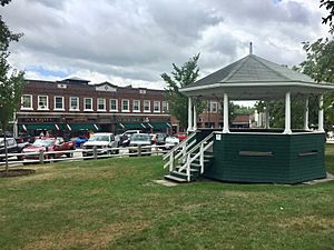
View of Plymouth from the Town Oval, 2018
|
|
| Country | United States |
| State | New Hampshire |
| County | Grafton |
| Town | Plymouth |
| Area | |
| • Total | 5.95 sq mi (15.41 km2) |
| • Land | 5.88 sq mi (15.22 km2) |
| • Water | 0.07 sq mi (0.19 km2) |
| Elevation | 515 ft (157 m) |
| Population
(2020)
|
|
| • Total | 4,730 |
| • Density | 805.11/sq mi (310.87/km2) |
| Time zone | UTC-5 (Eastern (EST)) |
| • Summer (DST) | UTC-4 (EDT) |
| ZIP code |
03264
|
| Area code(s) | 603 |
| FIPS code | 33-62580 |
| GNIS feature ID | 2378089 |
Plymouth is a special kind of community called a census-designated place (CDP). It's the main village in the larger town of Plymouth in Grafton County, New Hampshire, USA. In 2020, about 4,730 people lived here. The famous Plymouth State University campus is also located in Plymouth.
Contents
Exploring Plymouth's Location
Plymouth CDP is found in the eastern part of the town of Plymouth. It sits on the west side of the Pemigewasset River. This area includes the town center, the Plymouth State University campus, and homes nearby.
Rivers and Roads Around Plymouth
The eastern edge of Plymouth is defined by the Pemigewasset River. Other natural boundaries include Glove Hollow Brook to the south and Clay Brook to the west. To the north, you'll find Route 25 and the Baker River.
Major roads are also close by. Interstate 93 runs just east of Plymouth. You can get to it from Exit 25 or Exit 26. I-93 goes north about 44 miles to Littleton. It also goes south about 43 miles to Concord, which is the state capital.
U.S. Route 3 goes right through the middle of Plymouth. It leads north about 7 miles to Campton. South of Plymouth, it goes about 6 miles to Ashland.
How Big is Plymouth?
The Plymouth CDP covers a total area of about 5.95 square miles (15.4 square kilometers). Most of this area, about 5.88 square miles (15.2 square kilometers), is land. A small part, about 0.07 square miles (0.2 square kilometers), is water.
People Living in Plymouth
| Historical population | |||
|---|---|---|---|
| Census | Pop. | %± | |
| 1950 | 2,107 | — | |
| 1960 | 2,244 | 6.5% | |
| 1970 | 3,109 | 38.5% | |
| 1980 | 3,628 | 16.7% | |
| 1990 | 3,967 | 9.3% | |
| 2000 | 3,528 | −11.1% | |
| 2010 | 4,456 | 26.3% | |
| 2020 | 4,730 | 6.1% | |
| U.S. Decennial Census | |||
The number of people living in Plymouth is greatly affected by Plymouth State University. Many students live in dorms and other housing in the community.
Population Changes Over Time
The population of Plymouth has changed quite a bit over the years. In 1950, there were 2,107 people. By 2020, the population had grown to 4,730. This shows how the community has developed and grown.
Who Lives Here?
In 2010, there were 4,456 people living in Plymouth. Most residents, about 96.4%, were white. Other groups included African American, Native American, and Asian people. About 1.8% of the population was of Hispanic or Latino background.
The average age in Plymouth in 2010 was about 20.8 years old. This is quite young, mainly because of the many college students living there.
See also
 In Spanish: Plymouth (condado de Grafton) para niños
 | Janet Taylor Pickett |
 | Synthia Saint James |
 | Howardena Pindell |
 | Faith Ringgold |


