Northfield, New Hampshire facts for kids
Quick facts for kids
Northfield, New Hampshire
|
||
|---|---|---|

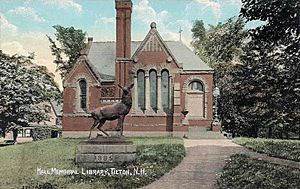
Hall Memorial Library c. 1905
|
||
|
||
| Motto(s):
"A Great Place to Live!"
|
||

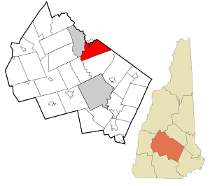
Location in Merrimack County and the state of New Hampshire
|
||
| Country | United States | |
| State | New Hampshire | |
| County | Merrimack | |
| Incorporated | 1780 | |
| Area | ||
| • Total | 28.9 sq mi (74.8 km2) | |
| • Land | 28.5 sq mi (73.8 km2) | |
| • Water | 0.4 sq mi (1.0 km2) 1.27% | |
| Elevation | 440 ft (130 m) | |
| Population
(2020)
|
||
| • Total | 4,872 | |
| • Density | 171/sq mi (66.0/km2) | |
| Time zone | UTC-5 (Eastern) | |
| • Summer (DST) | UTC-4 (Eastern) | |
| ZIP code |
03276
|
|
| Area code(s) | 603 | |
| FIPS code | 33-54260 | |
| GNIS feature ID | 0873686 | |
Northfield is a town located in Merrimack County, New Hampshire, in the United States. In 2020, about 4,872 people lived there. It's known as a "New England town," which is a special type of local government.
Contents
Discovering Northfield's Past
European settlers first came to the area that is now Northfield in the early 1700s. At first, Northfield was part of a larger town called Canterbury, which was created in 1741.
Early Settlement and Protection
Back then, it was a "frontier town." This means it was on the edge of settled areas. To protect the settlers, a special fort called a "garrison fort" was built on a hill near Canterbury Center. Captain Jeremiah Clough was in charge of this fort. People believe that the first settlers of Northfield were scouts from this fort. They patrolled the northern areas in the 1740s.
Growth and Industry in Northfield
The northern parts of Canterbury, which became Northfield, grew quickly. Farming was the main way people made a living. Also, dams were built along the Winnipesaukee and Merrimack rivers. These dams used water power to run early sawmills (for cutting wood) and gristmills (for grinding grain). By the 1770s, many people lived in this northern area.
Becoming Its Own Town
By 1780, it was hard for people in the northern fields to travel to Canterbury's center for town meetings. So, on March 30, 1780, they asked the State of New Hampshire to become their own town. They explained that they lived "a great Distance" from Canterbury's center. They wanted to be their own "body Politick and Corporate" called Northfield.
Forty-three residents signed this request. The state legislature approved it, and the Town of Northfield was officially created! Later, in 1828, there was a small change to the county borders that affected Northfield and Tilton.
Railroads and Mills Shape the Town
In 1848, the Boston, Concord and Montreal Railroad came to Northfield. This helped the town grow alongside Tilton, which is just across the river. They became a "mill town" together. The Winnipesaukee River provided water power for many mills. By 1859, Northfield had a population of 1,332 people. It was home to a factory that made wool and another that made wrapping paper.
Northfield kept a strong mix of factories and farms through the 1800s and most of the 1900s. Over time, large textile (cloth) and paper mills closed down. Some old mill buildings were taken down. Others were used to make new things, like optical lenses or lead batteries.
Exploring Northfield's Landscape

Northfield covers about 74.8 square kilometers (28.9 square miles). Most of this area, about 73.8 square kilometers (28.5 square miles), is land. The rest, about 1.0 square kilometer (0.4 square miles), is water. Water makes up about 1.27% of the town.
Rivers, Hills, and Ponds
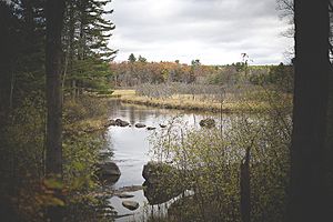
The town's water flows into the Merrimack River. This happens mainly through the Winnipesaukee River and a smaller stream called Williams Brook. The Winnipesaukee River forms the northern edge of Northfield. It separates Northfield from the town of Tilton.
Northfield has gentle, rolling hills. The highest point is the top of Bean Hill. It is about 457 meters (1,500 feet) above sea level, near the town's southern border. Two important bodies of water in Northfield are Sandogardy Pond and Knowles Pond. Sandogardy Pond is in the southwest, and Knowles Pond is on the east side.
Northfield and Tilton Villages
The main village of Northfield is in the northern part of the town. It sits on the south bank of the Winnipesaukee River. Right across the river is the village of Tilton. Together, these two villages form what is called the "Tilton Northfield census-designated place."
Neighboring Towns
Northfield shares its borders with several other towns:
- Tilton (to the north)
- Belmont (to the northeast)
- Gilmanton (to the east)
- Canterbury (to the south)
- Boscawen (to the southwest)
- Franklin (to the west)
Northfield's Economy and Jobs
Today, Northfield is home to over 70 businesses, both big and small. It's very close to Tilton, which has a lot of shops and businesses. Because of this, Northfield hasn't developed a huge shopping area of its own. However, other types of businesses have given Northfield a strong and varied economy.
Manufacturing and Services
Many companies that make things are in Northfield. These include Eptam Plastics, Blouin Steel Fabricators, Freudenberg NOK, and PCC Structurals. These companies are a big part of the town's "manufacturing/industrial base." This means they make products.
The "service sector" is also very important. This sector includes jobs that provide services, not products. More than 400 people work in service jobs in Northfield. This makes up 40% of all jobs in the town.
Local and Commuter Jobs
Many people who live in Northfield travel to nearby towns for work. They might go to Tilton, Concord, or Manchester. But nearly a thousand people also work right in Northfield.
Fun Activities
Highland Mountain Bike Park is a popular spot in the southern part of Northfield. It's a great place for mountain biking!
Getting Around Northfield
Northfield is located in the middle of New Hampshire. Several important roads and highways pass through or near it.
Major Highways
Interstate 93 runs through Northfield. It has one partial exit in town (Exit 19). This exit lets you get on the highway going south and get off if you're coming from the north. A full exit (Exit 20) is less than a mile north of Northfield, in Tilton.
Local Roads
New Hampshire Route 132 also crosses Northfield. It runs north and south, parallel to Interstate 93, and helps people get around locally. New Hampshire Route 140 goes east and west. It crosses the northern tip of town, connecting Tilton with Belmont, Gilmanton, and Alton.
The combined U.S. Route 3 and NH Route 11 run east and west through Tilton. This is just north of Northfield's town line.
Airports and City Distances
The closest major airport is Manchester-Boston Regional Airport. It is about 40 miles (64 km) south of Northfield.
Here are some distances to other cities:
- Concord – 17 miles (27 km)
- Manchester – 34 miles (55 km)
- Boston, Massachusetts – 85 miles (137 km)
- New York, New York – 290 miles (467 km)
- Montreal, Quebec, Canada – 236 miles (380 km)
Learning in Northfield
Northfield is part of the Winnisquam Regional School District. This district helps provide education for students in the area.
Schools in Northfield
Younger students attend Union Sanborn School and Southwick School. Both of these elementary schools are located right in Northfield.
Schools in Nearby Tilton
Older students go to Winnisquam Regional Middle School and Winnisquam Regional High School. These schools are in the nearby town of Tilton.
Special Education and Prep Schools
Northfield and Tilton are also home to the Tilton School. This is an independent "college-preparatory" school. This means it helps students in grades 9-12 get ready for college.
Northfield also has the Spaulding Youth Center. This center offers special programs for children and young people. These programs help kids with learning challenges, emotional needs, or those who have experienced difficult situations.
Northfield's Population Over Time
| Historical population | |||
|---|---|---|---|
| Census | Pop. | %± | |
| 1790 | 606 | — | |
| 1800 | 925 | 52.6% | |
| 1810 | 1,057 | 14.3% | |
| 1820 | 1,304 | 23.4% | |
| 1830 | 1,169 | −10.4% | |
| 1840 | 1,413 | 20.9% | |
| 1850 | 1,332 | −5.7% | |
| 1860 | 1,051 | −21.1% | |
| 1870 | 833 | −20.7% | |
| 1880 | 918 | 10.2% | |
| 1890 | 1,115 | 21.5% | |
| 1900 | 1,227 | 10.0% | |
| 1910 | 1,474 | 20.1% | |
| 1920 | 1,522 | 3.3% | |
| 1930 | 1,336 | −12.2% | |
| 1940 | 1,543 | 15.5% | |
| 1950 | 1,561 | 1.2% | |
| 1960 | 1,784 | 14.3% | |
| 1970 | 2,193 | 22.9% | |
| 1980 | 3,051 | 39.1% | |
| 1990 | 4,263 | 39.7% | |
| 2000 | 4,548 | 6.7% | |
| 2010 | 4,829 | 6.2% | |
| 2020 | 4,872 | 0.9% | |
| U.S. Decennial Census | |||

In 2010, there were 4,829 people living in Northfield. These people lived in 1,843 households, with 1,309 of them being families. Most of the people living in Northfield were white (96.6%).
About 24.6% of the population was under 18 years old. The average age in Northfield was about 39.2 years. For every 100 females, there were about 97.7 males.
Between 2011 and 2015, the average yearly income for a household was about $65,536. For families, it was about $72,138. About 6.7% of the people and 5.4% of the families in Northfield lived below the poverty line.
Famous People from Northfield
- Joseph Libbey Folsom (1817–1855): He was an officer in the US Army and invested in real estate. He is known for founding the city that is now Folsom, California.
- Richard S. Molony (1811–1891): He served as a US congressman.
- Robert Smith (1802–1867): He also served as a US congressman.
See also
 In Spanish: Northfield (Nuevo Hampshire) para niños


