
Canterbury, New Hampshire facts for kids
Quick facts for kids
Canterbury, New Hampshire
|
||
|---|---|---|

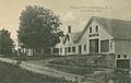
Town center: Canterbury United Community Church (L) & Country Store (R)
|
||
|
||

Location in Merrimack County and the state of New Hampshire
|
||
| Country | United States | |
| State | New Hampshire | |
| County | Merrimack | |
| Incorporated | 1741 | |
| Villages |
|
|
| Area | ||
| • Total | 44.71 sq mi (115.79 km2) | |
| • Land | 43.88 sq mi (113.64 km2) | |
| • Water | 0.83 sq mi (2.15 km2) 1.86% | |
| Elevation | 599 ft (183 m) | |
| Population
(2020)
|
||
| • Total | 2,389 | |
| • Density | 54/sq mi (21.0/km2) | |
| Time zone | UTC-5 (Eastern) | |
| • Summer (DST) | UTC-4 (Eastern) | |
| ZIP code |
03224
|
|
| Area code(s) | 603 | |
| FIPS code | 33-09860 | |
| GNIS feature ID | 0873559 | |

Canterbury is a small town located in Merrimack County, New Hampshire, in the United States. In 2020, about 2,389 people lived here. A famous place called the Canterbury Shaker Village is found in the eastern part of the town.
Contents
Exploring Canterbury's Past
Canterbury was first given land by Lieutenant Governor John Wentworth in 1727. The town was named after William Wake, who was the Archbishop of Canterbury.
Originally, Canterbury was a timber fort and a place for trading. Captain Jeremiah Clough ran this trading post on a hill near Canterbury Center. The Pennacook people would come here to trade. Canterbury officially became a town in 1741. There were several fortified houses, called garrison houses or stockades, in the area until at least 1758.
Canterbury's Location and Landscape
Canterbury covers a total area of about 115.8 square kilometers (44.7 square miles). Most of this area, about 113.6 square kilometers (43.9 square miles), is land. The rest, about 2.1 square kilometers (0.8 square miles), is water. This means water makes up about 1.86% of the town.
The highest point in Canterbury is a hill near Forest Pond, close to the town's northern border. This spot is about 424 meters (1,390 feet) above sea level. The Merrimack River forms the western border of Canterbury. The Soucook River drains the eastern part of the town. All of Canterbury's water flows into the Merrimack River watershed.
Neighboring Towns
Canterbury shares its borders with these towns:
- Northfield (to the north)
- Gilmanton (to the northeast)
- Loudon (to the east)
- Concord (to the south)
- Boscawen (to the west)
Population Over Time
Canterbury's population has changed quite a bit over the years. Here's a look at how many people have lived in the town during different census years:
| Historical population | |||
|---|---|---|---|
| Census | Pop. | %± | |
| 1790 | 1,038 | — | |
| 1800 | 1,114 | 7.3% | |
| 1810 | 1,526 | 37.0% | |
| 1820 | 1,696 | 11.1% | |
| 1830 | 1,663 | −1.9% | |
| 1840 | 1,643 | −1.2% | |
| 1850 | 1,614 | −1.8% | |
| 1860 | 1,522 | −5.7% | |
| 1870 | 1,169 | −23.2% | |
| 1880 | 1,033 | −11.6% | |
| 1890 | 964 | −6.7% | |
| 1900 | 821 | −14.8% | |
| 1910 | 680 | −17.2% | |
| 1920 | 655 | −3.7% | |
| 1930 | 505 | −22.9% | |
| 1940 | 659 | 30.5% | |
| 1950 | 627 | −4.9% | |
| 1960 | 674 | 7.5% | |
| 1970 | 895 | 32.8% | |
| 1980 | 1,410 | 57.5% | |
| 1990 | 1,687 | 19.6% | |
| 2000 | 1,979 | 17.3% | |
| 2010 | 2,352 | 18.8% | |
| 2020 | 2,389 | 1.6% | |
| U.S. Decennial Census | |||
In 2000, there were 1,979 people living in Canterbury. About 33.9% of the households had children under 18. The average household had 2.64 people. The median age in town was 42 years old. About 24.5% of the population was under 18 years old.
Fun Events and Attractions
Yearly Celebrations
Canterbury hosts a fun event called the Canterbury Fair every year on the last Saturday in July. This fair features local artists, live music, and even a 5K run.
The town also celebrates the Fourth of July with a parade and a fireworks show put on by the local fire department.
Places to Visit
The most popular attraction in Canterbury is the Canterbury Shaker Village. This village was started in 1792. At its busiest time in the 1850s, over 300 people lived and worked there. They had about 100 buildings spread across 4,000 acres (16 square kilometers).
The Shakers made a living by farming and selling seeds, herbs, and medicines. They also made textiles, pails, and brooms. The last Shaker resident, Sister Ethel Hudson, passed away in 1992. The village is now a museum, opened in 1969, to teach people about the Shakers' unique way of life.
Canterbury Shaker Village is a famous historic site. It has 25 original Shaker buildings and four rebuilt ones. It also includes 694 acres (2.8 square kilometers) of forests, fields, and gardens that are protected. It is recognized as a National Historic Landmark because of its well-preserved buildings and history.
Canterbury also has an active historical society. They host events throughout the year and maintain the Elizabeth Houser Museum. This museum is in the old Center Schoolhouse, which was once a one-room school. It also has an archive of materials about Canterbury dating back to the early 1700s.
Parks and Outdoor Fun
Canterbury is home to two state forests: Ayers State Forest and Shaker State Forest. Ayers State Forest covers about 50 acres (0.2 square kilometers). Shaker State Forest is larger, covering about 226.5 acres (0.9 square kilometers). These forests offer great opportunities for outdoor activities.
Famous People from Canterbury
Here are some notable people who have connections to Canterbury:
- Abiel Foster (1735–1806), a US congressman
- Stephen Symonds Foster (1809–1881), a strong supporter of ending slavery
- Joseph M. Harper (1787–1865), a US congressman and Acting Governor of New Hampshire
- Kenneth MacKenna (1899–1962), an actor and film director
- Colby James West (born 1985), a freestyle skier
Images for kids
-
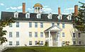
Shakers' dwelling c. 1920
-
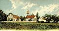
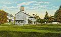
Canterbury Shaker Village c. 1906
-
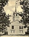
Worsted Church c. 1906
-
Shakers' office c. 1905
-
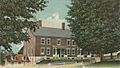
Pleasant View Inn c. 1910
-
Shaker Village c. 1920


See also
 In Spanish: Canterbury (Nuevo Hampshire) para niños
