Webster, New Hampshire facts for kids
Quick facts for kids
Webster, New Hampshire
|
|
|---|---|

|
|

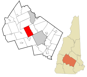
Location in Merrimack County and the state of New Hampshire.
|
|
| Country | United States |
| State | New Hampshire |
| County | Merrimack |
| Incorporated | 1860 |
| Villages | Webster Swetts Mills |
| Area | |
| • Total | 28.8 sq mi (74.6 km2) |
| • Land | 28.2 sq mi (73.1 km2) |
| • Water | 0.6 sq mi (1.5 km2) 2.02% |
| Elevation | 682 ft (208 m) |
| Population
(2020)
|
|
| • Total | 1,913 |
| • Density | 68/sq mi (26.2/km2) |
| Time zone | UTC-5 (Eastern) |
| • Summer (DST) | UTC-4 (Eastern) |
| ZIP code |
03303
|
| Area code(s) | 603 |
| FIPS code | 33-80020 |
| GNIS feature ID | 0873750 |
Webster is a small town in Merrimack County, New Hampshire, USA. In 2020, about 1,913 people lived there.
Town History
Webster used to be part of a town called Boscawen. It became its own town in 1860. The town is named after Daniel Webster, a very important American leader and speaker.
Geography of Webster
Webster covers a total area of about 28.8 square miles (74.6 km2). Most of this area, about 28.2 square miles (73.1 km2), is land. The rest, about 0.58 square miles (1.5 km2), is water.
The Blackwater River flows through Webster from north to south. This river eventually joins the Contoocook River. All the water in Webster flows into the larger Merrimack River.
The highest point in Webster is a hill about 870 feet (270 m) above sea level. This spot is near the middle of town and offers a view of Lake Winnepocket.
Neighboring Towns
Webster shares its borders with these towns:
- Salisbury (to the north)
- Boscawen (to the east)
- Concord (to the southeast)
- Hopkinton (to the south)
- Warner (to the west)
Population Information
| Historical population | |||
|---|---|---|---|
| Census | Pop. | %± | |
| 1870 | 689 | — | |
| 1880 | 647 | −6.1% | |
| 1890 | 564 | −12.8% | |
| 1900 | 496 | −12.1% | |
| 1910 | 445 | −10.3% | |
| 1920 | 334 | −24.9% | |
| 1930 | 360 | 7.8% | |
| 1940 | 351 | −2.5% | |
| 1950 | 386 | 10.0% | |
| 1960 | 457 | 18.4% | |
| 1970 | 680 | 48.8% | |
| 1980 | 1,095 | 61.0% | |
| 1990 | 1,405 | 28.3% | |
| 2000 | 1,579 | 12.4% | |
| 2010 | 1,872 | 18.6% | |
| 2020 | 1,913 | 2.2% | |
| U.S. Decennial Census | |||
In 2000, there were 1,579 people living in Webster. There were 581 households, which are groups of people living together. Most of the people living in Webster were White.
About 35% of the households had children under 18 living with them. Most households were married couples. The average age of people in Webster was 39 years old.
See also

- In Spanish: Webster (Nuevo Hampshire) para niños
 | Delilah Pierce |
 | Gordon Parks |
 | Augusta Savage |
 | Charles Ethan Porter |

