
Bradford, New Hampshire facts for kids
Quick facts for kids
Bradford, New Hampshire
|
||
|---|---|---|

Bradford Town Hall
|
||
|
||

Location in Merrimack County and the state of New Hampshire.
|
||
| Country | United States | |
| State | New Hampshire | |
| County | Merrimack | |
| Incorporated | 1787 | |
| Villages |
|
|
| Area | ||
| • Total | 35.9 sq mi (93.1 km2) | |
| • Land | 35.3 sq mi (91.3 km2) | |
| • Water | 0.7 sq mi (1.8 km2) 1.92% | |
| Elevation | 686 ft (209 m) | |
| Population
(2020)
|
||
| • Total | 1,662 | |
| • Density | 47/sq mi (18.2/km2) | |
| Time zone | UTC-5 (Eastern) | |
| • Summer (DST) | UTC-4 (Eastern) | |
| ZIP code |
03221
|
|
| Area code(s) | 603 | |
| FIPS code | 33-06980 | |
| GNIS feature ID | 0873549 | |

Bradford is a small town in Merrimack County, New Hampshire, USA. It is a classic New England town. In 2020, about 1,662 people lived here. The main part of town, called Bradford village, is where routes 103 and 114 meet. There is also a smaller area called Bradford Center.
Contents
History of Bradford

Bradford was first given to John Pierce and George Jaffrey in 1765 by Governor Benning Wentworth. The first settlers, Deacon William Presbury and his family, arrived in 1771. Three years later, more families came. Many of them were from a town called Bradford, Massachusetts. Because of this, the new settlement was first named "New Bradford."
Later, it was called "Bradfordton." But on September 27, 1787, the state government officially made it a town. They gave it the name Bradford.
Early Industries and Growth
Some parts of Bradford are hilly, but much of the town is in a valley. This valley has different types of soil. Streams in the area were important. They provided water power for early factories and mills.
By 1859, Bradford had grown to 1,341 people. The town had several businesses. These included a factory that made woolen cloth. There was also a place that made sashes, blinds, and doors. Other businesses included a wheelwright shop (for making wheels), two sawmills, and a gristmill (for grinding grain). There was also a tannery (for making leather) and a clothing mill.
In 1850, the Concord & Claremont Railroad reached Bradford. This train line connected Bradford to Concord. Bradford was the end of the line until 1871. Then, the railroad was extended to Claremont.
Geography of Bradford
Bradford covers about 93.1 square kilometers (35.9 square miles). Most of this area, about 91.3 square kilometers (35.3 square miles), is land. The rest, about 1.8 square kilometers (0.7 square miles), is water.
The main village of Bradford is in the northern part of town. It is where routes 103 and 114 cross. This area is just north of the Warner River. It is also next to the outlet of Todd Lake.
Lakes and Rivers
The biggest lake in Bradford is Lake Massasecum. It is located near the eastern edge of the town. The Warner River and its smaller streams flow through the northern and central parts of Bradford. The southern part of town has streams that flow into the Contoocook River. All of Bradford is part of the larger Merrimack River watershed. This means all the water eventually flows into the Merrimack River.
Highest Points
The highest spot in Bradford is an unnamed hill. It is about 639 meters (2,096 feet) tall. This hill overlooks Ayers Pond on the western border of the town. Other high points include Knights Hill, which is about 582 meters (1,910 feet) tall. Rowes Hill is another high point, reaching about 594 meters (1,950 feet). These hills make up a large, hilly area in the southern part of Bradford.
Population and People
| Historical population | |||
|---|---|---|---|
| Census | Pop. | %± | |
| 1790 | 217 | — | |
| 1800 | 740 | 241.0% | |
| 1810 | 1,034 | 39.7% | |
| 1820 | 1,318 | 27.5% | |
| 1830 | 1,285 | −2.5% | |
| 1840 | 1,331 | 3.6% | |
| 1850 | 1,341 | 0.8% | |
| 1860 | 1,180 | −12.0% | |
| 1870 | 1,081 | −8.4% | |
| 1880 | 950 | −12.1% | |
| 1890 | 810 | −14.7% | |
| 1900 | 805 | −0.6% | |
| 1910 | 695 | −13.7% | |
| 1920 | 580 | −16.5% | |
| 1930 | 587 | 1.2% | |
| 1940 | 661 | 12.6% | |
| 1950 | 606 | −8.3% | |
| 1960 | 508 | −16.2% | |
| 1970 | 679 | 33.7% | |
| 1980 | 1,115 | 64.2% | |
| 1990 | 1,405 | 26.0% | |
| 2000 | 1,454 | 3.5% | |
| 2010 | 1,650 | 13.5% | |
| 2020 | 1,662 | 0.7% | |
| U.S. Decennial Census | |||
In 2010, there were 1,650 people living in Bradford. They lived in 667 households. A household is a group of people living together. There were also 471 families. The town had 917 housing units. About 250 of these were empty. Many of the empty homes were used for vacations or holidays.
Most of the people in Bradford (97.5%) were white. A small number were from other backgrounds. About 1.3% of the population was Hispanic or Latino.
Families and Age Groups
In 2010, about 29.1% of households had children under 18. Most households (57.7%) were married couples living together. About 29.4% of households were not families. This means they were individuals or groups of unrelated people.
The average household had 2.47 people. The average family had 2.86 people.
Looking at age groups, 20.7% of the population was under 18. About 13.2% of people were 65 or older. The average age in Bradford was 46.3 years old. For every 100 females, there were about 100.7 males.
Places to Visit in Bradford
Bradford has several interesting places to see:
- Bement Covered Bridge: This historic bridge was built in 1854.
- Bradford Bog: A natural wetland area.
- Bradford Center Meetinghouse: An old meeting house in Bradford Center.
- Bradford Pines State Forest: A protected forest area.
- Bradford Town Hall: The town's government building.
- Lake Massasecum: A large lake popular for recreation.
- Lake Todd: Another lake in the area.
- Warner River: A river that flows through the town.
- West Branch Warner River: A branch of the Warner River.
Notable People from Bradford
Some interesting people have connections to Bradford:
- Odds Bodkin (born 1953): A famous storyteller and musician.
- John Q. A. Brackett (1842–1918): He was the 36th governor of Massachusetts.
- John Milton Hawks (1826–1910): An abolitionist and doctor. Abolitionists worked to end slavery.
- Thorkild Jacobsen (1904–1993): A Danish-American historian.
- Mason Tappan (1817–1886): He served as a United States congressman. He was also New Hampshire's Attorney General.
- Bainbridge Wadleigh (1831–1891): He was a United States senator.
Images for kids
-
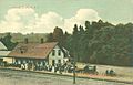
Concord & Claremont Railroad depot in 1906
-
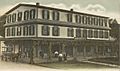
The Bradford Hotel in 1906
-
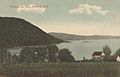
Lake Massasecum in 1909


See also
 In Spanish: Bradford (Nuevo Hampshire) para niños
