North Hampton, New Hampshire facts for kids
Quick facts for kids
North Hampton, New Hampshire
|
||
|---|---|---|

|
||
|
||

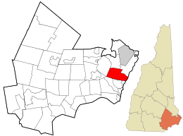
Location in Rockingham County and the state of New Hampshire.
|
||
| Country | United States | |
| State | New Hampshire | |
| County | Rockingham | |
| Incorporated | November 30, 1742 | |
| Villages |
|
|
| Area | ||
| • Total | 14.4 sq mi (37.3 km2) | |
| • Land | 13.9 sq mi (36.0 km2) | |
| • Water | 0.5 sq mi (1.3 km2) 3.46% | |
| Elevation | 79 ft (24 m) | |
| Population
(2020)
|
||
| • Total | 4,538 | |
| • Density | 327/sq mi (126.2/km2) | |
| Time zone | UTC-5 (Eastern) | |
| • Summer (DST) | UTC-4 (Eastern) | |
| ZIP code |
03862
|
|
| Area code(s) | 603 | |
| FIPS code | 33-54580 | |
| GNIS feature ID | 0873687 | |
North Hampton is a town located in Rockingham County, New Hampshire, in the United States. In 2020, about 4,538 people lived there. Even though most of North Hampton is inland, it also has a small part of New Hampshire's coastline along the Atlantic Ocean.
Contents
A Look Back: North Hampton's History
North Hampton was first settled in 1639. Back then, it was part of a larger town called Hampton. People called this area "North Hill" or "North Parish."
Residents started asking to become their own separate town as early as 1719. Finally, in 1742, the colonial governor, Benning Wentworth, agreed. This happened after New Hampshire became separate from Massachusetts.
A beautiful area called Little Boar's Head became a popular summer vacation spot in the 1800s. It's a seaside area with amazing old houses. These homes show off the fancy styles of the late Victorian and Edwardian eras.
Exploring North Hampton's Geography
North Hampton covers about 37.3 square kilometers (about 14.4 square miles). Most of this area, about 36.0 square kilometers (13.9 square miles), is land. The rest, about 1.3 square kilometers (0.5 square miles), is water. Water makes up about 3.46% of the town's total area.
The highest point in North Hampton is the top of Pine Hill. It stands about 160 feet (49 meters) above sea level on the town's western edge. Two rivers flow through the town. The Little River flows east directly into the Atlantic Ocean. The Winnicut River flows northwest into Great Bay. Great Bay then connects to the Atlantic Ocean through the Piscataqua River.
Several important roads run through North Hampton. U.S. Route 1 and state routes 1A and 151 go north and south. Route 111 goes east and west. Interstate 95 also passes through North Hampton, but you can't get on or off it directly in town. Route 101 makes it easier to reach North Hampton, even though it doesn't actually enter the town.
If you need to fly, the closest airport is Portsmouth International Airport. For bigger trips, the two main airports nearby are Logan Airport in Boston, Massachusetts, and Portland International Jetport in Maine.
Nearby Towns and Cities
North Hampton shares its borders with several other towns:
- Greenland (to the north)
- Rye (to the northeast)
- Hampton (to the south)
- Exeter (to the west, at one small point)
- Stratham (to the northwest)
Who Lives in North Hampton?
| Historical population | |||
|---|---|---|---|
| Census | Pop. | %± | |
| 1790 | 657 | — | |
| 1800 | 653 | −0.6% | |
| 1810 | 651 | −0.3% | |
| 1820 | 764 | 17.4% | |
| 1830 | 767 | 0.4% | |
| 1840 | 885 | 15.4% | |
| 1850 | 822 | −7.1% | |
| 1860 | 771 | −6.2% | |
| 1870 | 723 | −6.2% | |
| 1880 | 774 | 7.1% | |
| 1890 | 804 | 3.9% | |
| 1900 | 812 | 1.0% | |
| 1910 | 782 | −3.7% | |
| 1920 | 677 | −13.4% | |
| 1930 | 695 | 2.7% | |
| 1940 | 818 | 17.7% | |
| 1950 | 1,104 | 35.0% | |
| 1960 | 1,910 | 73.0% | |
| 1970 | 3,259 | 70.6% | |
| 1980 | 3,425 | 5.1% | |
| 1990 | 3,637 | 6.2% | |
| 2000 | 4,259 | 17.1% | |
| 2010 | 4,301 | 1.0% | |
| 2020 | 4,538 | 5.5% | |
| U.S. Decennial Census | |||
According to the 2000 census, there were 4,259 people living in North Hampton. These people made up 1,671 households and 1,234 families. Most people in North Hampton were White (98.40%). There were also smaller numbers of African American, Native American, and Asian residents. About 0.77% of the population was Hispanic or Latino.
About 29.8% of households had children under 18 living with them. Many households (64.6%) were married couples living together. About 20.0% of all households were made up of people living alone.
The population was spread out in terms of age. About 23.3% of residents were under 18 years old. About 14.3% were 65 years or older. The average age in North Hampton was 42 years old. For every 100 females, there were about 95.3 males.
Famous Faces from North Hampton
Many interesting people have connections to North Hampton:
- Henry Dearborn (1751–1829): He was a general in the army and a US congressman. He also served as the 5th US Secretary of War.
- Abraham Drake (1715–1781): He led the 2nd New Hampshire Militia during an important battle called the Saratoga campaign.
- Alvan T. Fuller (1878–1958): He was the 50th governor of Massachusetts. He had a summer home in North Hampton.
- Yvonne Furneaux (1926–2024): A well-known actress.
- Ogden Nash (1902–1971): A famous poet who is buried in North Hampton.
- Bonnie Newman (born 1945): A politician.
- Herbert Philbrick (1915–1993): He was an advertising executive from Boston. He was also known for being a citizen spy for the FBI during the Cold War.
Amazing Racehorses
North Hampton is also home to some famous racehorses!
- Mom's Command and Dancer's Image were two very famous Thoroughbred racehorses. They were owned by Peter D. Fuller and lived at Runnymede Farm in North Hampton. Mom's Command is even buried there. You can see both horses featured on a billboard along NH Route 111.
Cool Places to Visit in North Hampton
North Hampton has several interesting places to see:
See also
 In Spanish: North Hampton (Nuevo Hampshire) para niños
 | Bayard Rustin |
 | Jeannette Carter |
 | Jeremiah A. Brown |


