Little River (New Hampshire Atlantic coast) facts for kids
Quick facts for kids Little River |
|
|---|---|

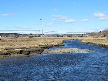
The Little River salt marsh in North Hampton, NH
|
|
| Country | United States |
| State | New Hampshire |
| County | Rockingham |
| Town | North Hampton |
| Physical characteristics | |
| Main source | North Hampton 70 ft (21 m) 42°59′57″N 70°49′20″W / 42.99917°N 70.82222°W |
| River mouth | Gulf of Maine (Atlantic Ocean) North Hampton 0 ft (0 m) 42°57′24″N 70°46′43″W / 42.95667°N 70.77861°W |
| Length | 4.6 mi (7.4 km) |
| Basin features | |
| Tributaries |
|
The Little River is a small river in southeastern New Hampshire, United States. It is about 4.6 mi (7.4 km) long. This river is special because it flows entirely within the town of North Hampton. It empties directly into the Atlantic Ocean.
Contents
The Little River's Journey
The Little River begins in a wetland area in northern North Hampton. A wetland is a type of land that is often covered with water, like a swamp or marsh. From there, the river flows south.
Flowing Through North Hampton
As it travels, the river passes under a major road called U.S. 1. Then, it turns towards the southeast. It flows through a place called Mill Pond. After that, it goes under another road, NH 111.
Reaching the Salt Marsh
Next, the Little River enters the Little River salt marsh. A salt marsh is a coastal wetland that is flooded by salty ocean water. It's an important home for many plants and animals.
Entering the Atlantic Ocean
Finally, the river reaches the Atlantic Ocean. It flows under NH 1A. Here, a large tunnel-like structure called a culvert helps the river pass. This culvert was put in place to help more ocean water flow into the salt marsh. This improved water flow is good for the marsh's health.
Images for kids
 | John T. Biggers |
 | Thomas Blackshear |
 | Mark Bradford |
 | Beverly Buchanan |


