
Greenland, New Hampshire facts for kids
Quick facts for kids
Greenland, New Hampshire
|
||
|---|---|---|

Community Congregational Church
|
||
|
||

Location in Rockingham County and the state of New Hampshire
|
||
| Country | United States | |
| State | New Hampshire | |
| County | Rockingham | |
| Incorporated | 1721 | |
| Area | ||
| • Total | 13.3 sq mi (34.5 km2) | |
| • Land | 10.5 sq mi (27.2 km2) | |
| • Water | 2.8 sq mi (7.3 km2) 21.29% | |
| Elevation | 59 ft (18 m) | |
| Population
(2020)
|
4,067 | |
| • Density | 388/sq mi (149.8/km2) | |
| Time zone | UTC-5 (Eastern) | |
| • Summer (DST) | UTC-4 (Eastern) | |
| ZIP code |
03840
|
|
| Area code(s) | 603 | |
| FIPS code | 33-31700 | |
| GNIS feature ID | 0873612 | |

Greenland is a town in New Hampshire, a state in the United States. It's located in Rockingham County. In 2020, about 4,067 people lived there. The town has a river called the Winnicut River and is next to Great Bay.
Contents
A Look at Greenland's Past
Greenland is one of the oldest settlements in New Hampshire. It started as a part of Portsmouth (which was then called Strawbery Banke) in 1638.
In 1640, Captain Francis Champernowne moved from Strawbery Banke. He settled in the area where the Portsmouth Country Club is today. He named his large farm "Greenland," even though it was first going to be called "Canary." Part of his land later became the town of Madbury.
Becoming Its Own Town
In 1706, the people of Greenland asked to become their own separate area, and their wish was granted. Around 1710, Captain Samuel Weeks built a strong brick house. This house is believed to be the oldest brick house still standing in New Hampshire.
The Weeks House survived a big earthquake in 1755. Only the thick beams that held the house up cracked a little. You can find a special sign about the Weeks House (historical marker number 113) along New Hampshire Route 33.
Greenland officially became an independent town in 1721. Later, in 1805 and 1847, it added parts of the nearby town of Stratham.
A Special Visitor
On September 1, 1824, a very important person visited Greenland. It was the Marquis de Lafayette, a French hero who helped the United States win its independence. The people of Greenland welcomed him with a special arch built in front of the local hotel.
Greenland's Location and Landscape
Greenland covers a total area of about 34.5 square kilometers (13.3 square miles). Most of this is land (27.2 square kilometers or 10.5 square miles), and about 7.3 square kilometers (2.8 square miles) is water. This means about 21% of the town is water!
The highest point in Greenland is Breakfast Hill. It's about 46 meters (151 feet) above sea level. This hill is on the border between Greenland and Rye.
Great Bay touches Greenland to the north. The Winnicut River is the main river that flows through the town. All of Greenland's water eventually flows into the Piscataqua River watershed, which leads to the ocean.
Neighboring Towns
Greenland shares its borders with several other towns:
- Newington (to the north)
- Portsmouth (to the east)
- Rye (to the southeast)
- North Hampton (to the south)
- Stratham (to the west)
- Newmarket (to the northwest)
People of Greenland
| Historical population | |||
|---|---|---|---|
| Census | Pop. | %± | |
| 1790 | 634 | — | |
| 1800 | 548 | −13.6% | |
| 1810 | 592 | 8.0% | |
| 1820 | 634 | 7.1% | |
| 1830 | 680 | 7.3% | |
| 1840 | 726 | 6.8% | |
| 1850 | 730 | 0.6% | |
| 1860 | 762 | 4.4% | |
| 1870 | 695 | −8.8% | |
| 1880 | 695 | 0.0% | |
| 1890 | 647 | −6.9% | |
| 1900 | 607 | −6.2% | |
| 1910 | 575 | −5.3% | |
| 1920 | 623 | 8.3% | |
| 1930 | 577 | −7.4% | |
| 1940 | 695 | 20.5% | |
| 1950 | 719 | 3.5% | |
| 1960 | 1,196 | 66.3% | |
| 1970 | 1,784 | 49.2% | |
| 1980 | 2,124 | 19.1% | |
| 1990 | 2,768 | 30.3% | |
| 2000 | 3,208 | 15.9% | |
| 2010 | 3,549 | 10.6% | |
| 2020 | 4,067 | 14.6% | |
| Historical Census Data | |||
In 2000, about 3,208 people lived in Greenland. There were 1,204 households, and 892 of them were families. The average household had about 2.65 people.
The population was spread out in terms of age:
- 26.5% were under 18 years old.
- 32.9% were between 25 and 44 years old.
- 10.1% were 65 years or older.
The average age in Greenland was 38 years.
Famous People from Greenland
Some notable people have connections to Greenland:
- Oney Judge (1773–1848): She was an enslaved person who escaped from the household of George Washington.
- John F. Richards (1938–2007): A historian who studied South Asia, especially the Mughal Empire.
- Benjamin F. Whidden (1813–1896): He was the first U.S. ambassador to Haiti.
Images for kids
-
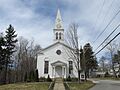
The Community Congregational Church in Greenland.
-

The official seal of the town of Greenland.
-
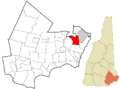
A map showing Greenland's location in Rockingham County, New Hampshire.
See also
 In Spanish: Greenland (Nuevo Hampshire) para niños
