Franconia Notch facts for kids
Quick facts for kids Franconia Notch |
|
|---|---|

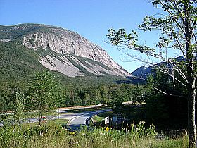
View of Franconia Notch, dominated by Cannon Mountain. A scree field can be seen at the bottom of the Cannon cliffs.
|
|
| Elevation | 1,950 ft (594 m) |
| Traversed by | Interstate 93, U.S. Route 3 |
| Location | Franconia / Lincoln, Grafton County, New Hampshire, United States |
| Range | White Mountains |
| Coordinates | 44°10′15″N 71°41′17″W / 44.1707°N 71.6881°W |
| Topo map | USGS Franconia (NH) |
| Designated: | 1971 |

Franconia Notch is a famous mountain pass in the White Mountains of New Hampshire. It sits at an elevation of about 1,950 feet (594 meters). This beautiful area is mostly found within Franconia Notch State Park.
The notch is surrounded by two huge mountains. To the west, you'll see Cannon Mountain. To the east, there's Mount Lafayette. A special highway, the Franconia Notch Parkway, runs through the pass. This parkway includes parts of Interstate 93 and U.S. Route 3.
Contents
What is Franconia Notch?
Franconia Notch is like a big valley or gap between mountains. It was carved out by glaciers long ago. This natural path makes it easier to travel through the rugged White Mountains.
The Old Man of the Mountain
For many years, Franconia Notch was home to a famous rock formation called the Old Man of the Mountain. This natural rock profile looked exactly like the face of an old man. It was a symbol of the state of New Hampshire. Sadly, the Old Man of the Mountain collapsed in 2003. Even though it's gone, its image is still a very important symbol for New Hampshire.
Where is Franconia Notch Located?
The notch is mainly in the town of Franconia. It also stretches south into the town of Lincoln. On its eastern side, you'll find the Franconia Ridge. This ridge includes several tall peaks.
- Mount Lafayette is about 5,249 feet (1,600 meters) tall.
- Mount Lincoln reaches about 5,089 feet (1,551 meters).
- Little Haystack Mountain is around 4,780 feet (1,457 meters) high.
On the western side, you'll see Cannon Mountain. It stands about 4,080 feet (1,244 meters) tall. Cannon Mountain has a very steep rock face called Cannon Cliff.
Lakes and Rivers in the Notch
The highest point of the notch is near the base of Cannon Mountain. Just north of this high point is Echo Lake. Water from Echo Lake flows into Lafayette Brook. This brook then joins the Gale River and the Ammonoosuc River. Finally, the water reaches the Connecticut River, which flows all the way to Long Island Sound.
South of the high point, you'll find Profile Lake. This lake sits right below where the Old Man of the Mountain used to be. Profile Lake is the starting point of the Pemigewasset River. This river is a main branch of the Merrimack River. The Merrimack River eventually flows into the Gulf of Maine.
The Franconia Notch Parkway
The Franconia Notch Parkway is a unique part of the Interstate 93 highway. It's special because it only has one lane in each direction. Usually, Interstate highways have more lanes. To build this parkway with fewer lanes, a special law had to be passed by the United States Congress. This was done to protect the natural beauty of Franconia Notch.
 | Chris Smalls |
 | Fred Hampton |
 | Ralph Abernathy |

