Mount Moosilauke facts for kids
Quick facts for kids Mount Moosilauke |
|
|---|---|

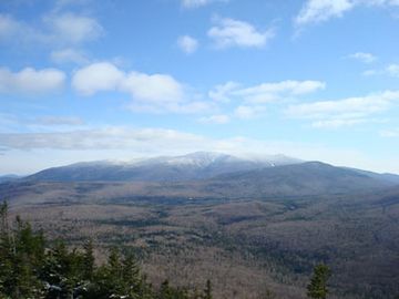
Mt. Moosilauke as seen from Black Mountain
|
|
| Highest point | |
| Elevation | 4,802 ft (1,464 m) |
| Prominence | 2,932 ft (894 m) |
| Listing | White Mountain 4000-Footers #9 New England 50 Finest |
| Geography | |
| Location | Grafton County, New Hampshire, U.S. |
| Parent range | White Mountains |
| Topo map | USGS Mount Moosilauke |

Mount Moosilauke is a tall mountain, about 4,802 feet (1,464 meters) high. It's located in the southwestern part of the White Mountains in Benton, New Hampshire, USA. It is one of the ten highest peaks in the White Mountains that are over 4,000 feet tall.
Moosilauke is also ranked 9th on the New England Fifty Finest peaks. This list includes mountains that stand out a lot from the land around them. The famous Appalachian Trail, a very long hiking path, goes right over the mountain's top. People sometimes call Mount Moosilauke the "Gentle Giant."
Contents
What's in a Name?
The name Moosilauke comes from the Abenaki language. This language was spoken by Native American tribes who lived in the area a long time ago. The most common meaning for the name is "bald place." This probably refers to the very top of the mountain, which doesn't have any trees.
However, figuring out the exact meaning of old place names can be tricky! Other ideas for what Moosilauke might mean include "at the place of ferns" or "good moose place along the brook."
What is Mount Moosilauke Made Of?
Mount Moosilauke is mostly made of a type of metamorphic rock called the Littleton Formation. Metamorphic rocks are rocks that have changed over time due to heat and pressure deep inside the Earth. This rock formed a very long time ago, during a period called the Lower Devonian.
The main rock here is a type of mica schist. This rock started out as clay-rich mud at the bottom of an ancient ocean. You can also find other minerals in it, like garnet. Sometimes, you might see darker rocks called amphibolites mixed in. These might have been ancient basalt flows from volcanoes under the sea.
As you hike up the Gorge Brook Trail, especially near the tree line, you might spot lighter-colored rock veins. These are called pegmatite dikes. They are like cracks in the mountain that filled with different kinds of rock.
Amazing Views from the Top
The very top of Mount Moosilauke has no trees, which means you get incredible, wide-open views! From the summit, you can see many other mountain ranges. To the north, you can spot the Kinsman Range. To the northeast, you'll see the Presidential Range and Franconia Ridge. The heart of the White Mountains stretches out to the east.
On a clear day, you can even see Lake Winnipesaukee and other lakes to the southeast. Looking west, you might catch a glimpse of the Green Mountains in Vermont and the Adirondacks in New York. The mountain also has deep, carved-out valleys called ravines.
A long time ago, in the winter of 1869-1870, the first weather observatory for high mountain areas was set up right on top of Mount Moosilauke.
Other Peaks on Moosilauke
Mount Moosilauke has a few smaller peaks nearby. One is Mount Blue, which is about 4,529 feet (1,380 meters) high, located north of the main summit. Another is the South Peak, about 4,523 feet (1,379 meters) high. This peak is about one mile southwest of the main summit.
You can reach the South Peak by taking a short 0.2-mile (0.3 km) side trail. It's a great spot to see the main summit ridge and look down into the deep Tunnel Brook Ravine. You can also see the Connecticut River valley and the state of Vermont from here.
Popular Hiking Trails
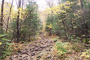
Many people enjoy hiking to the top of Mount Moosilauke. The most popular way to reach the summit is by taking the Gorge Brook Trail, which starts from the Ravine Lodge. Hikers often make a loop by coming back down using the Carriage Road and Snapper Trail.
Other trails that lead to the summit include:
- The Glencliff Trail, from the southwest.
- The Benton Trail, from the north.
- The Beaver Brook Trail, which is very steep and passes many waterfalls from Kinsman Notch to the northeast.
- The Carriage Road, from the south.
- The Asquam Ridge Trail, from the southeast.
The famous Appalachian Trail uses parts of the Glencliff, Carriage Road, Benton, and Beaver Brook trails as it crosses Mount Moosilauke.
Moosilauke Ravine Lodge
The Moosilauke Ravine Lodge is a special place located in the valley on the southeast side of the mountain. It offers food and a place to stay for hikers. Dartmouth College owns the lodge, and students from the Dartmouth Outing Club help run it.
Dartmouth College also owns a lot of the land on the southern and eastern parts of the mountain. The Dartmouth Outing Club has a long history of taking care of the hiking trails on Moosilauke, including parts of the Appalachian Trail. Because of this strong connection, Mount Moosilauke is often called "Dartmouth's Mountain."
 | Laphonza Butler |
 | Daisy Bates |
 | Elizabeth Piper Ensley |

