
Kinsman Notch facts for kids
Quick facts for kids Kinsman Notch |
|
|---|---|

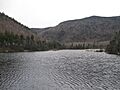
Beaver Pond near height of land in Kinsman Notch
|
|
| Elevation | 1,870 ft (570 m) |
| Traversed by | |
| Location | Woodstock, Grafton County, New Hampshire, United States |
| Range | White Mountains |
| Coordinates | 44°02′21″N 71°47′33″W / 44.0392°N 71.7925°W |
| Topo map | USGS Mount Moosilauke |
Kinsman Notch is a mountain pass located in the beautiful White Mountains of New Hampshire, United States. It sits at an elevation of about 1,870 feet (570 meters) above sea level. This notch is the westernmost of the big passes that cut through the White Mountains. Other famous notches include Franconia Notch, Crawford Notch, and Pinkham Notch.
Kinsman Notch is a special place where water flows in two different directions. The southeastern part of the notch is drained by the Lost River. This river flows into the Pemigewasset River, which then joins the Merrimack River. Finally, the Merrimack River empties into the Gulf of Maine in the Atlantic Ocean. The northwestern part of the notch is drained by Beaver Brook and the Wild Ammonoosuc River. These waters are part of the Connecticut River system, which eventually flows into Long Island Sound.
Contents
What is Kinsman Notch?
Kinsman Notch is a low point or a "pass" between two mountain areas. It lies between Mount Moosilauke to the southwest and Kinsman Ridge to the northeast. These natural passes are important because they allow roads and trails to cross through mountain ranges.
How Does the Appalachian Trail Cross Kinsman Notch?
The famous Appalachian Trail goes right through Kinsman Notch. This long hiking trail crosses the highest point of the notch as it travels between Mount Moosilauke and Kinsman Ridge. Hikers coming from Mount Moosilauke follow Beaver Brook Cascades. These are a series of waterfalls that drop a total of 1,200 feet (366 meters). It's a challenging but very scenic part of the trail.
Exploring the Lost River Reservation
One of the most exciting features in Kinsman Notch is the Lost River Reservation. This is a wild gorge filled with huge boulders. It's located on the floor of the notch, southeast of the highest point. The Lost River flows underground through caves and crevices formed by these giant rocks. Visitors can explore the gorge and see how the river disappears and reappears.
Traveling Through Kinsman Notch
New Hampshire Route 112 is a scenic road that travels right through Kinsman Notch. This route connects North Woodstock to Woodsville, New Hampshire. Driving through the notch offers beautiful views of the mountains and forests. It's a popular road for tourists exploring the White Mountains.
Images for kids
-
Beaver Pond near the height of land in Kinsman Notch
