Pinkham Notch facts for kids
Quick facts for kids Pinkham Notch |
|
|---|---|
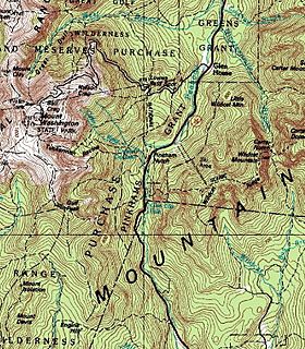
The steep, glacier-carved walls of Pinkham Notch can be seen in this topographic map.
|
|
| Elevation | 2,032 ft (619 m) |
| Traversed by | |
| Location | Pinkham's Grant, Coos County, New Hampshire, United States |
| Range | White Mountains |
| Coordinates | 44°15′27″N 71°15′13″W / 44.2576°N 71.2537°W |
| Topo map | USGS Stairs Mountain, Jackson, Carter Dome, Mount Washington |
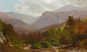
Pinkham Notch is a mountain pass in the White Mountains of New Hampshire, United States. It's like a big valley carved by ancient glaciers. These glaciers, huge sheets of ice, shaped the land during the Ice Age, making the valley U-shaped.
The sides of Pinkham Notch are formed by tall mountain ranges: the Presidential, Wildcat, and Carter-Moriah mountains. Because the weather here can change a lot and the land is rugged, special plants and animals live in this area.
People first wrote about Pinkham Notch in 1784. For a long time, it was hard to get to. But when New Hampshire Route 16 was built, it became much easier to visit. Now, it's a popular spot for hiking and skiing.
Contents
Exploring Pinkham Notch's Geography
Pinkham Notch separates the Presidential Range on its west side from the Wildcat Range on its east side. Two rivers flow through the notch. The Ellis River drains the southern part and flows into the Saco. The Peabody River drains the northern part and flows into the Androscoggin.
The Western Mountains: Presidential Range
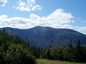
The western side of Pinkham Notch is mostly made up of Mount Washington. This is the tallest mountain in the northeastern United States, standing over 6,200 feet (1,900 meters) high. Mount Washington rises more than 4,000 feet (1,200 meters) above the valley floor.
You can find several bowl-shaped valleys called cirques on this side of the notch. The Great Gulf is the largest cirque in the White Mountains. South of it is Huntington Ravine, known for its steep, rocky walls that are great for climbing. Then there's the Ravine of Raymond Cataract, which has a cool waterfall. After that comes Tuckerman Ravine, famous for its smooth walls and excellent skiing.
The Eastern Mountains: Wildcat and Carter-Moriah Ranges
The eastern side of Pinkham Notch has the Wildcat and Carter-Moriah Ranges. These mountains are a bit lower than the Presidential Range. The Wildcat Range has five peaks, named A, B, C, D, and E. Wildcat A is the tallest at 4,422 feet (1,348 meters). The slopes here drop very steeply down to the notch floor.
The Wildcat Mountain Ski Area is located on the western slopes of Wildcat Mountain. As you go further north, the Carter-Moriah Range forms the eastern side of Pinkham Notch. Some of the peaks in this range include Carter Dome (4,832 feet / 1,473 meters) and Mount Moriah (4,049 feet / 1,234 meters).
Understanding Pinkham Notch's Climate
The weather in Pinkham Notch changes a lot depending on how high up you are and which way the land faces. A weather station has been recording data here since 1930.
Pinkham Notch has a humid continental climate. This means it has warm summers and cold, snowy winters. The hottest temperature ever recorded here was 93°F (34°C) on July 20, 1982. The coldest was -32°F (-36°C) on February 16, 1943.
| Climate data for Pinkham Notch, New Hampshire, 1991–2020 normals, extremes 1930–present (elevation 2025 ft.) | |||||||||||||
|---|---|---|---|---|---|---|---|---|---|---|---|---|---|
| Month | Jan | Feb | Mar | Apr | May | Jun | Jul | Aug | Sep | Oct | Nov | Dec | Year |
| Record high °F (°C) | 64 (18) |
72 (22) |
78 (26) |
86 (30) |
90 (32) |
91 (33) |
93 (34) |
92 (33) |
92 (33) |
86 (30) |
75 (24) |
67 (19) |
93 (34) |
| Mean maximum °F (°C) | 48.9 (9.4) |
49.1 (9.5) |
56.6 (13.7) |
71.1 (21.7) |
80.6 (27.0) |
85.0 (29.4) |
85.8 (29.9) |
84.4 (29.1) |
82.2 (27.9) |
73.4 (23.0) |
61.8 (16.6) |
52.3 (11.3) |
88.3 (31.3) |
| Mean daily maximum °F (°C) | 26.0 (−3.3) |
28.4 (−2.0) |
36.2 (2.3) |
48.5 (9.2) |
61.9 (16.6) |
70.0 (21.1) |
75.0 (23.9) |
74.0 (23.3) |
67.5 (19.7) |
54.4 (12.4) |
41.8 (5.4) |
31.5 (−0.3) |
51.3 (10.7) |
| Daily mean °F (°C) | 16.1 (−8.8) |
17.9 (−7.8) |
25.6 (−3.6) |
37.9 (3.3) |
50.2 (10.1) |
58.9 (14.9) |
64.0 (17.8) |
62.8 (17.1) |
56.3 (13.5) |
44.6 (7.0) |
33.1 (0.6) |
22.6 (−5.2) |
40.8 (4.9) |
| Mean daily minimum °F (°C) | 6.2 (−14.3) |
7.3 (−13.7) |
14.9 (−9.5) |
27.3 (−2.6) |
38.5 (3.6) |
47.9 (8.8) |
53.1 (11.7) |
51.5 (10.8) |
45.0 (7.2) |
34.8 (1.6) |
24.4 (−4.2) |
13.7 (−10.2) |
30.4 (−0.9) |
| Mean minimum °F (°C) | −13.0 (−25.0) |
−9.8 (−23.2) |
−4.7 (−20.4) |
16.1 (−8.8) |
28.5 (−1.9) |
37.0 (2.8) |
43.4 (6.3) |
41.8 (5.4) |
32.3 (0.2) |
22.8 (−5.1) |
9.0 (−12.8) |
−4.9 (−20.5) |
−15.4 (−26.3) |
| Record low °F (°C) | −31 (−35) |
−32 (−36) |
−21 (−29) |
−4 (−20) |
10 (−12) |
29 (−2) |
32 (0) |
31 (−1) |
21 (−6) |
8 (−13) |
−7 (−22) |
−31 (−35) |
−32 (−36) |
| Average precipitation inches (mm) | 5.31 (135) |
4.28 (109) |
4.87 (124) |
5.75 (146) |
5.48 (139) |
5.88 (149) |
5.48 (139) |
5.12 (130) |
4.99 (127) |
7.82 (199) |
5.83 (148) |
5.98 (152) |
66.79 (1,697) |
| Average snowfall inches (cm) | 28.5 (72) |
27.6 (70) |
26.4 (67) |
9.4 (24) |
0.6 (1.5) |
0.0 (0.0) |
0.0 (0.0) |
0.0 (0.0) |
0.0 (0.0) |
1.7 (4.3) |
12.7 (32) |
28.9 (73) |
135.8 (343.8) |
| Average precipitation days (≥ 0.01 in) | 14.3 | 12.7 | 13.3 | 13.0 | 14.8 | 14.3 | 14.1 | 13.1 | 11.5 | 14.2 | 13.9 | 16.0 | 165.2 |
| Average snowy days (≥ 0.1 in) | 10.8 | 10.6 | 9.4 | 4.3 | 0.3 | 0.0 | 0.0 | 0.0 | 0.0 | 1.2 | 5.5 | 11.2 | 53.3 |
| Source 1: NOAA | |||||||||||||
| Source 2: National Weather Service | |||||||||||||
Nature and Wildlife in Pinkham Notch
The plants and animals in Pinkham Notch change a lot as you go higher up the mountains. The climate gets colder, and the types of ecosystems change. You can find everything from forests like those in northern areas to plants that grow in Arctic regions near the mountaintops.
Forests at Lower Elevations: Northern Hardwood
At the lowest parts of Pinkham Notch, you'll find a northern hardwood forest. Most of these trees lose their leaves in the fall. Common trees include sugar maple, American beech, and yellow birch. Many smaller plants grow on the forest floor, like wild sarsaparilla and painted trillium.
This forest is home to many animals. You might see chipmunks, raccoons, white-tailed deer, black bears, and moose. Lots of birds live here too, such as red-eyed vireos and hermit thrushes. Amphibians like American toads and wood frogs are also common.
As you go higher, around 2,000 feet (610 meters), other tree types start to mix in. By 2,500 feet (760 meters), the forest changes to mostly spruce and fir trees.
Mid-Elevation Forests: Spruce and Fir
Higher up, the weather gets colder, and the soil is more acidic. This is where conifer trees, also called "softwoods," grow best. You'll see red spruce and balsam fir trees here. Some other trees like paper birch can be found lower in this zone.
Many of the same animals from the hardwood forest also live here. Warblers are very common birds. You might also spot brown-capped chickadees and spruce grouse. Mammals include the red squirrel and the pine marten.
High-Elevation Forests: Balsam Fir and Krummholz
Even higher up, only the toughest trees can survive. This forest is almost entirely made of balsam fir trees. The strong winds and cold temperatures here make the trees grow in strange, twisted shapes. This is called krummholz, which means "crooked wood" in German.
Trees in krummholz areas are often bent by the wind and ice. Branches facing the wind might even die, leaving "flag trees" that point in the direction the wind usually blows. Eventually, it gets too harsh for any trees to grow. This point is called the tree line, usually around 4,500 feet (1,400 meters) in the White Mountains.
Above the Trees: The Alpine Zone
Above the tree line, no trees can grow. This area is called the "alpine zone" and has plants similar to those found in the Arctic. You'll see lichens, grasses, and small, low-lying plants that can handle the constant wind. Most of these plants live for many years because the growing season is very short.
Alpine plants often grow in small groups between rocky slopes. Some plants, like Diapensia lapponica, grow in cushion shapes in windy spots. In more sheltered areas, you might find sedges, heaths, and plants that grow near snow patches.
A Look Back: Pinkham Notch's History
Pinkham Notch was originally a V-shaped valley carved by a river. But then, a huge ice sheet called the Laurentide Ice Sheet came through during the Wisconsinian Ice Age, about 25,000 to 50,000 years ago. This ice sheet reshaped the valley into the U-shape we see today. The glaciers also left behind large rocks called glacial erratics, like the Glen Boulder near Mount Washington.
The first time Pinkham Notch was written about was in 1784. An expedition led by Jeremy Belknap camped there before climbing Mount Washington. Pinkham Notch was very isolated back then. The first settler, Hayes Copp, built a home there in 1827.
In 1836, Daniel Pinkham built the first road through the notch, connecting Copp's home to other towns. Later, in 1851, a railroad was built to Gorham, and a hotel called the Glen House opened. Mount Washington became a big attraction. A path was built from the Glen House to the summit, which later became the Mount Washington Auto Road. When the road was finished in 1861, many more tourists started visiting.
Logging was also a big industry in the Pinkham area. After much of the White Mountains were deforested, the White Mountain National Forest was created in 1911 to protect the land. The focus then shifted from logging to outdoor fun. In 1921, the Appalachian Mountain Club turned an old logging camp into the Pinkham Notch Visitor Center. The Appalachian Trail runs through here, making it a key starting point for climbing Mount Washington. Ski trails were built on Wildcat Mountain, and the Wildcat Mountain Ski Area opened in 1958.
Fun Things to Do in Pinkham Notch
Pinkham Notch is easy to get to using New Hampshire Route 16. There are many ways to have fun here!
Hiking Adventures
Climbing Mount Washington is a popular goal from Pinkham Notch. Many trails start from the Appalachian Mountain Club's visitor center. Even though the trails might look short, climbing Mount Washington is a big challenge. You'll climb over 4,000 feet (1,200 meters) up rocky slopes. The weather can change very quickly, so hikers need to be prepared for extreme conditions.
The Tuckerman Ravine Trail is the most popular way to reach the summit. The Huntington Ravine Trail is considered the hardest trail in New Hampshire, with steep, rocky sections perfect for rock climbing.
On the other side of the notch, the Wildcat Range is also a favorite for hikers. The five peaks can be reached by the Wildcat Ridge Trail. This trail has some difficult, rocky parts.
The Appalachian Trail, a very long hiking trail, goes along the Presidential Range, crosses the notch, and then climbs the Wildcat Range.
If you're looking for easier hikes, there are beautiful options for families. You can visit Glen Ellis Falls, a waterfall on the Ellis River, or Square Ledge, which offers great views of Mount Washington.
Skiing and Snowboarding
Pinkham Notch is a fantastic place for both downhill and cross-country skiing. Tuckerman Ravine is famous for its extremely steep backcountry skiing. Many people visit in April and May for spring skiing. Wildcat Mountain has groomed ski trails and lifts, which are great for all skill levels. In the summer, you can ride the gondola at Wildcat for amazing views of the Presidential Mountains without any effort.
For cross-country skiing, Great Glen Trails offers a large system of groomed trails. You can even ski on the lower part of the Auto Road. There are warming huts along the trails, like the scenic Great Angel Cabin, which has views of the Great Gulf. Great Glen also allows mountain biking on its trails in the summer. Another cross-country trail system is in the town of Jackson.
See also
 | Isaac Myers |
 | D. Hamilton Jackson |
 | A. Philip Randolph |


