
Jackson, New Hampshire facts for kids
Quick facts for kids
Jackson, New Hampshire
|
||
|---|---|---|
|
Town
|
||
 |
||
|
||
| Motto(s):
"Bridging the Centuries"
|
||

Location in Carroll County, New Hampshire
|
||
| Country | United States | |
| State | New Hampshire | |
| County | Carroll | |
| Incorporated | December 4, 1800 | |
| Area | ||
| • Total | 66.8 sq mi (173.0 km2) | |
| • Land | 66.8 sq mi (172.9 km2) | |
| • Water | 0.04 sq mi (0.1 km2) 0.06% | |
| Elevation | 758 ft (231 m) | |
| Population
(2020)
|
||
| • Total | 1,028 | |
| • Density | 15/sq mi (5.9/km2) | |
| Time zone | UTC-5 (Eastern) | |
| • Summer (DST) | UTC-4 (Eastern) | |
| ZIP code |
03846
|
|
| Area code(s) | 603 | |
| FIPS code | 33-38260 | |
| GNIS feature ID | 0873632 | |

Jackson is a small town in Carroll County, New Hampshire, United States. It's known as a popular vacation spot in the beautiful White Mountains. In 2020, about 1,028 people lived there. Parts of the White Mountain National Forest are located around Jackson.
Contents
History of Jackson
Jackson was first made up of large pieces of land given out by the colonial Governor John Wentworth. It was first called "New Madbury." In 1772, a road was built through Pinkham Notch, and the first settlers arrived in 1778. Benjamin Copp and his family were among the first to live there.
In 1800, the community was renamed "Adams" to honor President John Adams, who was in office at the time. This name stayed until 1829. When Andrew Jackson, a famous hero from the Battle of New Orleans, became president, the town was renamed "Jackson." Governor Benjamin Pierce, a strong supporter of President Jackson, helped make this change happen. Only one person voted against it!
In 2021, the people of Jackson voted to change the town's dedication. Now, the town honors geologist Charles Thomas Jackson (1805–1880) instead of Andrew Jackson.
Jackson as an Art and Tourist Spot
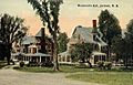
Starting in 1847, artists from the White Mountain School came to Jackson. They wanted to paint the amazing scenery of the White Mountains. More people followed, and in 1858, Joshua B. Trickey opened the Jackson Falls House.
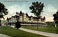
In the early 1870s, the Portland & Ogdensburg Railroad started bringing trains to nearby Glen station. This made it easier for tourists to visit, and several hotels were built. The Thorn Mountain House, built by Trickey in 1869, later became Wentworth Hall. This hotel is still open today! It was designed with cottages around a main building and even had a casino and its own power plant. By the 1920s, 40 trains a day brought visitors to Jackson.
However, as more people started using automobiles, fewer traveled by train. This meant some of the big 19th-century hotels closed down. But Jackson itself never lost its popularity. It's known as one of the most beautiful villages in the region.
Fun Things to Do in Jackson
Jackson is famous for its natural beauty and outdoor activities. You can visit Jackson Falls, a beautiful waterfall. The town also has Jackson X-C, a 100-kilometer cross-country skiing trail system. It's considered one of the best in the world!
Wildcat Mountain is a popular place for alpine skiing. It offers an amazing view of Mount Washington. Vail Resorts bought Wildcat Mountain in 2019.
Perhaps the most famous landmark in Jackson is its red covered bridge, built in 1876. It's often called the Honeymoon Bridge and is one of the most photographed bridges in New Hampshire.
-
Wentworth Hall c. 1912
-
Thorn Mountain in 1912
-
Gray's Inn in 1907
-
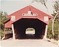
Honeymoon Bridge in October 1982


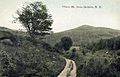
Geography and Nature
Jackson covers about 173.0 square kilometers (66.8 square miles) of land. Only a tiny part, about 0.1 square kilometers (0.04 square miles), is water. The town is watered by the Ellis River and its smaller stream, Wildcat Brook.
The highest point in Jackson is 3,870 feet (1,180 meters) above sea level on Wildcat Ridge. This ridge continues to rise north of the town, leading to the summit of Wildcat Mountain. Jackson is part of the Saco River watershed, meaning all its water flows into the Saco River.
Neighboring Towns
Jackson shares its borders with several other towns and areas:
- Bean's Purchase (to the north)
- Chatham (to the east)
- Bartlett (to the south)
- Sargent's Purchase (to the west)
- Pinkham's Grant (to the northwest)
People of Jackson
| Historical population | |||
|---|---|---|---|
| Census | Pop. | %± | |
| 1850 | 589 | — | |
| 1860 | 631 | 7.1% | |
| 1870 | 474 | −24.9% | |
| 1880 | 464 | −2.1% | |
| 1890 | 579 | 24.8% | |
| 1900 | 624 | 7.8% | |
| 1910 | 452 | −27.6% | |
| 1920 | 533 | 17.9% | |
| 1930 | 321 | −39.8% | |
| 1940 | 409 | 27.4% | |
| 1950 | 344 | −15.9% | |
| 1960 | 315 | −8.4% | |
| 1970 | 404 | 28.3% | |
| 1980 | 642 | 58.9% | |
| 1990 | 678 | 5.6% | |
| 2000 | 835 | 23.2% | |
| 2010 | 816 | −2.3% | |
| 2020 | 1,028 | 26.0% | |
| U.S. Decennial Census | |||
In 2000, there were 835 people living in Jackson. These people lived in 377 households, and 240 of those were families. The population density was about 12.5 people per square mile. Most of the people living in Jackson were White (99.28%).
About 21% of households had children under 18. Most households (57.8%) were married couples living together. The average household had 2.18 people, and the average family had 2.67 people.
The population of Jackson is spread out across different age groups. About 18% were under 18, and 21.8% were 65 or older. The average age in town was 46 years old.
The median income for a household in Jackson was $49,583. This means half the households earned more than this, and half earned less. For families, the median income was $59,327. The average income per person in the town was $25,718. About 8.1% of the population lived below the poverty line.
Images for kids
-
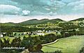
Bird's-eye view of Jackson in 1907
-
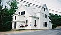
The Old Town Hall in 2001
-
Fairview Bridge in 1912


See also
 In Spanish: Jackson (Nuevo Hampshire) para niños
