Chatham, New Hampshire facts for kids
Quick facts for kids
Chatham, New Hampshire
|
|
|---|---|
|
Town
|
|

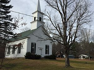
Chatham Congregational Church in Chatham village
|
|

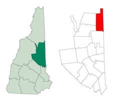
Location in Carroll County, New Hampshire
|
|
| Country | United States |
| State | New Hampshire |
| County | Carroll |
| Incorporated | 1767 |
| Villages |
|
| Area | |
| • Total | 57.3 sq mi (148.3 km2) |
| • Land | 56.7 sq mi (146.9 km2) |
| • Water | 0.5 sq mi (1.4 km2) 0.96% |
| Elevation | 521 ft (159 m) |
| Population
(2020)
|
|
| • Total | 341 |
| • Density | 5.955/sq mi (2.299/km2) |
| Time zone | UTC-5 (Eastern) |
| • Summer (DST) | UTC-4 (Eastern) |
| ZIP code |
03813
|
| Area code(s) | 603 |
| FIPS code | 33-11780 |
| GNIS feature ID | 0873563 |
Chatham is a small town located in Carroll County, New Hampshire, in the United States. In 2020, about 341 people lived there.
Chatham is nestled in the beautiful White Mountains. Most of the town is actually inside the White Mountain National Forest. It's also home to the Cold River national forest campgrounds, a great spot for outdoor adventures.
Contents
History of Chatham
Chatham was officially created on February 7, 1767. This happened when colonial Governor Benning Wentworth gave the land to Peter Livins and others. The town was named after William Pitt, who was the Prime Minister of Great Britain. He had recently led Britain to victory in a big war called the Seven Years' War.
In 1770, the town was granted again by Governor John Wentworth, who was William Pitt's nephew. This time, a group including Samuel Langdon received the grant. Samuel Langdon was the president of Harvard College and created an important map of the northern region. Later, in 1829, a part of Conway was added to Chatham.
Geography of Chatham
Chatham covers a total area of about 148.3 square kilometers (57.3 square miles). Most of this area, about 146.9 square kilometers (56.7 square miles), is land. The rest, 1.4 square kilometers (0.5 square miles), is water.
The highest point in Chatham is the top of South Baldface mountain. It stands at about 1,081 meters (3,547 feet) above sea level. Other notable mountains include Sable Mountain to the west and Robbins Ridge, which crosses the middle of town. You can also find Upper Kimball Pond and Basin Pond here. All the water in Chatham eventually flows into the Saco River.
In 1875, a book called Statistics and Gazetteer of New-Hampshire described Chatham's unique geography. It mentioned that Carter's Mountain is so tall between Chatham and Jackson that it's hard to build a direct road. Because of this, people often have to travel through a part of Maine to get between the two New Hampshire towns.
The book also talked about Kiarsarge (now Kearsarge North) mountain, which had a house for visitors at its top. The views from this mountain were described as "grand and very extensive." From the top of Baldface Mountain, you could even see the Tip-Top House on Mount Washington and the ocean!
Today, Kearsarge North and Baldface are mostly reached by hiking trails. Kearsarge North still has a lookout tower, and the views are still amazing. To get to Jackson from Chatham, people still often drive south on Maine State Route 113 through Fryeburg, then west through Conway. Route 113 also goes north from Chatham, crossing into Maine again through Evans Notch before reaching U.S. Route 2 in Gilead, Maine.
Chatham is almost like an enclave, meaning it's mostly surrounded by another state (Maine). This makes it unique because to reach other towns in New Hampshire, you often have to drive through Maine first!
Towns and Cities Nearby
Chatham is bordered by these towns and areas:
- Bean's Purchase (to the north)
- South Oxford, Maine (to the northeast)
- Stow, Maine (to the east)
- Fryeburg, Maine (to the southeast)
- Conway (to the south)
- Bartlett (to the southwest)
- Jackson (to the west)
Population Information
| Historical population | |||
|---|---|---|---|
| Census | Pop. | %± | |
| 1790 | 58 | — | |
| 1800 | 183 | 215.5% | |
| 1810 | 201 | 9.8% | |
| 1820 | 298 | 48.3% | |
| 1830 | 419 | 40.6% | |
| 1840 | 523 | 24.8% | |
| 1850 | 516 | −1.3% | |
| 1860 | 489 | −5.2% | |
| 1870 | 445 | −9.0% | |
| 1880 | 421 | −5.4% | |
| 1890 | 329 | −21.9% | |
| 1900 | 267 | −18.8% | |
| 1910 | 209 | −21.7% | |
| 1920 | 229 | 9.6% | |
| 1930 | 168 | −26.6% | |
| 1940 | 184 | 9.5% | |
| 1950 | 177 | −3.8% | |
| 1960 | 150 | −15.3% | |
| 1970 | 134 | −10.7% | |
| 1980 | 189 | 41.0% | |
| 1990 | 268 | 41.8% | |
| 2000 | 260 | −3.0% | |
| 2010 | 337 | 29.6% | |
| 2020 | 341 | 1.2% | |
| U.S. Decennial Census | |||
Based on the census from 2000, there were 260 people living in Chatham. These people made up 107 households and 71 families. The population density was about 4.6 people per square mile. There were 253 housing units in the town.
Most of the people in Chatham (98.08%) were White. A small percentage (1.15%) were from other races, and 0.77% were from two or more races.
Out of the 107 households:
- 29.0% had children under 18 living with them.
- 57.0% were married couples living together.
- 5.6% had a female head of household with no husband present.
- 33.6% were not families (single people or roommates).
About 27.1% of all households were individuals living alone. And 8.4% of households had someone aged 65 or older living by themselves. The average household had 2.43 people, and the average family had 2.94 people.
The town's population had a mix of ages:
- 24.6% were under 18 years old.
- 4.2% were between 18 and 24.
- 30.0% were between 25 and 44.
- 30.4% were between 45 and 64.
- 10.8% were 65 years old or older.
The average age in Chatham was 41 years. For every 100 females, there were about 106.3 males.
In 2000, the average income for a household in Chatham was $37,188 per year. For families, the average income was $40,156. Men earned an average of $22,188, while women earned $20,313. The per capita income (income per person) for the town was $15,317. About 15.4% of the total population lived below the poverty line. This included 23.9% of those under 18, but none of those aged 65 or older.
See also
 In Spanish: Chatham (Nuevo Hampshire) para niños
 | James Van Der Zee |
 | Alma Thomas |
 | Ellis Wilson |
 | Margaret Taylor-Burroughs |

