Presidential Range facts for kids
Quick facts for kids Presidential Range |
|
|---|---|

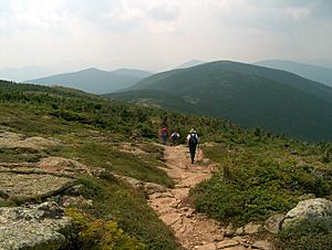
The Presidential Range viewed from Pinkham Notch
|
|
| Highest point | |
| Peak | Mount Washington |
| Elevation | 6,288 ft (1,917 m) |
| Naming | |
| Etymology | U.S. presidents |
| Geography | |
| Country | United States |
| State | New Hampshire |
| Region | New England |
| Parent range | White Mountains |
The Presidential Range is a group of mountains found in the White Mountains of New Hampshire, a state in the United States. This range includes some of the highest peaks in the White Mountains. Many of its most famous mountain tops are named after American presidents. Other peaks are named after important public figures from the 1700s and 1800s.
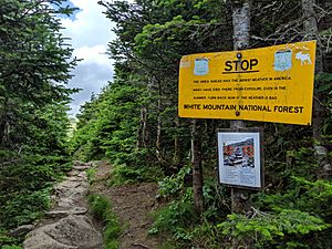
The Presidential Range is famous for having some of the most extreme weather on Earth. This is mainly because of very strong, sudden winds and "whiteout" conditions. Whiteout means it's so snowy and foggy you can't see anything. Because of these tough weather conditions, the Presidential Range is a popular place for mountain climbers to train. They prepare here for climbing some of the world's tallest mountains, like K2 and Mount Everest.
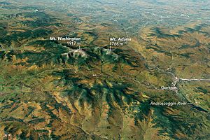
Mount Washington is the tallest mountain in the range, standing at 6,288 ft (1,917 m). It once held the world record for the highest wind speed ever recorded on Earth's surface, at 231 mph (372 km/h). Next to it are Mount Adams, which is 5,793 ft (1,766 m) tall, and Mount Jefferson, at 5,712 ft (1,741 m). Most of the Presidential Range is located in Coos County.
Contents
Discovering the Presidential Peaks
The highest mountains in the Presidential Range are mostly named after U.S. presidents. For example, the tallest mountain, Mount Washington, is named after the first president. The second tallest, Mount Adams, is named after the second president, and so on. However, there was a mistake when the mountains were measured. Mount Monroe is actually 22 feet (6.7 m) taller than Mount Madison. This means they are not in the correct order of presidents.
Here are some of the most well-known mountain tops in the range, listed from southwest to northeast:
- Mount Webster — named after Daniel Webster
- Mount Jackson* — named after Charles Thomas Jackson, a geologist from the 1800s
- Mount Pierce* — named after Franklin Pierce. It used to be called Mount Clinton, after DeWitt Clinton.
- Mount Eisenhower* — named after Dwight D. Eisenhower
- Mount Franklin — named after Benjamin Franklin
- Mount Monroe* — named after James Monroe
- Mount Washington* — named after George Washington. He was a general when the mountain was named in 1784, and later became president.
- Mount Clay — named after Henry Clay. The state of New Hampshire changed its name to Mount Reagan after Ronald Reagan, but the U.S. government still uses the name Clay.
- Mount Jefferson* — named after Thomas Jefferson
- Mount Sam Adams — named after Samuel Adams
- Mount Adams* — named after John Adams
- Mount Quincy Adams — named after John Quincy Adams
- Mount Madison* — named after James Madison
Mount Adams also has four smaller peaks that are well-known. Two of them are Sam Adams and John Quincy Adams, mentioned above. The other two are:
- Mount Abigail Adams
- Adams V
The mountains marked with an asterisk (*) are part of a special list for hikers. This list includes mountains in New Hampshire that are 4,000 feet or taller. Some mountains are not on the list because they are not tall enough, or because of other rules.

Other Important Summits

Besides the main presidential peaks, the range has other named mountains. Some of these peaks are harder to reach. They are on the west side of the range and are drained by the Dry River.
Here are some of the other important peaks:
- Peaks near Mount Washington:
- Ball Crag (6,106 ft)
- Nelson Crag (5,620 ft)
- Boott Spur (5,500 ft)
- North of Mount Washington:
- Mount Bowman (3,449 ft)
- South of Mount Washington:
- Mount Isolation (4,004 ft)*
- Mount Davis (3,819 ft)
- Stairs Mountain (3,463 ft)
- Mount Resolution (3,415 ft)
- Mount Crawford (3,119 ft)
- Mount Hope (2,505 ft)
- Mount Parker (3,004 ft)
The mountains marked with an asterisk (*) are also on the list of 4,000-foot and higher mountains in New Hampshire.
Waterways and Rivers
The Presidential Range helps separate different water systems. On one side, water flows into the Saco and Androscoggin rivers. These rivers eventually reach the Atlantic Ocean near the coast of Maine. On the other side, water flows into the Israel and Ammonoosuc rivers. These then join the Connecticut River, which flows into Long Island Sound.
The Presidential Traverse Hike
The Presidential Traverse is a famous hike that goes across all the main mountain tops along the Presidential ridge. This hike is about 19 miles (31 km) long and involves climbing over 8,500 feet (2,600 m) in total elevation. During the summer, experienced hikers can complete it in one day. In winter, it usually takes two to four days because of the difficult conditions. This hike is considered very challenging.
Mountain Safety and Weather
The Presidential Range is known for its sudden and harsh weather. It has some of the most dangerous mountains in the continental United States. Because of its unique location, it holds the world record for the highest recorded surface wind speed outside of a tropical storm. Most accidents in this area happen on Mount Washington, the highest peak. The New Hampshire Fish and Game Department helps about 200 hikers each year who need rescue. Always check the weather forecast and be prepared before hiking here!
See also
 In Spanish: Cordillera Presidencial para niños
 | Delilah Pierce |
 | Gordon Parks |
 | Augusta Savage |
 | Charles Ethan Porter |


