Mount Jefferson (New Hampshire) facts for kids
Quick facts for kids Mount Jefferson |
|
|---|---|

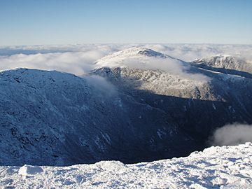
Mount Jefferson as seen from near the summit of Mount Washington, with the Great Gulf below.
|
|
| Highest point | |
| Elevation | 5,712 ft (1,741 m) |
| Prominence | 742 ft (226 m) |
| Listing | White Mountain 4000-Footers |
| Geography | |
| Location | Thompson and Meserve's Purchase, Coös County, New Hampshire, U.S. |
| Parent range | Presidential Range |
| Topo map | USGS Mount Washington |
| Climbing | |
| Easiest route | Caps Ridge Trail |
Mount Jefferson is a tall mountain in New Hampshire, USA. It is the third highest mountain in the state. This mountain is named after Thomas Jefferson, who was the third president of the United States. Mount Jefferson is part of the Presidential Range, which is a group of mountains in the White Mountains. It stands between Mount Adams to the northeast and Mount Clay to the south.
Discover Mount Jefferson
Mount Jefferson is a popular spot for hikers. It has many interesting natural features. Two main ridges lead up to its top: the Ridge of the Caps and Castle Ridge. These ridges offer different paths for climbers.
What Makes Mount Jefferson Special?
The mountain is surrounded by three big, bowl-shaped valleys. These valleys are called cirques. They were carved out by glaciers a long time ago. These cirques are named Jefferson Ravine, Castle Ravine, and the Great Gulf.
Near the very top of the mountain, there is a large, flat area called Monticello Lawn. This area is covered with special grasses and plants. Most of the summit is covered in loose rocks, called talus. From the Mount Washington Auto Road, you can see a unique arrow-shaped bare spot on Jefferson. This spot points right to its summit.
Hiking to the Top
One of the most direct ways to climb Mount Jefferson is using the Caps Ridge Trail. The starting point for this trail is Jefferson Notch. This is the highest public road in New Hampshire, at about 917 meters (3,009 feet) high.
The Caps Ridge Trail gains about 823 meters (2,700 feet) in height. This makes it the shortest climb to the top of any mountain in the Presidential Range, about 4 kilometers (2.5 miles) long. However, the trail can be challenging. Hikers need to climb over rocky sections, which can be steep and exposed to the weather.
 | Kyle Baker |
 | Joseph Yoakum |
 | Laura Wheeler Waring |
 | Henry Ossawa Tanner |

