
Thompson and Meserve's Purchase, New Hampshire facts for kids
Quick facts for kids
Thompson and Meserve's Purchase,
New Hampshire |
|
|---|---|
_in_Thompson_and_Meserve%27s_Purchase_Township,_Coos_County,_New_Hampshire.jpg)
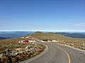
A large portion of the Mount Washington Auto Road passes through the township.
|
|

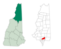
Location in Coös County, New Hampshire
|
|
| Country | United States |
| State | New Hampshire |
| County | Coös |
| Area | |
| • Total | 18.5 sq mi (48.0 km2) |
| • Land | 18.5 sq mi (48.0 km2) |
| • Water | 0 sq mi (0.0 km2) 0% |
| Elevation | 3,179 ft (969 m) |
| Population
(2020)
|
|
| • Total | 1 |
| Time zone | UTC-5 (Eastern) |
| • Summer (DST) | UTC-4 (Eastern) |
| Area code(s) | 603 |
| FIPS code | 33-007-76580 |
| GNIS feature ID | 872800 |
Thompson and Meserve's Purchase is a special kind of area called a township. It is located in Coös County, New Hampshire, in the United States. This entire area is found within the White Mountain National Forest.
What makes this place unique is its population. According to the 2020 census, only one person lives here!
In New Hampshire, "purchases" and "townships" are different from regular towns. They are parts of a county that don't have much self-government. Many of them, like this one, have very few or no people living there.
Thompson and Meserve's Purchase is famous because it covers the northern side of Mount Washington. This includes a big part of the Mount Washington Auto Road and the Cog Railway, which are popular ways to explore the mountain.
Contents
History of Thompson and Meserve's Purchase
How the Purchase Got Its Name
Thompson and Meserve's Purchase was bought a long time ago. In 1835, a person named Commissioner Willey sold this land. He sold it to two men: Samuel W. Thompson from Conway and George P. Meserve from Jackson, New Hampshire. They paid $500 for the land. That's how the area got its name, combining their last names.
Exploring the Geography of the Purchase
Where is Thompson and Meserve's Purchase Located?
This purchase is found just north of the top of Mount Washington. It includes a large part of the northern Presidential Range. This mountain range has some of the tallest peaks in New Hampshire.
Famous Mountains in the Area
Two very tall mountains are located here:
- Mount Adams: This is the second highest mountain in New Hampshire. It stands at about 5,774 feet (1,760 meters) tall.
- Mount Jefferson: This is the third highest peak. It reaches about 5,712 feet (1,741 meters) high.
The highest point within the purchase itself is about 6,000 feet (1,829 meters) above sea level. This spot is on the side of Chandler Ridge, just north of Mount Washington's summit.
Unique Landforms and Trails
To the east of these tall mountains, you'll find the Great Gulf. This is a very deep, bowl-shaped valley created by glaciers long ago. It's called a cirque.
The famous Appalachian Trail also crosses through this purchase. It runs close to the top of the Presidential Range, offering amazing views for hikers.
Waterways and Rivers
The purchase covers about 48.0 square kilometers (18.5 square miles) of land. There is almost no water area within it.
- The western side of the purchase has the beginnings of the Ammonoosuc River. Smaller streams like Clay Brook and Jefferson Brook flow into it.
- The northwest corner is drained by streams that flow north into the Israel River.
- Both the Ammonoosuc and Israel Rivers are part of the larger Connecticut River system.
- The eastern side of the purchase is drained by the West Branch of the Peabody River. This river flows out of the Great Gulf and is part of the Androscoggin River system.
Population Changes Over Time
How Many People Live Here?
| Historical population | |||
|---|---|---|---|
| Census | Pop. | %± | |
| 1860 | 32 | — | |
| 1900 | 18 | — | |
| 1910 | 4 | −77.8% | |
| 1930 | 2 | — | |
| 1940 | 0 | −100.0% | |
| 1950 | 2 | — | |
| 1960 | 1 | −50.0% | |
| 1970 | 0 | −100.0% | |
| 1980 | 2 | — | |
| 1990 | 0 | −100.0% | |
| 2000 | 0 | — | |
| 2010 | 0 | — | |
| 2020 | 1 | — | |
| U.S. Decennial Census | |||
As of the 2020 census, only one person was recorded as living in Thompson and Meserve's Purchase. This shows how wild and undeveloped this area remains. The population has changed a lot over the years, sometimes having a few people, and sometimes none at all.
Images for kids
-
A large portion of the Mount Washington Auto Road passes through the township.
-
Location in Coös County, New Hampshire
See also
 In Spanish: Thompson and Meserve's Purchase para niños
