Israel River facts for kids
Quick facts for kids Israel River |
|
|---|---|

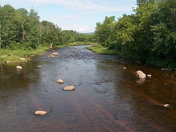
The Israel River in Lancaster, New Hampshire
|
|
| Country | United States |
| State | New Hampshire |
| County | Coos |
| Towns | Randolph, Jefferson, Lancaster |
| Physical characteristics | |
| Main source | Juncture of Cascade and Castle Brooks White Mountain National Forest 2,274 ft (693 m) 44°20′5″N 71°19′54″W / 44.33472°N 71.33167°W |
| River mouth | Connecticut River Lancaster 837 ft (255 m) 44°29′25″N 71°35′43″W / 44.49028°N 71.59528°W |
| Length | 23.2 mi (37.3 km) |
| Basin features | |
| Tributaries |
|
The Israel River, sometimes called Israel's River, is a 23.2-mile (37.3 km) long river in the White Mountains of New Hampshire, in the United States. It starts in a place called Low and Burbank's Grant. The river then flows mostly northwest, following along U.S. Route 2. It goes through the towns of Jefferson and Lancaster before it joins the larger Connecticut River.
History of the Israel River
Long ago, the Abenaki people lived in this area. They called the river Siwooganock. This name meant "place of the burnt pine trees."
Later, in 1754, English explorers came to the region. They first named the river "Powers River." This was to honor Captain Peter Powers, who was the first to explore this area.
The river's current name, Israel River, comes from an early hunter and trapper. His name was Israel Glines. He had a camp set up near where the river flows out. Israel's brother, John, also has a river named after him. It's called the Johns River and is nearby in Whitefield.
Where the River Flows
The Israel River begins near the bottom of Mount Adams. It starts where two smaller streams, Castle Brook and Cascade Brook, meet.
Many smaller streams flow into the Israel River. These smaller streams are called tributaries. Together, they collect water from the northwestern parts of Mount Adams and Mount Jefferson. These mountains are part of the Presidential Range. The river also gets water from the northern slopes of the Dartmouth Range and the southern slopes of the Pliny Range.
Some of the bigger streams that join the Israel River include:
- The South Branch
- The Mystic
- Castle Brook
- Cascade Brook
- Stag Hollow Brook
- Priscilla Brook (also known as Alder Brook)
- Red Brook
- Mill Brook
- Garland Brook
- Otter Brook
Several important roads cross over the Israel River using bridges. These include New Hampshire Route 115, U.S. Route 2, and New Hampshire Route 115A in Jefferson. In Lancaster, U.S. Route 3 crosses the river on Main Street. There are also smaller bridges for snowmobile trails. An old covered bridge on Mechanic Street in Lancaster also crosses the river. It was closed for repairs in 2004 but has since reopened.
 | Jewel Prestage |
 | Ella Baker |
 | Fannie Lou Hamer |


