
Whitefield, New Hampshire facts for kids
Quick facts for kids
Whitefield, New Hampshire
|
|
|---|---|
|
Town
|
|

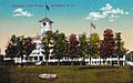
Town Hall and Library c. 1910
|
|

Location in Coos County, New Hampshire
|
|
| Country | United States |
| State | New Hampshire |
| County | Coös |
| Incorporated | 1804 |
| Villages | Whitefield Hazens |
| Area | |
| • Total | 34.74 sq mi (89.97 km2) |
| • Land | 34.26 sq mi (88.74 km2) |
| • Water | 0.47 sq mi (1.23 km2) 1.37% |
| Elevation | 948 ft (289 m) |
| Population
(2020)
|
|
| • Total | 2,490 |
| • Density | 73/sq mi (28.1/km2) |
| Time zone | UTC-5 (Eastern) |
| • Summer (DST) | UTC-4 (Eastern) |
| ZIP code |
03598
|
| Area code(s) | 603 |
| FIPS code | 33-84420 |
| GNIS feature ID | 0873754 |
Whitefield is a charming town located in Coös County, New Hampshire, in the beautiful White Mountains Region. As of the 2020 census, about 2,490 people call Whitefield home.
This town sits right at the northern edge of the famous White Mountains. It's where you'll find the Mount Washington Regional Airport and the White Mountains Regional High School. Whitefield is also part of the larger Berlin, NH-VT Micropolitan Statistical Area. The main part of town, called the Whitefield census-designated place (CDP), is where major roads like U.S. Route 3, New Hampshire Route 116, and NH Route 142 all meet.
Contents
Exploring Whitefield's Past
.jpg)
Whitefield has a cool history! It was the very last town to be officially given its charter by the English government. This happened on July 4, 1774. That's exactly two years before the Declaration of Independence was signed!
People aren't totally sure how Whitefield got its name. Some think it was named after George Whitefield, a famous English speaker who was friends with William Legge, the Earl of Dartmouth. Others believe the name came from the snowy white fields people would see when they entered the area from the mountains. The original name was "Whitefields," but the "s" was dropped in 1804 when the town officially became incorporated.
The Arrival of Railroads and Tourists
In the 1800s, something big happened: the railroad came to Whitefield! This made it much easier for people to visit. Tourists from cities like Boston, Hartford, New York, and Philadelphia discovered Whitefield. They loved the cool, clean mountain air, which was a nice break from the hot, smoky summers in their cities.
To welcome all these visitors, many inns and hotels were built. The most famous one is the Mountain View House, which opened in 1866. It sits on a hill with amazing views of the Presidential Range. Today, it's called the Mountain View Grand Resort & Spa and is one of New Hampshire's most luxurious hotels after a big renovation in the 2000s.
Railroad Lines and Architecture
Two important railroad lines used to cross right in the center of Whitefield. One was the Boston and Maine Railroad, and the other was the Maine Central Railroad. Even today, you can still see the special "diamond" track crossing where they met!
Whitefield also has many beautiful buildings in the Victorian architecture style. You can see a landmark bandstand built in 1875 on the town's common.
Whitefield's Geography
Whitefield covers about 90 square kilometers (34.7 square miles) of land. Most of this is land, with a small part being water. The Johns River flows right through the middle of town, and a smaller stream called Bog Brook also runs here.
The largest lake in Whitefield is Forest Lake, which is partly in the neighboring town of Dalton. Other lakes include Burns Lake and Mirror Lake. The two highest points in Whitefield are Howland Hill and Kimball Hill, both reaching about 522 meters (1,713 feet) above sea level.
-
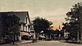
Main Street in 1907
-
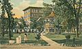
King's Square in 1905
-
Fiske House c. 1910
-
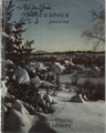
Village center c. 1948, cover of the January issue of the New Hampshire Troubadour
-
Mountain View House, Whitefield, NH
-
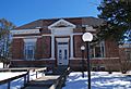
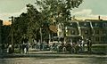
Whitefield Public Library


Neighboring Towns
Whitefield shares its borders with several other communities:
- Lancaster (to the north)
- Jefferson (to the east)
- Carroll (to the southeast)
- Bethlehem (to the southwest)
- Dalton (to the west)
Whitefield's Population
| Historical population | |||
|---|---|---|---|
| Census | Pop. | %± | |
| 1810 | 51 | — | |
| 1820 | 281 | 451.0% | |
| 1830 | 685 | 143.8% | |
| 1840 | 751 | 9.6% | |
| 1850 | 857 | 14.1% | |
| 1860 | 1,015 | 18.4% | |
| 1870 | 1,196 | 17.8% | |
| 1880 | 1,828 | 52.8% | |
| 1890 | 2,041 | 11.7% | |
| 1900 | 2,157 | 5.7% | |
| 1910 | 1,635 | −24.2% | |
| 1920 | 1,935 | 18.3% | |
| 1930 | 1,693 | −12.5% | |
| 1940 | 1,834 | 8.3% | |
| 1950 | 1,677 | −8.6% | |
| 1960 | 1,581 | −5.7% | |
| 1970 | 1,538 | −2.7% | |
| 1980 | 1,681 | 9.3% | |
| 1990 | 1,909 | 13.6% | |
| 2000 | 2,038 | 6.8% | |
| 2010 | 2,306 | 13.2% | |
| 2020 | 2,490 | 8.0% | |
| U.S. Decennial Census | |||
In 2010, there were 2,306 people living in Whitefield. These people lived in 976 households, and 613 of those were families. Most of the people in Whitefield are white (95.6%).
About 27.2% of households had children under 18 living there. Many households (48.3%) were married couples. The average household had 2.30 people, and the average family had 2.79 people.
The median age in Whitefield was about 44.7 years old. This means half the people were younger than 44.7, and half were older.
Getting Around Whitefield
Whitefield is easy to reach because several main roads cross here. These include New Hampshire Route 116, U.S. Route 3, and New Hampshire Route 142.
Even though they are not used much now, the old railroad lines of the Maine Central and Boston and Maine railroads still run through town. The Mount Washington Regional Airport is also located in Whitefield, making it easy to fly in and out. Since 2006, Whitefield has also had a public bus service called The Tri-Town Bus, which connects it to nearby towns like Lancaster and Littleton.
Places to Visit in Whitefield
If you're ever in Whitefield, here are a couple of interesting places you might want to check out:
- Weathervane Theatre: A great place to see live shows!
- Whitefield Historical Society Museum: Learn more about the town's past.
See also
 In Spanish: Whitefield (Nuevo Hampshire) para niños
