Dalton, New Hampshire facts for kids
Quick facts for kids
Dalton, New Hampshire
|
|
|---|---|
|
Town
|
|

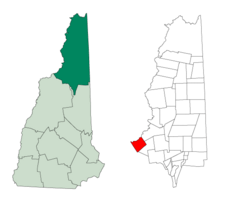
Location in Coös County, New Hampshire
|
|
| Country | United States |
| State | New Hampshire |
| County | Coös |
| Incorporated | 1764 |
| Villages |
|
| Area | |
| • Total | 28.1 sq mi (72.7 km2) |
| • Land | 27.5 sq mi (71.3 km2) |
| • Water | 0.5 sq mi (1.4 km2) 1.97% |
| Elevation | 915 ft (279 m) |
| Population | |
| • Total | 933 |
| • Density | 34/sq mi (13.1/km2) |
| Time zone | UTC-5 (Eastern) |
| • Summer (DST) | UTC-4 (Eastern) |
| ZIP code |
03598
|
| Area code(s) | 603 |
| FIPS code | 33-16820 |
| GNIS feature ID | 0873573 |
Dalton is a small town in Coös County, New Hampshire, in the United States. In 2020, about 933 people lived there. It is part of the larger Berlin, New Hampshire, area.
History of Dalton
Dalton became an official town in 1764. It was first called "Chiswick." This name came from a castle owned by the Duke of Devonshire.
In 1770, the town's name changed to "Apthorp." This was to honor the Apthorp family. Later, in 1784, Apthorp was split into two towns: Littleton and Dalton.
The name "Dalton" was chosen to remember Tristram Dalton. He was a merchant and a senator from Massachusetts.
Geography of Dalton
Dalton covers about 72.7 square kilometers (28.1 square miles). Most of this area, about 71.3 square kilometers (27.5 square miles), is land. The rest, about 1.4 square kilometers (0.5 square miles), is water. This means water makes up almost 2% of the town.
The highest point in Dalton is the top of Dalton Mountain. It is about 915 meters (2,150 feet) above sea level. Sea level is the average height of the ocean's surface.
The town also includes a small village called Cushman. Cushman is located right next to the Connecticut River. This river is very important because all the water in Dalton flows into its watershed. A watershed is an area of land where all the water drains into one main river or lake.
Much of Dalton's land is undeveloped. This means it is still farmland or forest. About 82% of the town's land is used this way.
Neighboring Towns
Dalton shares its borders with several other towns:
- Lancaster (to the northeast)
- Whitefield (to the east)
- Bethlehem (to the south)
- Littleton (to the southwest)
- Concord, Vermont (to the west)
- Lunenburg, Vermont (to the northwest)
People of Dalton
| Historical population | |||
|---|---|---|---|
| Census | Pop. | %± | |
| 1790 | 14 | — | |
| 1800 | 62 | 342.9% | |
| 1810 | 235 | 279.0% | |
| 1820 | 347 | 47.7% | |
| 1830 | 532 | 53.3% | |
| 1840 | 664 | 24.8% | |
| 1850 | 751 | 13.1% | |
| 1860 | 666 | −11.3% | |
| 1870 | 773 | 16.1% | |
| 1880 | 570 | −26.3% | |
| 1890 | 596 | 4.6% | |
| 1900 | 592 | −0.7% | |
| 1910 | 475 | −19.8% | |
| 1920 | 460 | −3.2% | |
| 1930 | 580 | 26.1% | |
| 1940 | 642 | 10.7% | |
| 1950 | 557 | −13.2% | |
| 1960 | 567 | 1.8% | |
| 1970 | 425 | −25.0% | |
| 1980 | 672 | 58.1% | |
| 1990 | 827 | 23.1% | |
| 2000 | 927 | 12.1% | |
| 2010 | 979 | 5.6% | |
| 2020 | 933 | −4.7% | |
| U.S. Decennial Census | |||
In 2000, there were 927 people living in Dalton. There were 374 households, which are groups of people living together. Most people in Dalton were White. A small number of people were African American, Native American, or Asian. Some people identified with two or more races.
About 28.9% of households had children under 18 living with them. Many households were married couples living together. The average household had about 2.48 people.
The population of Dalton includes people of all ages. In 2000, about 24.4% of the people were under 18 years old. About 14.6% were 65 years or older. The average age in Dalton was 41 years old.
See also
 In Spanish: Dalton (Nuevo Hampshire) para niños
 | Tommie Smith |
 | Simone Manuel |
 | Shani Davis |
 | Simone Biles |
 | Alice Coachman |

