
Lancaster, New Hampshire facts for kids
Quick facts for kids
Lancaster, New Hampshire
|
||
|---|---|---|
|
Town
|
||

Main Street
|
||
|
||
| Motto(s):
"The friendly town in the friendly state"
|
||

Location in Coös County, New Hampshire
|
||
| Country | United States | |
| State | New Hampshire | |
| County | Coös | |
| Incorporated | 1763 | |
| Villages |
|
|
| Area | ||
| • Total | 51.1 sq mi (132.3 km2) | |
| • Land | 50.0 sq mi (129.4 km2) | |
| • Water | 1.1 sq mi (2.9 km2) 2.19% | |
| Elevation | 863 ft (263 m) | |
| Population
(2020)
|
||
| • Total | 3,218 | |
| • Density | 64/sq mi (24.9/km2) | |
| Time zone | UTC-5 (Eastern) | |
| • Summer (DST) | UTC-4 (Eastern) | |
| ZIP code |
03584
|
|
| Area code(s) | 603 | |
| FIPS code | 33-40420 | |
| GNIS feature ID | 0873640 | |

Lancaster is a town in New Hampshire, United States. It is located along the Connecticut River in Coös County. The town gets its name from Lancaster, a city in England.
In 2020, about 3,218 people lived in Lancaster. This makes it the second-largest town in Coös County, after Berlin. Lancaster is the main town, or county seat, for Coös County. It is also seen as the entrance to the Great North Woods Region of the state.
The town includes smaller areas called Grange and South Lancaster. It is home to Weeks State Park and the famous Lancaster Fair. Part of the White Mountain National Forest is also located in the eastern part of the town.
The main village of Lancaster is a census-designated place (CDP). In 2020, about 1,941 people lived there. This village is found where U.S. Route 3 and U.S. Route 2 meet, along the Israel River.
Lancaster also hosts the Porcupine Freedom Festival. This is an annual event that celebrates ideas of freedom and personal choice. Thousands of visitors come to the festival each year.
Contents
History of Lancaster
The area now known as Lancaster was first called "Upper Coos." It was given this name in 1763 by Governor Benning Wentworth of colonial America. Captain David Page from Petersham, Massachusetts received the land.
The first settlers arrived in 1764. They were David Page, Jr. (Captain Page's son) and Emmons Stockwell. This was the first settlement north of Haverhill, New Hampshire, which was about 50 miles (80 km) away. At first, Lancaster even included land that is now part of Vermont.
The community was located on the northern Connecticut River. Early settlers faced challenges from some Native American groups. The town was later named after Lancaster, Massachusetts, which was the hometown of one of the first people to live there.
Reverend Joshua Weeks was one of the people who received land in the town. He was also part of a group that explored and named the mountains of the Presidential Range. Other important early explorers were Timothy Nash and Benjamin Sawyer. In 1771, they discovered Crawford Notch. This discovery made it possible to travel a shorter route to Portland, Maine.
Mills and Farming in Lancaster
Over time, many mills that used water power were built and then closed. These included sawmills for cutting wood and several mills that made potato starch. There was also one of the largest gristmills (for grinding grain) in New Hampshire. Factories that made carriages also operated here. A granite quarry, where stone was dug up, was active in the Kilkenny Range.
Because of its rich, fertile land next to the Connecticut River, Lancaster was a very productive farming town. In 1874, it was the twelfth most productive agricultural town in the state. A railway line, an extension of the Boston, Concord & Montreal Railroad, helped ship farm products to markets. It also brought tourists to the large hotels in the area.
Weeks State Park and Mount Prospect
Just south of the town center is Mount Prospect. This was the summer home of Senator John W. Weeks. He was important because he helped create the White Mountain National Forest through a law in Congress. In 1910, he bought several farms to create a large 420-acre (170 ha) estate.
Today, this estate is Weeks State Park. The park has a fire lookout tower and Senator Weeks' mansion. You can take tours of the mansion during the summer. In winter, if there's enough snow, the Mount Prospect Ski Tow operates on the mountain slope.
From the stone observation tower built in 1912 on top of the 2,059-foot (628 m) summit, you can see many mountains. These include the White Mountains and Green Mountains. The Presidential Range is to the southeast, and the Franconia Range is to the south. Mount Weeks, which is 3,900 feet (1,200 m) high, is in the Kilkenny Range to the northeast. This mountain is also named after Senator Weeks, as is the Weeks Medical Center.
The Weeks Memorial Library is a beautiful building in the Beaux Arts style. It was added to the National Register of Historic Places in 2000. John W. Weeks gave this library to the town to honor his father, William Dennis Weeks.
Geography of Lancaster
Lancaster covers a total area of about 51.1 square miles (132.3 km2). Of this, about 50.0 square miles (129.5 km2) is land, and 1.1 square miles (2.9 km2) is water. Water makes up about 2.19% of the town's total area.
The town is drained by the Israel River. All of Lancaster is part of the Connecticut River watershed. The Connecticut River forms the northwest border of the town. It also forms the border between New Hampshire and Vermont. The town also includes Martin Meadow Pond. The highest point in Lancaster is on a western part of Mount Cabot. It is 3,290 feet (1,000 m) above sea level.
Towns Near Lancaster
Lancaster shares its borders with several other towns:
- Northumberland (to the north)
- Stark (to the northeast)
- Kilkenny (to the east)
- Jefferson (to the southeast)
- Whitefield (to the south)
- Dalton (to the southwest)
- Lunenburg, Vermont (to the west)
- Guildhall, Vermont (to the northwest)
Climate in Lancaster
Lancaster has a humid continental climate (called Dfb in the Köppen system). This means it has warm summers with cool nights. Winters are cold and snowy, with an average of 70.3 inches (179 cm) of snow each year.
| Climate data for Lancaster, New Hampshire (1991–2020 normals, extremes 1892–present) | |||||||||||||
|---|---|---|---|---|---|---|---|---|---|---|---|---|---|
| Month | Jan | Feb | Mar | Apr | May | Jun | Jul | Aug | Sep | Oct | Nov | Dec | Year |
| Record high °F (°C) | 62 (17) |
64 (18) |
81 (27) |
90 (32) |
91 (33) |
95 (35) |
95 (35) |
94 (34) |
93 (34) |
82 (28) |
73 (23) |
62 (17) |
95 (35) |
| Mean daily maximum °F (°C) | 25.3 (−3.7) |
28.7 (−1.8) |
38.1 (3.4) |
52.2 (11.2) |
66.3 (19.1) |
75.0 (23.9) |
79.5 (26.4) |
77.9 (25.5) |
70.3 (21.3) |
56.5 (13.6) |
42.9 (6.1) |
31.1 (−0.5) |
53.6 (12.0) |
| Daily mean °F (°C) | 14.4 (−9.8) |
16.2 (−8.8) |
26.1 (−3.3) |
40.2 (4.6) |
52.8 (11.6) |
62.1 (16.7) |
67.0 (19.4) |
65.3 (18.5) |
57.7 (14.3) |
45.5 (7.5) |
33.9 (1.1) |
22.0 (−5.6) |
41.9 (5.5) |
| Mean daily minimum °F (°C) | 3.4 (−15.9) |
3.7 (−15.7) |
14.1 (−9.9) |
28.2 (−2.1) |
39.3 (4.1) |
49.3 (9.6) |
54.4 (12.4) |
52.6 (11.4) |
45.1 (7.3) |
34.5 (1.4) |
24.9 (−3.9) |
13.0 (−10.6) |
30.2 (−1.0) |
| Record low °F (°C) | −39 (−39) |
−40 (−40) |
−28 (−33) |
−1 (−18) |
18 (−8) |
28 (−2) |
32 (0) |
28 (−2) |
21 (−6) |
8 (−13) |
−9 (−23) |
−36 (−38) |
−40 (−40) |
| Average precipitation inches (mm) | 2.43 (62) |
2.03 (52) |
2.21 (56) |
3.15 (80) |
3.76 (96) |
4.37 (111) |
4.20 (107) |
4.13 (105) |
3.59 (91) |
4.18 (106) |
2.85 (72) |
2.90 (74) |
39.80 (1,011) |
| Average snowfall inches (cm) | 17.9 (45) |
17.8 (45) |
11.6 (29) |
4.0 (10) |
0.1 (0.25) |
0.0 (0.0) |
0.0 (0.0) |
0.0 (0.0) |
0.0 (0.0) |
0.6 (1.5) |
4.6 (12) |
19.5 (50) |
76.1 (193) |
| Average precipitation days (≥ 0.01 in) | 14.0 | 11.2 | 11.9 | 13.0 | 13.5 | 14.5 | 13.2 | 12.6 | 11.2 | 14.1 | 13.6 | 16.2 | 159.0 |
| Average snowy days (≥ 0.1 in) | 12.6 | 10.2 | 7.1 | 2.8 | 0.1 | 0.0 | 0.0 | 0.0 | 0.0 | 0.7 | 5.3 | 12.5 | 51.3 |
| Source: NOAA | |||||||||||||
Population of Lancaster
| Historical population | |||
|---|---|---|---|
| Census | Pop. | %± | |
| 1790 | 161 | — | |
| 1800 | 440 | 173.3% | |
| 1810 | 717 | 63.0% | |
| 1820 | 844 | 17.7% | |
| 1830 | 1,187 | 40.6% | |
| 1840 | 1,316 | 10.9% | |
| 1850 | 1,559 | 18.5% | |
| 1860 | 2,020 | 29.6% | |
| 1870 | 2,248 | 11.3% | |
| 1880 | 2,721 | 21.0% | |
| 1890 | 3,373 | 24.0% | |
| 1900 | 3,190 | −5.4% | |
| 1910 | 3,054 | −4.3% | |
| 1920 | 2,819 | −7.7% | |
| 1930 | 2,887 | 2.4% | |
| 1940 | 3,095 | 7.2% | |
| 1950 | 3,113 | 0.6% | |
| 1960 | 3,138 | 0.8% | |
| 1970 | 3,166 | 0.9% | |
| 1980 | 3,401 | 7.4% | |
| 1990 | 3,522 | 3.6% | |
| 2000 | 3,280 | −6.9% | |
| 2010 | 3,507 | 6.9% | |
| 2020 | 3,218 | −8.2% | |
| U.S. Decennial Census | |||

In 2010, the census showed that 3,507 people lived in Lancaster. There were 1,399 households and 880 families. The population density was about 70.4 people per square mile (27.2 people/km2).
Most of the people living in Lancaster were White (96.8%). A small number were African American (0.3%), Native American (0.7%), or Asian (0.6%). About 1.7% of the population identified as Hispanic or Latino.
The average household size was 2.35 people, and the average family size was 2.85 people.
Transportation in Lancaster
Lancaster is an important meeting point for roads. U.S. Route 2 and U.S. Route 3 both cross through the town. New Hampshire Route 135 also starts here and goes south to Dalton and beyond.
A railroad track, part of the Maine Central Railroad, runs along the Connecticut River. Another branch of the railroad goes from Coos Junction towards Jefferson.
The Mount Washington Regional Airport is located about 11 miles (18 km) away in the nearby town of Whitefield. Since 2006, Lancaster has also had a public transportation service called the Tri-Town Bus. This bus connects Lancaster with Whitefield and Littleton.
Notable People from Lancaster
Many interesting people have come from Lancaster:
- GG Allin (1956–1993), a punk singer.
- Merle Allin (born 1955), a punk bassist.
- Jacob Benton (1814–1892), who served as a congressman (a member of the U.S. House of Representatives).
- Louisa Dow Benton (1831–1895), a linguist (someone who studies languages).
- Edward E. Cross (1832–1863), a colonel during the Civil War.
- Irving W. Drew (1845–1922), who served as a U.S. senator.
- William W. Field (1824–1907), a legislator and farmer in Wisconsin.
- Benjamin F. Goss (1823–1893), a legislator in Wisconsin.
- Edward D. Holton (1815–1892), a legislator and businessman in Wisconsin.
- Margaret Hutchins (1884–1961), an American librarian and professor.
- Chester Bradley Jordan (1839–1914), the 48th governor of New Hampshire.
- Ossian Ray (1835–1892), who served as a congressman.
- William C. Stokoe (1919–2000), a linguist known for his research on ASL (American Sign Language).
- John W. Weeks (1860–1926), a U.S. senator and the 48th United States Secretary of War.
- Sinclair Weeks (1893–1972), who was the Secretary of Commerce during the Eisenhower Administration.
- Benjamin F. Whidden (1813–1896), the first U.S. ambassador to Haiti.
- Nathaniel White (1811–1880), a businessman, social reformer, and politician.
- Jared W. Williams (1796–1864), a U.S. senator, congressman, and the 21st governor of New Hampshire.
Sites of Interest
- John Wingate Weeks Historic Site & Lodge (built in 1913)
- Lancaster Historical Society Museum
- Wilder-Holton House (built in 1780)
- Garland Mill (built in 1856)
Images for kids
-
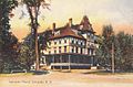
Lancaster House in 1908
-
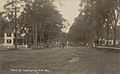
Main Street around 1910
-
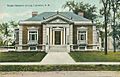
Weeks Library around 1912
-
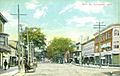
Main Street around 1910
-
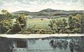
Mount Prospect around 1905
-
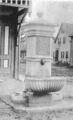
Benton Fountain in Lancaster, designed by Jacob Benton's wife, Louisa, in her husband's memory.


See also
 In Spanish: Lancaster (Nuevo Hampshire) para niños
