Kilkenny, New Hampshire facts for kids
Quick facts for kids
Kilkenny, New Hampshire
|
|
|---|---|

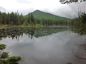
Unknown Pond with The Horn in the background, both of which are popular hiking destinations within the township.
|
|

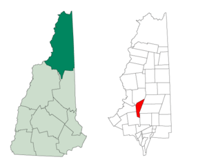
Location in Coös County, New Hampshire
|
|
| Country | United States |
| State | New Hampshire |
| County | Coös |
| Area | |
| • Total | 25.70 sq mi (66.56 km2) |
| • Land | 25.68 sq mi (66.51 km2) |
| • Water | 0.02 sq mi (0.05 km2) 0.08% |
| Elevation | 3,160 ft (960 m) |
| Population
(2020)
|
|
| • Total | 0 |
| Time zone | UTC-5 (Eastern) |
| • Summer (DST) | UTC-4 (Eastern) |
| Area code(s) | 603 |
| FIPS code | 33-007-39940 |
| GNIS feature ID | 873637 |
Kilkenny is a special kind of area called a township in Coös County, New Hampshire, United States. Unlike a regular town, a township in New Hampshire is an unincorporated area. This means it's not part of any town and has very little or no local government.
Kilkenny is located entirely within the beautiful White Mountain National Forest. It's a very quiet place, as the 2020 census showed that the township had a population of zero people.
Contents
History of Kilkenny
Kilkenny was first given to a group of people led by Jonathan Warner on June 4, 1774. It covered a large area of about 26,911 acres (108.9 km²). In the mid-1800s, it was home to only about 19 people. The township was named after the town and county of Kilkenny in Ireland.
Over time, the borders of Kilkenny changed. It once included a big part of what is now the eastern edge of Jefferson. This area was known as "Jefferson Highland." By the late 1800s, maps showed that Kilkenny's southern border had moved several miles south. This new border included Mount Waumbek and Pliny Mountain, which were uninhabited areas.
An old trail called the "Upper Ammonoosuc Trail" used to cross Kilkenny. It followed Priscilla Brook and went through a pass north of Pliny Mountain. This trail is no longer used today. In 1971, there was an idea to build a ski area in a place called the Willard Bowl. This area had an old railroad track that went up Garland Brook, used long ago for logging. By 1935, the tracks were gone.
Geography of Kilkenny
Kilkenny covers a total area of about 66.6 square kilometers (25.7 sq mi). Only a tiny part of this, about 0.05 square kilometers (0.02 sq mi), is water.
The township is home to some impressive mountains. These include Mount Waumbek of the Pliny Range and Mount Cabot of the Pilot Range. Both of these mountains are over 4,000 feet (1,219 m) high. Mount Cabot's summit is the highest point in Kilkenny, reaching 4,160 feet (1,268 m) above sea level.
All the water in Kilkenny eventually flows into the Connecticut River. Water from the southern part of the township and the west side of the Pilot Range flows into the Israel River. This river then joins the Connecticut River in Lancaster. Water from the northern part of Kilkenny flows into the Upper Ammonoosuc River. This river flows north and west to join the Connecticut River in Groveton.
Neighboring Areas
Kilkenny shares its borders with several other towns and townships:
- Stark (to the north)
- Milan (to the northeast)
- Berlin (to the east)
- Randolph (to the southeast)
- Jefferson (to the south)
- Lancaster (to the west)
Climate in Kilkenny
The climate in the Kilkenny area, based on data from nearby York Pond, New Hampshire, shows a wide range of temperatures throughout the year. Winters are cold with lots of snow, and summers are warm.
| Climate data for York Pond, New Hampshire, western part of Berlin close to Kilkenny Township (1991–2020 normals; extremes April 1989-present) | |||||||||||||
|---|---|---|---|---|---|---|---|---|---|---|---|---|---|
| Month | Jan | Feb | Mar | Apr | May | Jun | Jul | Aug | Sep | Oct | Nov | Dec | Year |
| Record high °F (°C) | 63 (17) |
68 (20) |
79 (26) |
86 (30) |
97 (36) |
93 (34) |
95 (35) |
94 (34) |
91 (33) |
82 (28) |
72 (22) |
65 (18) |
97 (36) |
| Mean maximum °F (°C) | 51 (11) |
51 (11) |
59 (15) |
74 (23) |
83 (28) |
87 (31) |
88 (31) |
86 (30) |
84 (29) |
75 (24) |
65 (18) |
52 (11) |
90 (32) |
| Mean daily maximum °F (°C) | 25.8 (−3.4) |
28.8 (−1.8) |
37.2 (2.9) |
50.1 (10.1) |
63.6 (17.6) |
72.3 (22.4) |
77.0 (25.0) |
75.6 (24.2) |
68.5 (20.3) |
54.9 (12.7) |
42.0 (5.6) |
31.1 (−0.5) |
51.8 (11.0) |
| Daily mean °F (°C) | 14.6 (−9.7) |
16.9 (−8.4) |
25.6 (−3.6) |
38.7 (3.7) |
51.3 (10.7) |
60.3 (15.7) |
65.0 (18.3) |
63.5 (17.5) |
56.0 (13.3) |
43.9 (6.6) |
32.7 (0.4) |
21.1 (−6.1) |
40.3 (4.6) |
| Mean daily minimum °F (°C) | 3.5 (−15.8) |
5.1 (−14.9) |
14.3 (−9.8) |
27.3 (−2.6) |
39.1 (3.9) |
48.3 (9.1) |
53.1 (11.7) |
51.3 (10.7) |
43.4 (6.3) |
33.1 (0.6) |
23.5 (−4.7) |
11.7 (−11.3) |
29.0 (−1.7) |
| Mean minimum °F (°C) | −19 (−28) |
−15 (−26) |
−9 (−23) |
14 (−10) |
26 (−3) |
35 (2) |
42 (6) |
39 (4) |
29 (−2) |
20 (−7) |
6 (−14) |
−10 (−23) |
−22 (−30) |
| Record low °F (°C) | −31 (−35) |
−35 (−37) |
−22 (−30) |
2 (−17) |
22 (−6) |
28 (−2) |
36 (2) |
31 (−1) |
21 (−6) |
12 (−11) |
−10 (−23) |
−27 (−33) |
−35 (−37) |
| Average precipitation inches (mm) | 3.22 (82) |
2.74 (70) |
3.23 (82) |
3.78 (96) |
4.48 (114) |
4.63 (118) |
4.74 (120) |
4.38 (111) |
3.62 (92) |
5.10 (130) |
3.67 (93) |
4.15 (105) |
46.25 (1,175) |
| Average snowfall inches (cm) | 20.3 (52) |
23.2 (59) |
15.9 (40) |
6.0 (15) |
0.4 (1.0) |
0.0 (0.0) |
0.0 (0.0) |
0.0 (0.0) |
0.0 (0.0) |
1.6 (4.1) |
7.5 (19) |
19.4 (49) |
105.0 (267) |
| Average extreme snow depth inches (cm) | 16 (41) |
23 (58) |
22 (56) |
9 (23) |
0 (0) |
0 (0) |
0 (0) |
0 (0) |
0 (0) |
1 (2.5) |
5 (13) |
13 (33) |
26 (66) |
| Average precipitation days (≥ 0.01 in) | 14 | 12 | 12 | 13 | 14 | 14 | 14 | 12 | 12 | 14 | 12 | 16 | 164 |
| Average snowy days (≥ 0.1 in) | 10 | 10 | 7 | 3 | 0 | 0.0 | 0.0 | 0.0 | 0.0 | 1 | 5 | 9 | 52 |
| Source: NOAA | |||||||||||||
Population of Kilkenny
| Historical population | |||
|---|---|---|---|
| Census | Pop. | %± | |
| 1800 | 18 | — | |
| 1810 | 28 | 55.6% | |
| 1820 | 24 | −14.3% | |
| 1830 | 27 | 12.5% | |
| 1900 | 47 | — | |
| 1920 | 2 | — | |
| 1960 | 0 | — | |
| 1970 | 0 | — | |
| 1980 | 0 | — | |
| 1990 | 0 | — | |
| 2000 | 0 | — | |
| 2010 | 0 | — | |
| 2020 | 0 | — | |
| U.S. Decennial Census | |||
As of the 2020 census, there were no people living in the township. This means Kilkenny is one of the few places in the United States with a population of zero!
See also
 In Spanish: Kilkenny (Nuevo Hampshire) para niños
 | Chris Smalls |
 | Fred Hampton |
 | Ralph Abernathy |

