Groveton, New Hampshire facts for kids
Quick facts for kids
Groveton, New Hampshire
|
|
|---|---|

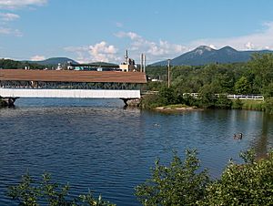
Covered bridge over the Upper Ammonoosuc River in front of former paper mill in Groveton. The Percy Peaks are in the distance.
|
|
| Country | United States |
| State | New Hampshire |
| County | Coos |
| Town | Northumberland |
| Area | |
| • Total | 2.15 sq mi (5.57 km2) |
| • Land | 2.06 sq mi (5.33 km2) |
| • Water | 0.09 sq mi (0.23 km2) |
| Elevation | 883 ft (269 m) |
| Population
(2020)
|
|
| • Total | 1,068 |
| • Density | 518.45/sq mi (200.19/km2) |
| Time zone | UTC-5 (Eastern (EST)) |
| • Summer (DST) | UTC-4 (EDT) |
| ZIP code |
03582
|
| Area code(s) | 603 |
| FIPS code | 33-32260 |
| GNIS feature ID | 0867268 |
Groveton is a small community in New Hampshire, United States. It's known as a census-designated place (CDP). This means it's a special area defined by the government for counting people. Groveton is the main village in the town of Northumberland. It is located in Coos County. In 2020, about 1,068 people lived there. You can find Groveton where U.S. Route 3 and New Hampshire Route 110 meet.
Contents
History of Groveton
Early Forts and Settlements
Fort Wentworth was an old fort built in 1755. It was a colonial fort, meaning it was built when America was still a group of colonies. The fort was located where the Upper Ammonoosuc River meets the Connecticut River. This spot is just a bit downstream from where Groveton is today.
The Paper Mill Era
For many years, a large paper mill was the most important business in Groveton. It started as Diamond International Papers. Over time, other companies like James River Paper Company and Wausau Paper took over the mill.
However, in 2008, Wausau Paper stopped making paper at the Groveton mill. This also meant that trains no longer stopped in Groveton. There were ideas to turn the mill into a biomass plant, which uses natural materials to make energy. But these plans didn't work out.
Later, the town decided to tear down the old mill. They did this to sell the scrap metal from the building. This helped the town make money. There were also plans for a new LNG (liquefied natural gas) plant, which would have created jobs. However, this project also did not happen.
New Energy: Hydrogen Power
Today, there are new plans for the old paper mill site. A company called Q Hydrogen is working to build a hydrogen production system. This system will use water to create hydrogen.
Electricity production has already started at the site. Most of the old mill buildings have been removed. This new project aims to bring modern energy production to Groveton.
The Old Steam Locomotive
Groveton has a cool piece of history on display: a coal-powered steam locomotive. This old train engine used to belong to the Odell Manufacturing Company paper mill. It was last used in the mid-1960s.
Now, it's a public display and a fun tourist attraction. Local groups help keep it in good shape. They even decorate it for Christmas!
Riverside Speedway and Adventure Park
If you like fast cars, Groveton has a place for you! Riverside Speedway opened in 1964. It's a 1/4-mile oval track where cars race.
The speedway has changed owners a few times. In 2019, it was renamed Riverside Speedway and Adventure Park. There are plans to make it a place for fun all year round. This could include ATV/UTV (all-terrain vehicle) events and snow machine racing. It's a popular spot for local auto racing.
Groveton on TV
Groveton was even featured on a national TV show! On January 5, 2012, the town was part of a story on The Early Show. The story talked about the paper mill and included interviews with people from Groveton.
Geography of Groveton
Groveton is located in the northern part of Northumberland town. It's in western Coos County. The community sits on the northwestern side of the Upper Ammonoosuc River. This river flows into the Connecticut River about one mile away. The Connecticut River forms the border between New Hampshire and Vermont.
U.S. Route 3 goes right through Groveton. If you go north on Route 3, it's about 26 miles to Colebrook. If you go south, it's about 10 miles to Lancaster, which is the main town in Coos County. New Hampshire Route 110 also starts in Groveton and goes east towards Berlin.
The Groveton area covers about 2.15 square miles (5.57 square kilometers). Most of this area is land, but a small part is water.
Population and People
Groveton is part of the Berlin, NH-VT Micropolitan Statistical Area. This means it's connected to the larger economic area around Berlin.
Here's how the population has changed over the years:
| Historical population | |||
|---|---|---|---|
| Census | Pop. | %± | |
| 1950 | 1,918 | — | |
| 1960 | 2,004 | 4.5% | |
| 1970 | 1,597 | −20.3% | |
| 1980 | 1,389 | −13.0% | |
| 1990 | 1,255 | −9.6% | |
| 2000 | 1,197 | −4.6% | |
| 2010 | 1,118 | −6.6% | |
| 2020 | 1,068 | −4.5% | |
| U.S. Decennial Census | |||
In 2010, there were 1,118 people living in Groveton. There were 491 households, which are groups of people living together. About 29% of these households had children under 18. The average household had about 2.28 people.
The median age in Groveton was about 41.9 years old. This means half the people were younger than 41.9, and half were older. About 22.9% of the residents were under 18 years old.
Education
Students in Groveton attend Groveton High School. This school is located on State Street (U.S. Route 3) at the north end of town. It serves students from Groveton and nearby towns. These towns include Northumberland, Stark, Guildhall, and Stratford.
Notable people
- GG Allin (1956–1993), a punk rock musician.
- Fred N. Cummings (1864-1952), a U.S. congressman from Colorado.
See also
 In Spanish: Groveton (Nuevo Hampshire) para niños
 | Kyle Baker |
 | Joseph Yoakum |
 | Laura Wheeler Waring |
 | Henry Ossawa Tanner |


