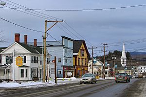
Colebrook (CDP), New Hampshire facts for kids
Quick facts for kids
Colebrook, New Hampshire
|
|
|---|---|

Colebrook, New Hampshire
|
|
| Country | United States |
| State | New Hampshire |
| County | Coös |
| Town | Colebrook |
| Area | |
| • Total | 2.69 sq mi (6.97 km2) |
| • Land | 2.62 sq mi (6.78 km2) |
| • Water | 0.07 sq mi (0.19 km2) |
| Elevation | 1,030 ft (310 m) |
| Population
(2020)
|
|
| • Total | 1,201 |
| • Density | 458.75/sq mi (177.15/km2) |
| Time zone | UTC-5 (Eastern (EST)) |
| • Summer (DST) | UTC-4 (EDT) |
| ZIP code |
03576
|
| Area code(s) | 603 |
| FIPS code | 33-13700 |
| GNIS feature ID | 2629721 |
Colebrook is a small village in New Hampshire, United States. It is also known as a census-designated place (CDP). This means it is a specific area that the government counts for population. Colebrook village is the main part of the larger town of Colebrook.
In 2020, about 1,200 people lived in the village part of Colebrook. The whole town had about 2,000 people. The population in the village has changed a bit over the years.
Contents
Exploring Colebrook's Location
Colebrook village is in the western part of the town of Colebrook. It is located next to the Connecticut River, which forms the border with Vermont. The Mohawk River also joins the Connecticut River here.
Important Roads in Colebrook
U.S. Route 3 is the main street in Colebrook. It goes north about 8 miles (13 km) to West Stewartstown. It also goes south about 26 miles (42 km) to Groveton.
New Hampshire Route 26 (Parsons Street) starts from Route 3. It goes east about 10 miles (16 km) to Dixville Notch. It also goes west across the Connecticut River into Vermont. New Hampshire Route 145 (Park Street) leaves US 3 just north of NH 26. It leads northeast about 13 miles (21 km) to Pittsburg.
How Big is Colebrook Village?
The Colebrook village area is bordered by the Connecticut River to the west. It includes Hughes Road to the north. To the east, it includes Corliss Lane and nearby homes. Farther south, the border follows Titus Hill Road and Skyline Drive. Then it turns west to Laflamme Drive and South Main Street.
The total area of Colebrook village is about 2.7 square miles (7.0 km2). Most of this area, about 2.6 square miles (6.8 km2), is land. A smaller part, about 0.1 square miles (0.2 km2), is water.
Who Lives in Colebrook?
| Historical population | |||
|---|---|---|---|
| Census | Pop. | %± | |
| 1950 | 1,265 | — | |
| 1960 | 1,550 | 22.5% | |
| 1970 | 1,070 | −31.0% | |
| 1980 | 1,131 | 5.7% | |
| 2010 | 1,394 | — | |
| 2020 | 1,201 | −13.8% | |
| U.S. Decennial Census | |||
In 2010, there were 1,394 people living in Colebrook village. There were 687 households, which means groups of people living together.
Most people in Colebrook village are white. A small number of people are from other backgrounds, including African American, Native American, and Asian. Some people are also Hispanic or Latino.
Families and Age Groups
About 25% of households in Colebrook village had children under 18 living with them. About 35% of households were married couples living together. Many households were made up of single individuals.
The average age of people in Colebrook village in 2010 was about 44.7 years old. About 20% of the people were under 18 years old. About 21% were 65 years old or older.
See also
 In Spanish: Colebrook (condado de Coös) para niños
 | Jackie Robinson |
 | Jack Johnson |
 | Althea Gibson |
 | Arthur Ashe |
 | Muhammad Ali |


