Pittsburg, New Hampshire facts for kids
Quick facts for kids
Pittsburg, New Hampshire
|
|
|---|---|

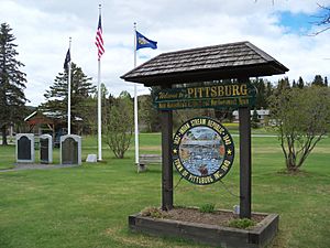
Park in Pittsburg
|
|

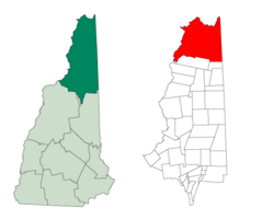
Location in Coös County, New Hampshire
|
|
| Country | United States |
| State | New Hampshire |
| County | Coös |
| Incorporated | 1840 |
| Named for | William Pitt, 1st Earl of Chatham |
| Villages | Pittsburg Happy Corner Idlewilde |
| Area | |
| • Total | 291.3 sq mi (754.5 km2) |
| • Land | 281.3 sq mi (728.6 km2) |
| • Water | 10.0 sq mi (25.8 km2) 3.43% |
| Elevation | 1,322 ft (403 m) |
| Population
(2020)
|
|
| • Total | 800 |
| • Density | 3/sq mi (1.1/km2) |
| Time zone | UTC−5 (Eastern) |
| • Summer (DST) | UTC−4 (Eastern) |
| ZIP code |
03592
|
| Area code(s) | 603 |
| FIPS code | 33-61780 |
| GNIS feature ID | 0871099 |
Pittsburg is a town located in Coös County, New Hampshire, United States. It is the northernmost town in New Hampshire. Pittsburg is also the largest town by land area in all of New England.
In 2020, about 800 people lived in Pittsburg. The main road through town is U.S. Route 3. Pittsburg is part of the larger Berlin, New Hampshire micropolitan area.
Contents
Pittsburg's Past: A Unique History
Pittsburg got its name from William Pitt, 1st Earl of Chatham. He was a very important leader in Great Britain long ago. Before Pittsburg officially became a town in 1840, it was known as the "Territory of Indian Stream." People started settling here around 1810.
The Republic of Indian Stream
For a short time in the 1830s, Pittsburg was its own tiny country! This happened because the border between the United States and Canada was not clear. This small, independent area was called the Republic of Indian Stream. It was a very unique part of history.
Historic Buildings in Pittsburg
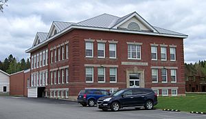
Pittsburg has some old and important buildings. The Indian Stream Schoolhouse was built in 1897. It is listed on both the national and state lists of historic places. The town hall, built in 1883, is also on the state's historic places list.
Pittsburg's Geography: Where New England Meets Canada
Pittsburg has a special location. It shares a border with Québec province in Canada to the west and north. It also borders the states of Maine to the east and a small part of Vermont to the southwest. The town of Clarksville is directly to the south.
Pittsburg is the only town in New Hampshire that borders Canada. It's also the only one that touches both Maine and Vermont. Plus, it's the only town completely north of the 45th parallel. This imaginary line is halfway between the Equator and the North Pole.
Rivers and Lakes
The Connecticut River forms part of New Hampshire's border with Vermont. Pittsburg is the only part of New Hampshire that is west of this river. The town is also home to the Pittsburg–Chartierville Border Crossing, which is New Hampshire's only border crossing into Canada.
The western edge of Pittsburg is marked by Halls Stream. This stream is one of the starting points of the Connecticut River. The exact border here was a bit confusing in the Treaty of Paris of 1783, which ended the American Revolutionary War.
Inside Pittsburg, you'll find the Connecticut Lakes. These lakes are where the Connecticut River officially begins! Pittsburg is the largest town in New Hampshire and New England by total area. It covers about 291 square miles (754.5 square kilometers). Most of this area is land, but about 3.43% is water.
High Points in Pittsburg
The highest point in Pittsburg is Stub Hill, which is 3,627 feet (1,106 meters) tall. Another important mountain is Mount Magalloway, which is 3,383 feet (1,031 meters) high. You can reach Mount Magalloway by hiking trails.
Neighboring Towns and Provinces
Pittsburg shares its borders with many different places:
- Chartierville, Quebec, Canada (north)
- Notre-Dame-des-Bois, Quebec, Canada (northeast)
- North Oxford, Maine (east)
- Atkinson and Gilmanton Academy Grant (southeast)
- Clarksville (south)
- Canaan, Vermont (southwest)
- East Hereford, Quebec, Canada (west)
- Saint-Venant-de-Paquette, Quebec, Canada (west)
- Saint-Malo, Quebec, Canada (west)
- Saint-Isidore-de-Clifton, Quebec, Canada (northwest)
Pittsburg's Climate: Weather in the North Country
Pittsburg has a type of weather called a "warm-summer humid continental climate." This means it has warm summers and cold, snowy winters.
The hottest temperature ever recorded at First Connecticut Lake in Pittsburg was 93°F (34°C). This happened on July 8, 1921, and again on July 19, 1953. The coldest temperature ever recorded was a very chilly -45°F (-43°C) on February 1, 1920.
| Climate data for First Connecticut Lake, New Hampshire, 1991–2020 normals, extremes 1918–present | |||||||||||||
|---|---|---|---|---|---|---|---|---|---|---|---|---|---|
| Month | Jan | Feb | Mar | Apr | May | Jun | Jul | Aug | Sep | Oct | Nov | Dec | Year |
| Record high °F (°C) | 60 (16) |
64 (18) |
77 (25) |
83 (28) |
91 (33) |
91 (33) |
93 (34) |
92 (33) |
89 (32) |
83 (28) |
72 (22) |
63 (17) |
93 (34) |
| Mean maximum °F (°C) | 45.3 (7.4) |
47.5 (8.6) |
55.0 (12.8) |
70.5 (21.4) |
79.9 (26.6) |
84.5 (29.2) |
85.1 (29.5) |
83.6 (28.7) |
80.6 (27.0) |
71.6 (22.0) |
61.1 (16.2) |
49.4 (9.7) |
87.0 (30.6) |
| Mean daily maximum °F (°C) | 22.4 (−5.3) |
25.2 (−3.8) |
34.2 (1.2) |
47.1 (8.4) |
61.5 (16.4) |
70.4 (21.3) |
75.0 (23.9) |
73.6 (23.1) |
66.4 (19.1) |
52.8 (11.6) |
39.9 (4.4) |
28.7 (−1.8) |
49.8 (9.9) |
| Daily mean °F (°C) | 11.1 (−11.6) |
12.8 (−10.7) |
21.9 (−5.6) |
36.3 (2.4) |
49.9 (9.9) |
59.3 (15.2) |
64.2 (17.9) |
62.7 (17.1) |
55.1 (12.8) |
43.5 (6.4) |
31.8 (−0.1) |
19.9 (−6.7) |
39.0 (3.9) |
| Mean daily minimum °F (°C) | −0.3 (−17.9) |
0.4 (−17.6) |
9.6 (−12.4) |
25.5 (−3.6) |
38.3 (3.5) |
48.3 (9.1) |
53.4 (11.9) |
51.7 (10.9) |
43.9 (6.6) |
34.1 (1.2) |
23.7 (−4.6) |
11.1 (−11.6) |
28.3 (−2.0) |
| Mean minimum °F (°C) | −27.0 (−32.8) |
−24.6 (−31.4) |
−18.5 (−28.1) |
6.6 (−14.1) |
25.1 (−3.8) |
32.6 (0.3) |
40.7 (4.8) |
38.4 (3.6) |
28.7 (−1.8) |
19.6 (−6.9) |
4.6 (−15.2) |
−14.0 (−25.6) |
−30.0 (−34.4) |
| Record low °F (°C) | −44 (−42) |
−45 (−43) |
−36 (−38) |
−17 (−27) |
14 (−10) |
25 (−4) |
29 (−2) |
28 (−2) |
18 (−8) |
8 (−13) |
−13 (−25) |
−44 (−42) |
−45 (−43) |
| Average precipitation inches (mm) | 3.02 (77) |
2.37 (60) |
3.04 (77) |
3.60 (91) |
4.47 (114) |
5.14 (131) |
4.91 (125) |
4.76 (121) |
4.00 (102) |
4.63 (118) |
3.62 (92) |
3.57 (91) |
47.13 (1,199) |
| Average snowfall inches (cm) | 30.3 (77) |
28.4 (72) |
24.6 (62) |
9.7 (25) |
1.0 (2.5) |
0.0 (0.0) |
0.0 (0.0) |
0.0 (0.0) |
0.0 (0.0) |
2.5 (6.4) |
14.6 (37) |
31.9 (81) |
143.0 (363) |
| Average extreme snow depth inches (cm) | 22.3 (57) |
27.9 (71) |
29.4 (75) |
16.9 (43) |
0.9 (2.3) |
0.0 (0.0) |
0.0 (0.0) |
0.0 (0.0) |
0.0 (0.0) |
1.2 (3.0) |
6.9 (18) |
14.9 (38) |
30.6 (78) |
| Average precipitation days (≥ 0.01 in) | 18.3 | 14.6 | 15.2 | 15.0 | 14.6 | 15.2 | 14.8 | 14.1 | 12.1 | 15.5 | 16.7 | 19.3 | 185.4 |
| Average snowy days (≥ 0.1 in) | 16.8 | 13.5 | 11.5 | 5.3 | 0.7 | 0.0 | 0.0 | 0.0 | 0.0 | 1.7 | 8.6 | 15.5 | 73.6 |
| Source 1: NOAA | |||||||||||||
| Source 2: National Weather Service | |||||||||||||
Pittsburg's People: Demographics and Community
| Historical population | |||
|---|---|---|---|
| Census | Pop. | %± | |
| 1840 | 315 | — | |
| 1850 | 425 | 34.9% | |
| 1860 | 413 | −2.8% | |
| 1870 | 400 | −3.1% | |
| 1880 | 581 | 45.3% | |
| 1890 | 609 | 4.8% | |
| 1900 | 687 | 12.8% | |
| 1910 | 624 | −9.2% | |
| 1920 | 1,311 | 110.1% | |
| 1930 | 671 | −48.8% | |
| 1940 | 820 | 22.2% | |
| 1950 | 697 | −15.0% | |
| 1960 | 639 | −8.3% | |
| 1970 | 726 | 13.6% | |
| 1980 | 780 | 7.4% | |
| 1990 | 901 | 15.5% | |
| 2000 | 867 | −3.8% | |
| 2010 | 869 | 0.2% | |
| 2020 | 800 | −7.9% | |
| U.S. Decennial Census | |||
In 2000, there were 867 people living in Pittsburg. The town had 386 households and 264 families. The population density was about 3.1 people per square mile.
About 22.3% of households had children under 18 living with them. Most households (59.1%) were married couples. The average household had 2.24 people, and the average family had 2.67 people.
The median age in Pittsburg was 46 years old. This means half the people were younger than 46 and half were older. About 18.9% of the population was under 18.
The median income for a household in Pittsburg was $38,516. For families, it was $42,500. The average income per person was $17,703. About 7.4% of all people in Pittsburg lived below the poverty line.
In 2014, the largest groups of people by ancestry in Pittsburg were English (30.9%), French or French Canadian (21.0%), and Irish (9.8%).
Tourism and Fun in Pittsburg
Pittsburg is a popular place for outdoor activities all year round. Many people visit for snowmobile and ATV riding.
Winter Adventures
In winter, thousands of people come to Pittsburg for snowmobiling. There are many trails that are maintained by the state and local clubs. These trails connect Pittsburg to other parts of New Hampshire. You can even ride into Maine, Vermont, and across the border into Canada!
Summer Fun
In summer, some of the same trails are used for ATVs. Pittsburg is also a great spot for fishing and hunting.
Lakes and Fishing
Pittsburg is home to the four Connecticut Lakes, Back Lake, and part of Lake Francis. There are also many smaller lakes and ponds. The lakes are stocked with fish every year, making them great for fishing weekends. The area is especially known for fly fishing. Two parts of the Connecticut River are set aside just for fly fishing, including a special "Trophy Stretch." People have been coming to the Connecticut Lakes Region to fish and hunt since the early 1900s.
Camping and Nature
Lake Francis State Park offers camping right by the lake. You can also fish and go canoeing on the lake or the Connecticut River. Deer Mountain Campground is another place to camp and have picnics along the Connecticut River.
Pittsburg was also a great place to see the total solar eclipse of April 8, 2024.
Notable People from Pittsburg
- Edgar Aldrich (1848–1921), a judge for the United States District Court in New Hampshire.
- Harry B. Amey (1868–1949), a lawyer who worked for the United States in Vermont.
- Luther Parker (1800–1853), an important political leader in the Republic of Indian Stream in the 1830s.
See also
 In Spanish: Pittsburg (Nuevo Hampshire) para niños
 | John T. Biggers |
 | Thomas Blackshear |
 | Mark Bradford |
 | Beverly Buchanan |


