Clarksville, New Hampshire facts for kids
Quick facts for kids
Clarksville, New Hampshire
|
|
|---|---|
|
Town
|
|

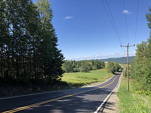
NH 145, looking north in Clarksville
|
|

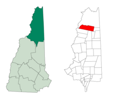
Location in Coös County, New Hampshire
|
|
| Country | United States |
| State | New Hampshire |
| County | Coös |
| Incorporated | 1853 |
| Area | |
| • Total | 62.4 sq mi (161.5 km2) |
| • Land | 60.3 sq mi (156.3 km2) |
| • Water | 2.0 sq mi (5.2 km2) 3.24% |
| Elevation | 1,980 ft (600 m) |
| Population
(2020)
|
|
| • Total | 294 |
| • Density | 5/sq mi (1.9/km2) |
| Time zone | UTC-5 (Eastern) |
| • Summer (DST) | UTC-4 (Eastern) |
| ZIP code |
03592
|
| Area code(s) | 603 |
| FIPS code | 33-13220 |
| GNIS feature ID | 0871098 |
Clarksville is a small town in northern Coös County, New Hampshire, United States. In 2020, about 294 people lived there. It is part of the Berlin, NH-VT Micropolitan Statistical Area.
Contents
Clarksville's History
The area where Clarksville is now was first known as "Dartmouth College Grant." This land was given to Dartmouth College. The college later sold parts of it to raise money.
Benjamin Clark and Joseph Murdock bought some of this land. The first time people counted how many residents lived here was in 1830. At that time, 88 people called this place home.
The town was officially formed, or incorporated, in 1853. This means it became an official town with its own local government. In 1872, it was renamed Clarksville. The name honors the Clark family, who were important early landowners.
In the late 1800s, the main businesses in Clarksville were making starch and maple sugar. For many years, companies that cut down trees (logging companies) have been the biggest employers in the town.
Geography of Clarksville
Clarksville is located in a beautiful natural area. To the north and west, it shares a border with Pittsburg. On its western side, there's a mile of waterfront along the Connecticut River. Across the river is the village of Beecher Falls in Vermont.
An important imaginary line called the 45th parallel north passes through Clarksville. This line is halfway between the Equator and the North Pole.
New Hampshire Route 145 is a main road that goes through the western part of town. It runs south from Pittsburg village. Before another major road, U.S. Route 3, was built, Route 145 was the only way to go north to Pittsburg.
Clarksville covers about 161.5 square kilometers (about 62.3 square miles). Most of this area is land, but about 5.2 square kilometers (2.0 square miles) is water. This means about 3.24% of the town is water.
The highest point in Clarksville is Crystal Mountain. It stands about 3,230 feet (985 meters) above sea level. This mountain is near the town's southern border.
Important water areas in Clarksville include parts of Lake Francis, Clarksville Pond, Carr Pond, and Dead Water Stream. Most of Clarksville's water flows into the Connecticut River watershed. A smaller part flows into the Androscoggin River watershed.
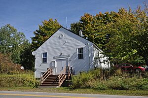
Clarksville's town hall is special because it's the highest town hall in New Hampshire. It sits at an elevation of 1,980 feet (604 meters).
Neighboring Towns
Clarksville is surrounded by several other towns and grants:
- Pittsburg (to the north)
- Atkinson and Gilmanton Academy Grant (to the east)
- Dix's Grant (to the southeast)
- Dixville (to the south)
- Stewartstown (to the southwest)
- Canaan, Vermont (to the west)
Clarksville's Population
The number of people living in Clarksville has changed over the years. Here's how the population has grown and shrunk:
| Historical population | |||
|---|---|---|---|
| Census | Pop. | %± | |
| 1840 | 88 | — | |
| 1850 | 187 | 112.5% | |
| 1860 | 249 | 33.2% | |
| 1870 | 269 | 8.0% | |
| 1880 | 328 | 21.9% | |
| 1890 | 325 | −0.9% | |
| 1900 | 307 | −5.5% | |
| 1910 | 271 | −11.7% | |
| 1920 | 410 | 51.3% | |
| 1930 | 215 | −47.6% | |
| 1940 | 225 | 4.7% | |
| 1950 | 171 | −24.0% | |
| 1960 | 179 | 4.7% | |
| 1970 | 166 | −7.3% | |
| 1980 | 262 | 57.8% | |
| 1990 | 232 | −11.5% | |
| 2000 | 294 | 26.7% | |
| 2010 | 265 | −9.9% | |
| 2020 | 294 | 10.9% | |
| U.S. Decennial Census | |||
In 2000, there were 294 people living in Clarksville. These people lived in 118 households, and 88 of these were families. The town had about 4.9 people per square mile.
Most of the people in Clarksville were White (about 95.92%). A small number were Native American (1.02%), and some people identified as being from two or more races (3.06%). About 1.70% of the population were Hispanic or Latino.
About 30.5% of the households had children under 18 living with them. Most households (66.9%) were married couples living together. About 19.5% of all households were single people living alone.
The average age of people in Clarksville was 44 years old. About 22.8% of the population was under 18 years old. About 11.6% were 65 years or older.
The average income for a household in Clarksville was around $40,179 per year. For families, the average income was about $44,688 per year.
See also
 In Spanish: Clarksville (Nuevo Hampshire) para niños
 | William Lucy |
 | Charles Hayes |
 | Cleveland Robinson |


